EMPLOYMENT
1. Mission. The primary mission of UAV units is to support their
respective Service component commands as a tactical RSTA system
providing the commander a capability to gather near-real-time data on
opposing force position, composition, and state of readiness. However,
as is the case with all assets and groupings within the joint force, the
joint force commander (JFC) has full authority to assign missions to and
task component UAVs to conduct operations in support of the overall
joint force. When appropriately tasked, UAV units are capable of
providing support to the JFC or other components of the joint force,
during day and night operations on land, air, or sea. The UAVs
discussed in this publication are nonlethal. Missions may include, but
are not limited to:
Surveillance for search and rescue (peacetime (SAR) and combat
(CSAR)).
Deception operations.
Maritime operations:
Nuclear, biological, and chemical (NBC) reconnaissance.
Special and psychological operations:
Route and landing zone reconnaissance support.
Adjustment of indirect fires and close air support (CAS).
Rear area security support.
BDA.
Radio and data relay.
(2) The UAV is a platform that can have single or multiple
sensors on board. A UAV can be described as a directed
collection sensor system gathering data as programmed by the
ground or as a result of shared (cued) sensor data available to
ground control or dictated by on-board sensor data. A successful
mission is dependent on detailed geographic guidance (i.e., exact
area to be surveyed) and collection requirements (i.e., mission
statement to help determine the optimum UAV payload) from the
higher headquarters' intelligence staff.
(2) Type and sophistication of payload used.
(3) Security levels required to exploit the product.
(4) Mission (BDA, etc.).
(5) Dissemination channels (i.e., desired communications flow
from the UAV payload to end user, to include any intermediate
processing facilities).
(6) Data format, method and rate of transmission, and type of
exploitation equipment.
(2) Effective dissemination of UAV intelligence products occurs
through a coordinated effort by producers, consumers, and
dissemination managers.
(2) The JFC has the authority to direct UAV assets for the
overall support of the joint force. The JFC may direct one
Service component to conduct UAV operations in support of another
component or task a Service component to provide UAV support to
the joint force or to another component on a mission-by-mission
basis. In any case, the supported commander's relationship with
the supporting UAV units should be clear. All Service component
UAV assets remain under the operational control of the Service
component. When a UAV capable commander is directed to support
another component or unit commander, the establishing authority's
directive should include the supporting mission priority relative
to other missions. Flight control of individual UAVs is always
retained by the UAV unit commander.
(3) UAV missions require coordinated flight planning. JFCs can
establish specific UAV flight routes and altitudes within their
respective areas of responsibility (AORs) through their airspace
control authority (ACA). Prior coordination with subordinate
component commanders should be accomplished prior to the
establishment of joint force UAV flight routes and altitudes.
Multiple different UAV flight routes and altitudes may be
established for such purposes as outbound and return UAV flights.
Specific UAV flight routes, established by connecting appropriate
air control points, can be designated in the airspace control
plan (ACP). Specific UAV operating altitudes can also be
established and published in the ACP. UAV flights, like manned
aircraft flights, must be coordinated to ensure deconfliction
with other airspace users, to include flights that cross
component boundaries. UAV missions should be coordinated with
the ACA, area air defense commander (AADC), and the JFACC. The
detailed procedures used to deconflict UAVs and other airspace
users are described on pages II-6 to II-13.
(2) The UAV has both an intelligence and operational
application. Joint force procedures for resolving conflicting
joint UAV support requests should be established. Conflicting
UAV missions being planned or conducted within the operational
boundaries of a particular commander should be resolved by that
commander. Joint force procedures must provide for resolution of
conflicts between Service component and joint force requirements.
Normally, the J-3 should prioritize requests and resolve any
conflicts in tasking joint force UAV assets.
(3) These requests will be forwarded to the appropriate
component commander with supporting UAV assets. The categories
of missions are the same as those for normal air support--
preplanned or immediate.
(4) Planning for UAV missions begins when the UAV unit receives
the tasking for UAV support. Preplanned missions may be
scheduled or on call. Scheduled missions occur at a definite
time; on-call missions place the UAV on standby, awaiting launch
instructions. In either case, UAVs with predesignated payloads
are assigned for specified periods according to mission
requirements from a supported unit. UAV flights within a Service
component's boundaries may be conducted without appearing in
either the joint force air tasking order (ATO) or special
instructions (SPINS). However, safety of flight reference to
airspace boundaries, altitudes, and times should be included in
the air control order (ACO).
(5) The UAV is ideally suited for immediate missions that were
not previously anticipated because of rapidly changing tactical
situations. As with any immediate mission, however, the
supported unit will have to take a predesignated payload that may
not be the payload of choice. Requests for immediate UAV support
are submitted by the fastest means to the joint force airspace
control agency; i.e., JAOC.
Communications. To the greatest extent possible, existing
communications nets should be used between the UAV unit, supported
units, and fire support or airspace control agencies. When the
tactical situation permits, the UAV unit should maintain radio
communications with the supported command centers and airspace
coordination element throughout flight operations. However, covert or
semicovert operations in emission controlled (EMCON) conditions may
preclude use of voice communications for operations security (OPSEC)
reasons. Additional working nets can be maintained with supported
units as appropriate. Units requesting support should coordinate
frequency management of UAV uplinks and downlinks and UAV unit
frequencies if the UAV is operating in areas other than its normal
operating areas. If downlinking information via the remote video
terminal (RVT) to the supported unit, the UAV unit will provide the
RVT while the supported unit will normally provide the RVT operator.
Airport Traffic Areas (ATAs) and Terminal Control Areas (TCAs).
ATAs and TCAs can be used to facilitate launch and recovery of UAVs if
the LRS is located at an airfield.
UAV Flight Routes and Transit Altitudes. JFCs can establish
specific UAV flight routes and altitudes within their respective AORs
through their ACA. Coordination with subordinate component commanders
should be accomplished prior to the establishment of joint force UAV
flight routes and altitudes. Multiple UAV flight routes and altitudes
may be established for such purposes as outbound and return UAV
flights. Specific UAV flight routes, established by connecting
appropriate air control points, can be designated in the ACP.
Specific UAV operating altitudes can also be established and published
in the ACP. UAV flight routes can consist of a designated mean sea
level (MSL) altitude, the airspace 500 feet above and below that
altitude and approximately 1,000 feet wide. UAV flight routes are
similar to an air corridor; however, they are normally located above
the coordinating altitude. The LRS, air control points used, and
specific UAV mission area will normally determine the length and width
of the flight route. Although manned aircraft flight through or in
UAV flight routes and altitudes is not restricted, all precautions
associated
with visual flight rules (VFR) apply to manned aircraft operating
through or in them. UAV flight routes and transit altitudes are
established and approved based on the UAV's mission and in accordance
with the ACP. Any deviation from established or approved routes and
altitudes must be coordinated with the ACA with cognizance over that
particular airspace in question.
Airspace Coordination Area. An airspace coordination area, a
restrictive fire support coordination measure, may be used to
deconflict the UAV's mission area with other airspace users.
Route and Altitude Separation. Route and altitude separation can
be used to deconflict the UAV with other airspace users throughout the
entire UAV mission. UAV routing is normally accomplished through
existing air control points.
Deconfliction. Any combination of the above measures can be used,
as required. Deconfliction depends on the command and control (C2)
function and coordination between the joint force components. All
aircraft working within a unit's boundaries will check in with the
appropriate airspace control agency for that area upon entry and be
advised of UAV status (LRS, location of airborne UAVs, route,
altitude, mission area, activation of UAV ATAs, TCAs, ROZs, ACAs,
etc.) The UAV mission flight crew will change the flight route,
altitude, and location of the UAV, as necessary, to deconflict with
other airspace users when directed by the appropriate ACA. The flow
of UAV status information begins with the UAV unit responsible for
launch and recovery of the UAV. Position of the UAV is constantly
monitored and controlled by the UAV mission flight crew at the UAV
unit via the ground control station (GCS). UAV status is passed from
the UAV unit to the supported unit or operational commander (via A2C2,
FSCC, etc.) and appropriate airspace control agencies (ASOC, AOC,
DASC, JAOC, etc.). The ACAs are responsible for relaying this
information to airborne command, control, and coordination platforms
(e.g., TAC(A), FAC(A), DASC(A), E-2C, ABCCC, AWACS, etc.). Airspace
control agencies and airborne command, control, and coordination
agencies are
responsible for advising all affected aircraft of UAV status upon
check-in.
(2) Figure II-2 depicts UAV system setup with control stations
at supported unit.
(3) Figure II-3 depicts UAV airspace control measures (overhead
view).
(4) Figure II-4 depicts UAV airspace control measures
(horizontal view).
Authorities that may be involved in planning and execution include
the J-3, the JFACC, the joint targeting coordination board (JTCB), the
joint intelligence center (JIC), the ACA, the AADC, and the fire
support coordination center (FSCC). Joint force intelligence and
national intelligence sources can be used to cue UAV operations to
specific areas of interest throughout the operation.
Mission planners must consider airspace management conflicts.
Prior to mission planning, mission planners will send the flight route
and altitudes to the responsible airspace management or airspace C2
element for initial deconfliction. They will also provide this
information to the ACA and other fire support coordination and control
agencies in accordance with established joint force procedures.
Mission planners must also consider any civil or political
constraints that may be imposed on UAV operations. Civilian or
politically imposed restrictions may affect operations in and around
military and civilian aviation control areas and zones, in the
vicinity of friendly forces, or in the vicinity of foreign shipping.
Figure II-1 UAV System Setup with Control Stations Collocated
Figure II-2 UAV System Setup with Control Stations at Support Unit
Figure II-3 UAV Airspace Control Measures (Overhead View)
Figure II-4 UAV Airspace Control Measures (Horizontal View)
The following are planning considerations for UAV missions:
(2) EEI to develop missions.
(3) Joint suppression of enemy air defenses (JSEAD).
(4) EW.
(5) Threat in the target area.
(6) Route weather, especially in the target area.
(7) Coordination with other friendly operations in the target
area.
(8) Data links and frequencies required by supported unit to
receive UAV signals.
(9) Launch and recovery times and location.
(10) Coordination of the transit route and flight path to
minimize UAV vulnerability and maximize expected value of the
mission.
(11) Synchronization with other airspace users.
(12) Request for coordination or provision of assets to analyze
the information beyond UAV unit capability, as required.
(13) Requested system performance capabilities. Shorter range
systems may require the relocation of support personnel and
ground equipment. If the requesting unit does not know the exact
capabilities needed, it should provide the tasking agency with
the most complete list of mission requirements possible.
(14) Security for the UAV units if they are required to move
into the supported unit's boundary.
(15) Support of UAV unit. If the UAV unit is not
self-supporting, it must coordinate with the supported unit for
required logistic support, such as materials handling equipment
(MHE), fuel and packaged petroleum, oils, and lubricants (POL)
and surface and/or air transportation.
Preprogrammed or Autonomous Control. The preprogrammed mode
allows the UAV to proceed on a preselected course and perform
specified patterns during loiter such as an orbit in a selected area
where it could be placed under real-time control of an airborne or
shipborne control station or as a countermeasure to hostile EW. The
UAV will be monitored by the GCS to ensure it maintains the programmed
altitude and position. After mission completion, the UAV proceeds via
programmed points toward a location where there is manual control for
terminal approach and landing. One special feature of all UAV
missions is a preprogrammed emergency flight mode called "return
home." The sequence for return home is as follows: if data link is
lost, the UAV automatically flies to a selected altitude and location
and holds. When command is reestablished, the UAV continues the
mission as planned. If command signals are not reestablished, the UAV
will continue holding until running out of fuel. Each flight includes
planning for a remote recovery checkpoint located so that acquisition
of the UAV by a control station is enhanced if return home is
initiated.
Disadvantages. The two primary UAV disadvantages include
environmental restrictions to flight and the requirement for LOS
between the UAV and the controlling or relay stations (ground,
airborne, or shipborne) processing the aircraft or payload. Future
capabilities for off-tether operations may eventually redress this
latter disadvantage.
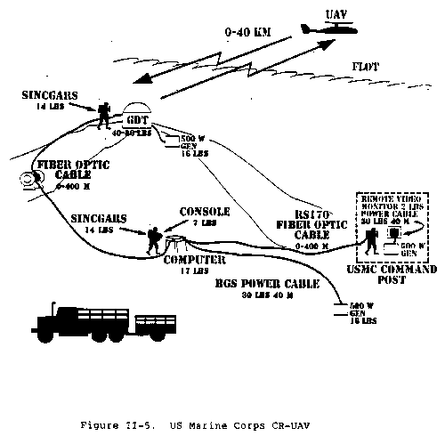
Disadvantages. The reduced size and limited endurance of the
CR-UAV requires repetitive launches to maintain surveillance for
extended periods. The operating range of the UAV is approximately 50
kilometers; therefore, operational site selection options may be
limited. The UAV's small size (200 pounds or less) means that
miniaturization is required before multiple payloads that perform
several missions can be carried on one flight. The small size of the
GCS necessitates support from other sources for complete analysis of
payload products.
Figure II-5 US Marine Corps CR-UAV
Figure II-6 US Army Augmented System (USMC system shaded)
Disadvantages. The SR-UAV unit requires significant
transportation, personnel, and logistic support. Depending on
configuration, three to eight C-141 load equivalents will be needed to
deploy the SR-UAV unit. This is not a consideration for the Navy SR
system which deploys with the host ship. The UAV size necessitates
ground and shipboard handling considerations which limits the
opportunity to operate from small clearings or unprepared areas and
can impact routine afloat flight operations without prior flight plan
integration. The present SR-UAV has engines that operate on gas fuel
that is not available through DOD logistic systems, but future block
upgrades may include engines that run on available fuel.
RSTA missions.
2. Intelligence Requirements, Exploitation, and Dissemination
(1) Naval surface fire support (NSFS).
Electronic warfare (EW) (including electronic attack (EA)),
signals intelligence (SIGINT), and directed energy sensor
reconnaissance.
(2) Over-the-horizon targeting (OTH-T).
(3) Ship classification.
(4) Antiship missile defense (ASMD).
(5) Antisubmarine warfare (ASW).
(6) Search and rescue (SAR).
(7) Mine defense support.
(1) Resupply for special operations and psychological operations
teams (scheduled and emergency).
Meteorology missions.
(2) Leaflet delivery and broadcast.
Requirements
3. Command and Control, Tasking, and Communications
(1) Through their RSTA collection capabilities, UAVs satisfy
many intelligence requirements. Operational objectives create
essential elements of information (EEI) which, in turn, orient
intelligence operations to support land, air, and maritime
operations. EEIs in turn determine the payload, flight paths,
and locations of RSTA activities conducted by UAVs. Intelligence
requirements, therefore, significantly influence UAV mission
tasking and planning.
Exploitation. UAV product exploitation can be accomplished at
various command levels, depending on the UAV system sophistication,
the payloads used, the
specific collection requirements to be satisfied, and the UAV unit
expertise. Considerations for determining who will do exploitation
are:
(1) Urgency between product receipt and exploitation.
Dissemination. Dissemination is the conveyance of intelligence
from the UAV payload to end-user, to include any intermediate
processing facilities, in a suitable form and timely manner.
(1) Dissemination formats include video, freeze-frame, voice
communications, recorded message traffic, and digital data.
Commonality and interoperability are the end user's primary
concerns. Prior planning should identify types and numbers of
communications paths to be used, the load requirements, and the
level of security.
Command and Control of UAVs Supporting the Joint Force. The UAV
provides the commander the ability to perform near-real-time RSTA to
develop and receive information. However, UAV units are only designed
to support a single command or component. When UAV units are tasked
to support more than one command or Service component simultaneously,
degradation of effectiveness can result.
(1) The Services have developed and integrated UAV employment
techniques to enhance their overall warfighting capabilities.
The UAVs, their support
personnel, and GCSs will normally remain under operational
control of their Service component commander.
Tasking
(1) The JFC does not need to establish a separate and distinct
requesting process for UAV support. Requesting procedures for
UAV support, from either intelligence agencies or operational
units, should be
included in the normal air request procedures of the joint force.
Component requests for UAV support from another Service component
should be made through the JFC. Joint Pub 3-56.24 contains
examples of air request support (AIRREQSUP) and air request
reconnaissance (AIRREQRECON) messages.
4. Airspace Control. Airspace control is provided to prevent mutual
interference from all users of the airspace, facilitate air defense
identification, and accommodate and expedite the flow of all air traffic
safely. The JFC, normally through his ACA, establishes joint force
airspace control procedures in the ACP in accordance with the guidance
contained in Joint Pub 3-52, "Doctrine for Joint Airspace Control in the
Combat Zone." UAV operations must be coordinated with the ACA to
provide safe separation of UAVs and manned aircraft and to prevent
engagement by friendly air defense systems. The established principles
of airspace management used in manned flight operations normally apply
to UAV operations but may be waived by the JFC. UAV airspace
requirements do not differ from other low performance aircraft. The UAV
is difficult to acquire visually and does not provide a clear radar
signature presenting a potential hazard to high performance aircraft.
To limit the hazard to fixed-winged aircraft, separation between manned
aircraft and UAVs is required. UAV missions are both preplanned and
immediate in nature. Preplanned UAV flights in support of the JFC or
another service component should be included in the joint force ATO,
SPINS, or ACO. Immediate UAV missions will be coordinated with
appropriate airspace control agencies (i.e. ASOC, DASC, AOC, TACC) to
provide safe separation between manned and unmanned aircraft and prevent
inadvertent engagement by friendly air defense artillery (ADA) or
fighters. UAVs are launched from UAV launch and recovery sites (LRSs),
which may be either airfields, unimproved field locations, or large
flight decks afloat depending on the type or size of UAV. After launch,
the UAV can climb to flight route or transit altitude (normally above
the coordination altitude) over the LRS, or climb enroute to the UAV's
mission area. Once at the mission area, the UAV climbs or descends, as
required to conduct its mission. During the UAV mission, route and
altitude changes may be required. Any changes must be coordinated with
the ACA. Upon mission completion, UAVs return to their LRS again using
a UAV flight or transit altitude. The following procedures should be
used to deconflict UAVs and other airspace users:
Restricted Operations Zones (ROZs). A ROZ should be established
for a LRS and for each UAV mission area. Launch and recovery of UAVs
from an LRS that is not located at an airfield can be facilitated by
establishing a ROZ around the LRS. The ROZ around the LRS is normally
circular, centered on the launch site, is 2 to 3 kilometers in
diameter, and allows the UAV to climb and/or descend from transit
altitude over the LRS. A ROZ established for shipboard UAV operations
will conform to the ship's normal airspace control zone. A ROZ may be
established around the UAV's mission area to facilitate mission
accomplishment. The size and altitudes for the UAV mission area ROZ
is dependent on UAV capabilities and mission requirements.
5. Planning
(1) Figure II-1 depicts UAV system setup with control stations
collocated.
Actual mission planning is conducted by the UAV unit, based on the
requirements of the supported unit. Planning requires the
consideration of many factors such as intelligence concerning known or
suspected enemy locations, the JFC's priorities, system performance
capabilities, and mission payload capabilities, to select a flight
path that maximizes mission success.
6. Conduct of the Mission. UAVs can be manually controlled or
preprogrammed to fly autonomous missions. Most UAV operations require
manual launch and recovery. For multi-UAV operations, one UAV may be
put in the preprogrammed mode to fly a specified course or to circle a
designated target area while an additional UAV is launched and manually
controlled.
(1) Purpose of the mission.
Manual Control. After launch, the UAV climbs to a predetermined
altitude under autopilot or manual control of the internal pilot at
the GCS. The mission commander ensures that the UAV adheres to the
planned mission. The supported unit will coordinate with the
appropriate agencies for any changes it directs. UAV positions will
be maintained and, when necessary, reported to appropriate airspace
control agencies. Upon conclusion of the mission, the UAV returns via
designated control points to the recovery area.
7. UAV System Advantages and Disadvantages
Advantages. UAV systems gather combat information in real or near
real time and transmit it to their ground stations by data link day or
night. This capability reduces the need for manned aircraft to
overfly enemy territory. Transportation and logistic requirements to
deploy the UAV systems are usually smaller than other airborne
intelligence collection resources. Current UAV
systems are fairly interoperable between the Services and extensive
special training is not required to use much of the information
provided by UAVs. Further, UAV systems are designed to interface with
other intelligence systems such as the all-source analysis system
(ASAS) and Joint Surveillance Target Attack Radar System (Joint
STARS).
8. Close-Range Unmanned Aerial Vehicle. The CR-UAV system is composed
of a baseline system (US Marine Corps) and an augmented system (US Army,
using the baseline system as a launch and recovery unit) as depicted in
Figures II-5 and II-6.
Advantages. CR-UAV has extremely small transportation
requirements when compared to other UAV systems or to reconnaissance
(RECCE) units that employ electronic equipment. It can be effectively
operated from small clearings, parking lots, or compounds. The UAV's
small visual and radar signatures enhance its survivability. CR-UAV
is relatively simple to operate, requires few dedicated personnel, and
allows resident military specialties, such as forward observer or
intelligence analyst, to be integrated easily. This feature increases
the operational flexibility of the CR-UAV system. The ground control
unit design allows for automatic or mechanical interface with other
DOD systems such as the all-source analysis system (ASAS) and the
ground station module (GSM).
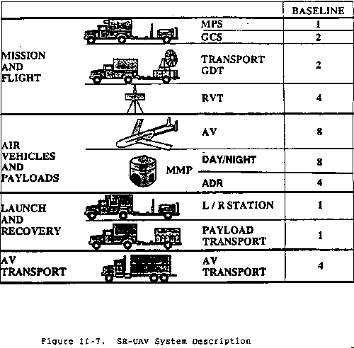
9. Short-Range Unmanned Aerial Vehicle. The SR-UAV is composed of a
baseline system (Figure II-7) that can be adjusted by the addition or
removal of personnel and equipment to meet operational needs. The
baseline system consists of an mission planning station (MPS), GCS, air
vehicles (AVs), payloads, an LRS, and RVTs. Present SR-UAV payload
provides a day or night imagery intelligence (IMINT) capability in
addition to radio relay. A variety of additional multiple mission
payloads are planned as system growth improvements.
Advantages. The SR-UAV's increased range and endurance allows for
the system to operate over a significant area. Payload capacity
allows for the UAV to carry multiple payloads, executing several
missions on a given flight. The ability to analyze the payload
product is resident within the system ground or ship component
equipment. During preprogrammed autonomous flight, several hours of
data can be recorded and stored on board the UAV and then retrieved
and interpreted after UAV recovery. The UAV may also maintain a
constant link with GCS to provide real-time coverage, albeit at
reduced ranges. RVTs can be supplied to provide downlink information
during mission execution to selected agencies such as the command
centers or joint intelligence centers.
Figure II-7 SR-UAV System Description
12-26-1996; 15:25:55