
AVDEP-HDBK-12

Mapping, Charting, & Geodesy
Handbook
For the digitally perplexed,
the cartographically disoriented,
and the geospatially doomed,
custom tailored for self-resuscitation
in the privacy of your own cubicle.
Version 2.0
1 June 1995
John H. Harden, Jr.
Zdenka S. Willis, LCDR, USN
Avionics Systems Engineering Department
Air-4.5
Introduction to Version 2.0
Your response to the TEAM MC&G Handbook greatly exceeded our modest expectations. Thank you for the encouraging feedback! Although written specifically for naval aviation system developers in their language, a strong, unexpected external demand for copies surprised us. It seems that much of the handbook has generic application to MC&G fans throughout DoD. Other commands and Services intend to imitate it!
You thought we hit the right issues. You particularly appreciated the plain, concise English. You also cited the timeliness of Section VII on product accuracy – but needed more – and the value of Appendix C, Useful Statistics About Selected DMA Products. We took your comments to mean that the handbook was worth further improvement.
Version 2.0 is our answer. Most of the first version survived your high expectations and remains intact. We corrected all obsolete information and known errors. We added an appendix with additional information on accuracy. We included additional guidance when dealing with contractors and some late breaking news on Military Specifications and Standards. After doing that, we decided to redo the text heavy format to make the handbook visually appealing and ultimately more accessible. We did this because too many folks in naval aviation still don’t know what they need to know about m, s, & j.
Originally, we planned this as our last hard copy version to reflect the 1 October 1994 TEAM reorganization, followed by soft copy changes after that. We have changed this revision strategy. We will publish future hard copy versions as significant changes warrant. We will uniquely identify them by a whole number with a suffix of "point zero," such as this one, Version 2.0, and distribute them, using our latest mailing list. A version suffix of one through nine, e. g., Version 2.1, means that we consider the changes minor. These versions will be available electronically through the NAVAIR Headquarters Network (NHN).
Introduction
This handbook is for all members of the Naval Aviation Systems Team (TEAM). It is your initial reference for information about Mapping, Charting, and Geodesy (MC&G) support from the Defense Mapping Agency (DMA).
This handbook will:
clarify MC&G relevance to TEAM systems development and your job,
guide you in acquiring a necessary basic competence in MC&G,
explain the process for you to get DMA MC&G data and services, and
point you to help on MC&G within the TEAM, DMA, and elsewhere.
You don’t have to read the whole thing front to back right away, if ever. We organized it for browsing. For more details on a particular topic see the
Where to find it:
box at the end of each section.
We recognize that you are busy and your work is important, so we included an Executive Gouge that distills the essence of the handbook on one page. If you read the Executive Gouge on the next page and intuitively grasp the fundamental implications of each nugget of truth…well, you need read no more! Furthermore, you become a Geospatial Information Prophet and can grant audiences with those of dimmer wattage than yourself. Then you can reveal to DMA the next crisis area that needs mapping which is, of course, where our next war will be. If anyone needs to know, they do.
One other thing. When we generally speak of warfighters, we are not talking just about the shooters. We mean all of you on the TEAM: developers, planners, everybody. We know your support is integral to their success.
If you now are beginning to wonder:
"Why is MC&G so important to the TEAM anyway?"
– please read on!
EXECUTIVE GOUGE
The least understood part of weapon systems development is MC&G! (p. 1)
Global geospatial information promises unprecedented interoperability. (p. 1)
A weapon system without MC&G is like a weapon system without funding. (p. 1)
DMA’s significance is not proportional to its DoD budget. (p. 2)
DMA is the sole DoD provider of MC&G. (p. 2)
Identifying MC&G requirements early ensures MC&G data in the Fleet. (p. 2)
The MC&G Team is in Air-4.5. (p. 3)
Developmental and operational MC&G requirements are different. (p. 5)
The warfighter’s NEEDS reign supreme! (p. 5)
Digital data structures constrain systems development. (p. 6)
Raster is faster but vector is smarter. (p. 7)
MIL-SPECs and MIL-STDs are endangered species. (p. 10)
Not using standard DMA data will cost BIG $$. (p. 14)
DMA can’t automatically provide MC&G data to contractors or foreign countries. (p. 10)
GGI&S is a vital part of the evolving national spatial data infrastructure. (p. 14)
GGI&S will be DoD’s worldwide spatial reference base for interoperability. (p. 14)
Standard DMA products and services are free to DoD, unique MC&G products COST! (p. 14)
DMA provides MC&G software for display and fusion, but little analytical software. (p. 19)
DMS is the TEAM’s source of MC&G training. (p. 21)
Arranging demonstrations of MC&G products and capabilities is easy. (p. 23)
It takes acquired skills to order DMA products. (p. 26)
Misusing DMA products can be fatal. (p. 31)
Gravity is not just a good idea. IT’S THE LAW! Ignore gravity and DIE! (p. 32)
DMA product accuracy defines the warrior’s envelope of reliable use. (p. 36)
A weapon system can be precise, but inaccurate. (p. 37)
Advanced PGMs have complicated the targeting problem. (p. 36)
WGS 84 is the standard DoD position reference system. (p. 39)
Speed is life, but the MISSION IS POSITION! (p. 40)
The keys to success: datums, reference systems, transformations, accuracies,
precise positioning, WGS, and GPS. (p. 40)
Targeting from maps is as effective as PQL (Partial Quality Leadership). (p. 41)
Practice safe positioning. JUST DO IT! (p. 42)
Where is the TARGET? The best coordinates win! BC = CMF. (p. 42)
GGI&S potential as a force multiplier is truly awesome. (p. 46)
Soon the TEAM can play with digital dirt in the "electronic sand table." (p. 47)
Digital FLIP will support mission planning and a paperless cockpit. (p. 50)
The TEAM directly influenced MUSE 2.0 software improvements. (p. 52)
The TEAM needs to give DMA feedback! (p. 53)
The datum and the spheroid are different. (p. 81)
Coordinate conversion in cockpits is tricky. (p. 84)
Contents
Page
Introduction to Version 2.0 i
Introduction iii
Executive Gouge v
Section I. Do You Need MC&G Support For Your TEAM Activity? 1
Geospatial Information 1
DMA 1
Interoperability 2
Memorandum Of Understanding 3
Where To Find It 3
Section II. MC&G Requirements In TEAM Systems Development 5
Two Kinds Of Requirements 5
Some Basic Considerations 5
The Role Of CNO (N096) 9
The Role Of CNMOC 9
The Role Of NRL 9
Evaluating DMA Prototypes 10
MIL-SPEC And MIL-STD Waivers 10
When Your Contractor Wants MC&G Data 10
MC&G And Foreign Military Sales 11
Where To Find It 11
Section III. Building Your MC&G Library 13
DoD Documents 13
Military Specifications And Standards 13
DMA Documents 13
Other Sources 17
DMA Catalogs 17
DMA Software 18
Where To Find It 19
Section IV. How To Get MC&G Training 21
Off Site 21
On Site 21
Where To Find It 21
Section V. Demonstrations Of DMA Products And Capabilities 23
At The DMA Hydrographic/Topographic Center 23
At The DMA Combat Support Center 23
At The DMA Warrior Support Center 23
On Site Deployment 23
In Air-4.5 23
On Your Desktop 23
Where To Find It 23
Section VI. How To Get DMA Products 25
Basic Information 25
Routine Ordering 26
Not So Routine Ordering 27
Voice Customer Assistance 28
Ordering For The TEAM 28
Where To Find It 29
Section VII. A Bit About DMA Product Accuracy And Such 31
Some History 31
The Shape Of Our Earth 31
Projections and Scales 33
Images And Maps 34
Color Accuracy 35
Coordinate Reference Systems 35
Measures Of Accuracy 36
Accuracy Versus Precision 37
Pseudo Accuracy 38
Datums 38
WGS 84 39
Datum Transformation and Coordinate Conversion 40
The Global Positioning System 40
Precise Target Coordinate Sources 41
Complete Position Reporting 43
Where To Find It 43
Section VIII. Keeping Up With MC&G Progress 45
Sources Of Information 45
Another Peek At The Future 45
New DMA Initiatives 46
Developmental Products And Services 48
Where To Find It 52
Section IX. Measuring DMA Combat Support Performance 53
The Need 53
Customer Service Measurement 53
Quality Feedback 53
Joint Teams 56
Where To Find It 56
Acknowledgments 57
Appendices
APPENDIX A. Key MC&G Players 59
APPENDIX B. Matrix Of TEAM Customers And DMA Products 63
APPENDIX C. Useful Statistics About Selected DMA Products 67
APPENDIX D. Accuracy And Positional Error 75
APPENDIX E. Datums, Grids, And Cockpits, Oh My 81
APPENDIX F. Those Inevitable Acronyms 85
Section I
Do You Need MC&G Support For Your TEAM Activity?
Everyone on the TEAM has questions, problems, and issues; this is the nature of systems development. The common backdrop supporting Department of Defense (DoD) weapon systems and their development is MC&G spatially referenced data. This being true, you might wonder: "Is my problem, issue, or question related to MC&G?" If your weapon system needs reference or positioning information, it uses geospatial information and you need to know about MC&G. Your system won’t work without it. The newest weapon systems require digital geospatial information in increasing amounts, quicker, and on varying media for successful mission operations. So what do you know about this thing called geospatial information?
1. Geospatial Information. Geospatial information is dimensional data referenced to the earth and its environment. Map makers give the information its meaning through formal representations that describe distances, direction, size, and relative position. Spatial objects, which vary in location or time, are either picture elements (pixels), points, lines, or areas (sometimes called polygons). Cartographers measure, encode with coordinates, and further define these objects with other attributes and values. Then they store them in raster or vector data models for the warfighter’s later use. This information will print or display as text, imagery, or accurate models of the real world. For maximum value to the warfighter, geospatial information should be worldwide, highly accurate, continuously updated, electronically delivered, and referenced in space in a universally usable way.
These ideas compose a new notional concept from DMA called Global Geospatial Information and Services (GGI&S). GGI&S is the future of MC&G. Warfighters will use and exchange GGI&S data anytime, anywhere. They will use it for measuring, mapping, monitoring, modeling and simulation, mission rehearsal, and visualizing and evaluating the battle space. Other new and exciting spatial reasoning applications await discovery. It will take many years, significant resources, and unprecedented cooperation throughout DoD to achieve the ultimate potential that an infrastructure of geospatial information promises. To be successful, GGI&S must meet the needs of informed customers like you, rather than MC&G data providers like DMA.
2. DMA. DMA, established in 1972 from existing Service MC&G assets, provides MC&G combat support to the warfighters. DMA is a joint DoD agency under the direction and control of the Assistant Secretary of Defense for Command, Control, Communications, and Intelligence (ASD C
3I). The DMA Director, a flag officer, reports to the Chairman, Joint Chiefs of Staff (JCS) for operational matters. DMA also speaks for DoD on international MC&G issues.DMA employs approximately 7,700 civilians and about 275 military personnel representing all Services. Professional specialties include cartography, geodesy, geology, astronomy, oceanography, remote sensing, photogrammetry, optics, computer science, and engineering. The DMA FY93 budget was $763 million, less than a day’s worth of the DoD budget.
DMA is the sole DoD provider of MC&G support to joint warfighter operations. Some examples are: combat, search and rescue, peacekeeping, evacuations, humanitarian efforts, counter drug operations, disaster relief, crisis, surveillance, deterrence, planning, training, special operations, and, of course, systems development.
Many DoD elements, including the development community, don't know the wide range of MC&G products and services free to them from DMA. DMA makes more than 230 MC&G product lines including 70 digital ones. More are on the way.
Advances in technology and warfighter expectations require DMA MC&G products and services of improved accuracy and currency, increased information content, covering more diverse areas of the world with faster delivery. These higher expectations are especially challenging in the present DoD budget reduction that has significantly affected DMA.
3. Interoperability. Joint Pub 1-02 says: "Interoperability is the ability of systems, units or forces to provide services to, and to accept services from, other systems, units or forces, and to use the exchanged services to operate effectively together." Talk about a classic understatement with leading implications!
DMA’s goal for systems development is straightforward – joint MC&G interoperability in the battle space!
The DoD Mapping, Charting, and Geodesy Joint Interoperability Board (MJIB) is a flag level body chaired by the DMA Director. It ensures proper consideration of DoD MC&G standards and interoperability in systems development. The Oceanographer of the Navy represents the TEAM at MJIB meetings. The Geospatial Standards Management Committee (GSMC) is the working level support group that identifies issues and makes recommendations to the MJIB. The DMA Liaison Officer (DMALO) and the TEAM Meteorological/Oceanographic (METOC) Officer bring TEAM system development concerns to the GSMC.
4. Memorandum Of Understanding. In June of 1993, the Director of DMA and the Commander of Naval Air Systems Command signed a Memorandum of Understanding that established a DMA Liaison Office at NAVAIR. NAVAIR has an urgent need to develop and identify MC&G requirements as early as possible in the system development cycle. The avoidable costs are significant. The DMA Liaison Officer helps the TEAM in early identification of MC&G requirements for sensor systems, targeting systems, autonomous weapons, aircraft avionics, modeling and simulations, mission planning, and mission rehearsal systems from conceptual design through advanced development. The DMALO works closely with the TEAM to address their MC&G needs in system development documents such as MNSs, ORDs, RFIs, RFPs, and COEAs. The DMALO also simplifies the exchange of MC&G policy and procedural issues such as planning, programming, budgeting, and management of requirements. While the DMALO represents the Director of DMA, the position is not another required layer of coordination. The DMA Liaison Office encourages direct contact between the TEAM members and DMA action officers and simultaneous communication with the METOC Officer in NAVAIR to ensure proper coordination of MC&G requirements.
.Where to find it:
(
For more information on GGI&S read Strategic Direction for the Defense Mapping Agency: A Vision for the 21st Century and The Global Geospatial Information and Services Initiative available from Air-4.5 at (703) 604-4000 ext 2909 [DSN 664]. ( A copy of the Memorandum of Understanding is available from Air-4.5 at (703) 604-4000 ext 2917 [DSN 664].Section II
MC&G Requirements In TEAM Systems Development
1. Two Kinds Of Requirements. Two kinds of requirements exist in MC&G: developmental (sometimes called functional) requirements and operational requirements. They are different. Developmental requirements come from the service development commands such as NAVAIR. The usual MC&G outcomes are DMA test data sets, product prototypes, and hardware and software related to the development. On the other hand, operational (or "area") requirements come from the Services, Unified Commands, and the JCS, not from the developers. They identify MC&G coverage for operational use. These go through a priority process so that DMA produces the most important areas first. System developers must take the initiative and talk to the warfighters and their MC&G support staffs early and often in the development process. If not, a system can deploy for which NO operational MC&G coverage exists. Amazingly, this has already happened, with embarrassing and costly consequences! There is no substitute for clear teamwork in MC&G.
2. Some Basic Considerations. DMA and the TEAM learned from painful experience the following MC&G articles of faith that apply to system development.
Article A. The earlier you involve MC&G in development the better for everyone. It saves big bucks. Be clear about when you need MC&G support in the development cycle.
Article B. Know, in warfighter terms, the intended use(s) of MC&G data. Nothing is more important! It drives the accuracy and every other characteristic of the product. Some examples of intended use:
|
Precise Target Coordinates |
|
Strike Warfare |
|
Mission Planning |
|
Mission Rehearsal |
|
Command, Control, and Communications |
|
Navigation |
|
Intelligence |
|
Antisubmarine Warfare |
|
Electronic Warfare |
|
Assault Operations |
|
Special Operations |
|
Target Identification |
|
Mine Warfare |
|
Amphibious Operations |
|
Fleet Support |
|
Construction |
|
Antisurface Warfare |
|
Anti-Air Warfare |
|
Shared situational awareness |
|
Rapid synchronization of joint forces |
|
Interoperable real time information exchange |
|
Visualization of entire battle space |
|
Location reporting |
System developers need to identify which of these uses will require additional application software either furnished by DMA or developed by others.
Article C. What is the MC&G positional accuracy required by the warfighter? Express it in absolute and relative terms (feet or meters) at some probability level (typically 50% or 90%) for vertical and horizontal dimensions, or spherically. [See Section VII and Appendix D for more on this important subject.]
Article D. What MC&G information density and data coverage does the warfighter need for expected areas of operation? This may seem relatively unimportant during development but it directly influences such variables as data storage capacity, processing speed, and selection of the storage medium. It requires close coordination among developers, operational planners, and those determining area requirements. This information drives DMA’s production schedule to meet Fleet needs.
Article E. Choose the appropriate MC&G digital data structure (raster, vector, matrix, imagery, text). Most warfighters find data structures uninteresting; however, system developers need a basic familiarity to make intelligent decisions on implementation. Each structure has inherent advantages and disadvantages.
• Raster. The raster structure has a simple format of rows and columns of pixels. The pixel (short for "picture element") is the smallest non-divisible part of a digital image. The row and column of each pixel location determine the geospatial position. Raster condenses all information about that pixel to a single value. There are several algorithms to choose the single value. This single value generalizes reality, simplifying the data and storage formats and the processing time. Excessive magnification of a displayed raster file degrades the visual fidelity and does not improve the accuracy of the content. Raster product accuracy depends on the production process, pixel size, and other factors.
• Vector. The vector structure, in contrast to the single pixel value of raster features, describes features objectively and subjectively in great detail. Vector features are points, lines, or areas defined by polygons. The vector structure is more flexible because at any magnification it preserves feature content and retains maximum digitized positional accuracy. Vector is not a simple data structure like raster; it requires sophisticated data manipulation software at an additional significant storage cost. By comparison, digital data for one Operational Navigation Chart typically needs 6-7 MB of vector storage instead of 320 MB in raster form – a vector to raster ratio of about 1:50. While raster files are bigger than vector files for a specified area of earth, the vector files take longer for data access and display. Another significant difference is accuracy. Vector product accuracy obviously doesn’t consider pixel size, but, like raster product accuracy, depends on the production process and other factors.
• Matrix. The matrix (also called gridded) structure is a kind of raster that needs no condensing algorithm since the original source information is a single value. In MC&G applications, this is a data file of terrain elevations where each elevation is the pixel content.
• Imagery. Digital imagery is also a kind of raster that has richer information content. The richness of content is proportional to the size of the pixels.
• Text. The digital text structure includes text-based embedded objects (such as graphics) plus the usual keyboard data (such as narrative descriptions).
Article F. Eliminate or reduce pre-processing of standard DMA MC&G data before warfighter use. In the past, DoD expended resources on proprietary contractor software that transformed standard DMA data for unique hardware. Such costly reformatting, data compression, and similar data manipulation are no longer affordable. Smart system development will make it unnecessary. Design the system to use standard DMA data whenever possible. Early coordination with DMA will make integration easier.
Article G. Clearly identify each functional capability. Some examples:
|
Declutter logical groups of information (roads, for example) |
|
Display vector, raster, and text data concurrently |
|
Display datums, header records, and vector data attributes |
|
Display coordinates, symbology, projections, and grid lines |
|
Zoom, scan, roam, recenter, and rotate the display |
|
Use the data internally for computations |
|
Annotate new local information |
|
Delete or change information |
|
Load, change, access, and transfer the data base |
|
Generate profiles |
|
Handle data updates from DMA |
|
Requirement for any transformation or other pre-processing of DMA data before use by the warfighter |
|
Requirement for these capabilities to be interoperable with other systems for joint Navy or DoD operations |
|
Convert from one coordinate reference system to another |
|
Transform datums and projections |
|
Customize symbology |
|
Measure distances, coordinates, elevations, and areas |
|
Output to various formats and devices |
|
Search by names and other attributes |
|
Capability to do lossy or lossless compression of spatial or color data |
|
Adjust MC&G display for varying glare, ambient brightness, and shadows |
|
Accurately correlate aircraft position with MC&G data position |
What are the associated performance characteristics for each capability? How easy to use? How fast? Do these capabilities require unique software tools and applications that are not available from DMA?
Article H. How will the warfighter make updates (additions, deletions, corrections) to the MC&G data?
Article I. What storage medium does the warfighter need? A CD-ROM has the storage capacity of about 600 MB or 18 square feet of paper maps. This equals about four 1:250,000 maps or 10,000 square nautical miles. A CD can also hold more than 200 1° cells of DTED (280 million elevations) covering 440,000 square nautical miles. For comparison, this much data would require between 10 and 20 half-inch nine-track Computer Compatible Tapes (CCT) recorded at 6,250 CPI. Compression techniques, when appropriate, dramatically increase storage capacity for MC&G data. Other storage possibilities include write once read many (WORM) optical disks, erasable optical disks, videodisks, and 8 mm tape cartridges.
Article J. Build in a capacity for growth where it makes sense. We don’t fully know the potential applications for MC&G digital data!
3. The Role Of CNO (N096). The Oceanographer of the Navy, CNO (N096), is responsible for all Navy MC&G matters (which includes Marine Corps aviation through the NAVAIR link) including validation and submission of Navy MC&G requirements to DMA. You probably are asking yourself: Why the Oceanographer of the Navy? Navy’s contribution to MC&G source information originated with the collection of bathymetry data, and N096 still owns the ships that collect this data.
When the Fleet needs MC&G support, TEAM developers determine whether an adequate product already exists. If not, they work with DMA to develop a new or modified product. They submit this requirement by letter to DMA through N096.
4. The Role Of CNMOC. The Commander, Naval Meteorology Oceanography Command integrates fleet and development requirements into a detailed survey plan. This plan dictates the employment of the Oceanographic Fleet by the Naval Oceanographic Office. The Oceanographic Fleet collects oceanographic information such as bathymetry, gravity, acoustic measurements, and non-acoustic parameters.
5. The Role Of NRL. The Naval Research Laboratory at Stennis Space Center has the Navy expertise for MC&G research and development. NRL produced CAC used by the F/A-18 and AV-8B aircraft. They also provide technical evaluation of all new DMA products for the Navy and Marine Corps. NRL has a wealth of experience in digital moving maps, digital data bases, compression of scanned map data, digital map image enhancement, color palette optimization, and software development for map stations and mission planning systems. Any TEAM program office can work with them directly.
6. Evaluating DMA Prototypes. The TEAM, a big user of DMA products, greatly influences new product development. If you want to evaluate a prototype, contact the TEAM METOC Officer to get on the master list of prototype evaluators. Anyone on the TEAM can evaluate a prototype including your contractors. (Contractors must confirm their compliance with any release restrictions.) If you evaluate a prototype you also participate in technical exchange meetings and respond to questionnaires. Please keep in mind that due to the nature of prototyping minor changes can occur from the final prototype to the first production copy.
Data formats affect speed of retrieval. Plan so the Statement of Work covers prototype evaluation.
7. MIL-SPEC And MIL-STD Waivers. Add Military Specifications and Military Standards to the list of endangered species. MC&G Military Specifications will migrate toward system specific performance specifications. MC&G Military Standards will migrate to interface standards. Currently, system developers must request waivers since no commercial equivalents for MC&G specifications and standards exist today. The sole responsibility to grant MC&G waivers for the TEAM belongs to the Navy Department Standardization Officer (DepSO) who is also responsible for enforcing the use of commercial standards. FIPS and ANSI standards have standing waivers. DMA does not have the authority to grant MC&G waivers for the TEAM.
8. When Your Contractor Wants MC&G Data. DMA digital data bases are defense information and an increasingly valuable national resource. All provided DMA data is government furnished information (GFI) under the Defense Federal Acquisition Regulation Supplement (DFARS). DFARS CLAUSE 252.245-7000 IS MANDATORY IN ALL SOLICITATIONS AND CONTRACTS WHEN MC&G IS TO BE FURNISHED. The Code of Federal Regulations provides guidance (48 CFR Sections 245.310 and 245.310-70). Contractors can use MC&G data only for the purposes of the contract. They are responsible for protecting this information against misuse or loss. DMA Instruction 8660.10, "Procedures for Request, Release, Handling, and Distribution of Defense Mapping Agency Mapping, Charting and Geodesy Digital Products," provides additional guidance.
Contractors submit requests for standard DMA products through their TEAM sponsor and the NAVAIR MC&G Team to N096. Release of MC&G data for system demonstrations is generally permissible if it always remains under Government control.
Foreign contractors complicate the release process. Please discuss all potential foreign contractors with your MC&G Team as early as possible.
DMA generally discourages contractors from establishing or retaining DMA subscription accounts. Why? If the contractor orders DMA products not authorized under the contract, DMA must charge for those products to recoup the costs, just as it does for public sale items. The DMA oversight controls required to protect against such potential fraud, waste, and abuse are an unnecessary expense.
9. MC&G And Foreign Military Sales. FMS does not automatically guarantee MC&G data as part of the sale. DMAI 8660.10 states that DMA is not responsible for providing digital MC&G products for weapon systems sold to foreign governments. DMA products and services may, or may not, be available because of sensitive sources and production methods, existing international agreements, operational or contingency plans, copyrights, or other release factors. The Director, DMA makes the decision to include MC&G data as part of FMS, not a TEAM program office, system developer, or contractor. Existing bilateral agreements between DMA and a particular country may already allow FMS release. To avoid delays and potential embarrassment for DoD, the TEAM must coordinate with DMA before making any kind of commitment to release MC&G products to FMS customers. The release of MC&G data can be very simple or quite complex and DMA handles each case separately. By the way, declassification of MC&G data doesn’t mean automatic release.
Some examples of recent DMA FMS guidance:
Unclassified products produced by the U.S. Government, such as TPC, WVS, and DCW, are releasable to FMS customers. Foreign produced products distributed by DMA are not releasable by the U.S. Government.
CADRG of GNC, JNC, and ONC products are releasable worldwide.
DAFIF is also releasable, but the recipient will need to maintain a current data base for updates every 28 days.
Where to find it:
(
Refer all FMS requests directly to the International Operations Directorate at Headquarters, DMA, (703) 285-9417 [DSN 356] or call your MC&G Team in Air-4.5 at (703) 604-4000 ext 2917 or 2909 [DSN 664]. ( For a copy of DMAI 8660.10 write DMA, Attn: AMO, Stop D-2, 4600 Sangamore Rd., Bethesda MD 20816 or call (301) 227-2026 DSN [287] or fax (301) 227-2359 DSN [287].Section III
Building Your MC&G Library
1. DoD Documents.
DMA. DoD Directive 5105.40, "Defense Mapping Agency," established DMA, its mission, authority, responsibilities, and relationships. It also directs the use of DMA standard products except as authorized by ASD (C
3I).MOP 31. Chairman Joint Chiefs of Staff Memorandum of Policy 31 (CJCS MOP 31), "Submitting and Assigning Priorities to Requirements for Mapping, Charting, and Geodesy Support," is the CJCS statement of policy for submitting and prioritizing MC&G operational requirements. DMA maintains the approved consolidated data base of DoD MC&G production priorities.
Master Migration Plan. The CJCS Master Mapping, Charting & Geodesy Migration Plan, now in coordination, will describe the planning process for identifying digital MC&G standards for joint use and document related program migration strategies. It will identify start-up dates for new joint MC&G products and establish ‘sunset’ dates for legacy products. In some instances, developers must reengineer systems to exploit standard data formats mandated by OSD.
2. Military Specifications And Standards. National strategic objectives for joint and combined operations require interoperability of MC&G data, applications, and equipment. Interoperability of MC&G digital data and software assures consistent accuracy, data structure, feature coding, coordinate reference systems, datums, and spatial resolution. Interoperability allows exchange of MC&G information among warfighters, planners, and developers regardless of Service. It demands the rigorous development and enforcement of standards for geospatial data exchange and exploitation. The only MC&G standards and specifications today are military ones because no commercial equivalents exist. Military standards and specifications are available from the Defense Printing Service and the Naval Publications and Forms Directorate.
MC&G Glossary. MIL-HDBK-850, "Glossary of Mapping, Charting, and Geodetic Terms," is a valuable reference for developers unfamiliar with MC&G terminology and their meanings.
3. DMA Documents. The following DMA publications directly apply to weapon system development:
Strategic Direction. "Strategic Direction for the Defense Mapping Agency: A Vision for the 21st Century," published in February 1994, is a policy document for the near-term and long-range future. The implications for advanced weapon system development are worth knowing.
GGI&S. The best reference on GGI&S to date is the professional paper, "The Global Geospatial Information and Services Initiative," written by Roberta Lenczowski of DMA and published in the 1994 IMAGE VII Proceedings. All TEAM system developers and their contractors need to understand the notional concepts behind this vital part of the evolving National Spatial Data Infrastructure (NSDI). GGI&S will be the DoD worldwide spatial reference for interoperability.
Continuous Improvement. "DMA Plan For Continuous Improvement: Creativity, Excellence, and Teamwork," Version 2, implements the DMA strategic direction using a Total Quality (TQ) approach. It nicely complements the TEAM vision.
TEAM MC&G Plan. "Naval Aviation Systems Team Mapping, Charting, and Geodesy Plan," is the action plan for your MC&G Team in Air-4.5.
Data Transformation. DMA Instruction 8130.4, "Defense Mapping Agency Provision of Mapping, Charting and Geodesy Transformation Services," concerns the prior processing of standard DMA digital products and services before use by warfighters. It also defines "transformation," and implements related ASD(C
3I) policy.Requesting MC&G Products and Prototypes. DMA Instruction 8660.10, "Procedures for Request, Release, Handling, and Distribution of Defense Mapping Agency Mapping, Charting and Geodesy Digital Products," covers requests for existing products including prototypes. It includes DMA Form 8660-6, "DMA 9-Track Digital Product Request," for ordering DMA digital products. The TEAM must comply with OPNAVINST 3140.55, "Submission of Requirements for Mapping, Charting, and Geodesy Products and Services," as well.
Unique Service Requirements. DMA Instruction 5000.56, "Programming Unique Mapping, Charting and Geodesy Requirements for Developing Systems," implements DoD policy on interoperability and prescribes procedures for reimbursing DMA to satisfy an emerging system requirement when it is unique to one Service. It also states that the ORD is the authoritative source document for MC&G developmental requirements.
Commercial Satellite Imagery. DMA Handbook 8290.2, "Handbook for Ordering Commercial Land Remote Sensing Satellite Data by the Department of Defense," tells you how to place orders with DMA for unclassified photographic and digital imagery from systems such as Landsat and SPOT.
List of DMA Products. DMA List 805-1A, "DMA List of Products and Services" is a basic reference for identifying (but not ordering) products and services available through DMA including some under development. It contains detailed descriptions and other useful summary information. Highly recommended.
Digital Production System. "The DMA Digital Production System Handbook," written in February, 1995, explains integration of this new digital system into existing DMA analog production processes to improve DMA mission capability significantly. The $2.8 billion MPS contains more than seven million lines of software code. It represents the leading edge of complex MC&G technology in the world.
Geodesy. DMA Technical Report 80-003, "Geodesy For the Layman," presents the basics of geodesy in elementary form – elementary being a relative term. TEAM members interested in target location error, precise coordinates, or datums need this enduring classic.
WGS 84. DMA Technical Report 8350.2, "Department of Defense World Geodetic System 1984: Its Definition and Relationships With Local Geodetic Systems," 2nd Edition, defines the DMA geometric, geodetic, and gravitational models of the earth. The report describes a data base of evenly spaced WGS 84 geoid heights worldwide, software to interpolate geoid heights at any location, and a global contour map of geoid heights, all available from DMA. Included on the inside back cover of this report is an MS-DOS diskette containing Mapping Datum Transformation (MADTRAN) software for coordinate conversion and datum transformation of 115 datums to or from WGS 84. Input and output are in geodetic, UTM, or MGRS coordinates. MADTRAN is easy to use and comes with soft copy instructions and internally documented source code. Insert 1 to this technical report came out 30 August 1993. A classified supplement also is available.
A related document, MIL-STD-2401, "Department of Defense World Geodetic System," specifies DoD requirements for using WGS 84. It requires system developers to obtain the latest transformation parameters from DMA when developing new or upgraded systems that do transformation. DMA parameters are the only ones authorized. Developers must design systems that use datum transformations to accept new or changed parameters and datums between software upgrades.
MGRS and UTM Grid Systems. Developers who want to display precise coordinates, convert from one coordinate reference system to another, or transform datums in cockpits absolutely need two authoritative manuals: DMA Technical Manual 8358.1, "Datums, Ellipsoids, Grids and Grid Reference Systems," and DMA Technical Manual 8358.2, "The Universal Grids: Universal Transverse Mercator (UTM) and Universal Polar Stereographic (UPS)." The manuals are difficult to use and under revision for easier application by system developers and contractors. These problems are inherently and deceptively complex, especially when applied to flight operations. Contact your MC&G Team as early as possible in development to avoid some classic, known pitfalls.
Positional Accuracy. DMA Technical Report 8400.1, "Error Theory as Applied to Mapping, Charting, and Geodesy," is a 1991 remake of the classic "User’s Guide to Understanding Chart and Geodetic Accuracies" (ACIC Reference Publication 28) written for cartographers in 1971. This report is basic reading for developers who need to understand MC&G positional accuracy and its precise terminology. A related reference is MIL-STD-600001, "Mapping, Charting & Geodetic Accuracy."
Reporting Position Coordinates. CJCS Instruction 3900.01, "Position Reference Procedures," establishes operational policy for unilateral, joint, and multinational use of position reference systems. It also provides specific procedures for reporting position coordinates, including GPS.
Coordinate Selection Guide. The DIA/DMA Coordinates Working Group produced this poster in 1988. Although dated by the absence of GPS information, it is still a clear, concise, and valuable reference on the comparative accuracy of target coordinate sources. Every PEO and PMA should have a copy on the wall. It’s an easy way to get conversant in targeting terminology.
Digitizing The Future. This is an executive level document developed by DMA in direct partnership with warfighters, contractors, and other Federal agencies. It describes DMA standard digital products and data bases, prototype products, software, and special related subjects such as digital data structures. Very popular and highly recommended.
The DMA MCGrapher. This quarterly DMA newsletter, mostly about the status of products and services in development, is free and available to anyone, including contractors. It includes a Standardization Report to relay the status of MC&G related MIL-SPECS, MIL-STDS, and MIL-HDBKS available and in work.
4. Other Sources.
"Your Target Is…." This 1991 unclassified 20 minute video, a cooperative effort between DMA and DIA, is a logical companion to the Coordinate Selection Guide poster. It is available from DIA in VHS and 3/4 inch U-matic formats.
"Impact of GPS and Targeting Errors on GPS Equipped Attack Weapons." This technical, but unclassified, 16 minute video is a product of the Naval Air Warfare Center dated July 1993. It comes in VHS format only and includes a 31 page reference handout.
"On a True Course." The Defense Mapping School produced this unclassified 15 minute VHS video in November 1993. It describes the training available from DMS and shows some clear interoperable examples of MC&G applications.
5. DMA Catalogs. The DMA Catalog contains the stock numbers you need to order products. It comes in seven separate parts, all notoriously hard to use. DMA has a major fix underway. If you need help meanwhile, call your MC&G Team in Air-4.5 or call DMA Customer Assistance at 1-800-826-0342 [DSN 287-2495].
Part 1, Aerospace Products
, Volume I, Aeronautical Charts, Flight Information Publications and Related Products (CATP1V01)Semiannual Bulletin Digest for Aeronautical Products (CATP1UBD)
Part 1, Aerospace Products, Volume II, Weather Plotting Charts (CATP1V02)
Part 2, Hydrographic Products, Volume I, Nautical Charts and Publications (CATP2V01U)
Semiannual Bulletin Digest for Hydrographic Products (CATP2V01UBD)
Part 2, Hydrographic Products, Volume II, Classified Nautical Charts and Publications (SECRET) (CATP2V02C)
Semiannual Bulletin Digest for Classified Nautical Charts and Publications (CONFIDENTIAL) (CATP2V02CBD)
Part 3, Topographic Products, Volume I, All Scales (CATP3V01U)
Semiannual Bulletin Digest for Topographic Products (CATP3V01UBD)
Part 3, Topographic Products, Volume II, Classified Topographic Maps And Related Products (SECRET) (CATP3V02C)
Semiannual Bulletin Digest for Classified Topographic Maps And Related Products (CONFIDENTIAL) (CATP3V02CBD)
Part 4, Target Material Products, Volume I, Air Target Materials Charts (CONFIDENTIAL) (CATP4V01)
Part 4, Target Material Products, Volume III, Point Positioning Data Bases (SECRET) (CATP4V03)
Part 5, Submarine Navigational Products, Volume I, SSBN Navigational Material - Atlantic (CONFIDENTIAL) (CATP5V01)
Part 5, Submarine Navigational Products, Volume II, SSBN Navigational Material - Mediterranean (CONFIDENTIAL) (CATP5V02)
Part 5, Submarine Navigational Products, Volume III, SSBN Navigational Material - Pacific (CONFIDENTIAL) (CATP5V03)
Part 6, Special Purpose Products, Volume IV, Operation Restore Hope Catalog (CATP6V04)
Part 6, Special Purpose Products, Volume V, Operation Provide Promise Catalog (CATP6V05)
Part 7, Digital Data Products, Volume I, Terrain, Feature and World Vector Shoreline Data (CATP7V01)
Part 7, Digital Data Products, Volume II, Probabilistic Vertical Obstruction Data (SECRET) (CATP7V02)
Part 7, Digital Data Products, Volume III, ARC Digitized Raster Graphics (CATP7V03)
DMA Exchange Catalog (no catalog number, order from DMA)
Consolidated Air Target Materials Notices/Target Materials Bulletin, Volume I (SECRET) (no catalog number, order from DMA)
Consolidated Air Target Materials Notices/Target Materials Bulletin, Volume II (SECRET) (no catalog number, order from DMA)
Gridded Installation Photo Gridded Airfield Photo Listing (SECRET) (no catalog number, order from DMA)
DMA Chart Updating Manual (CATP1CHUM)
DMA Chart Updating Manual Supplement (CATP1CHUMSUP)
6. DMA Software. DMA produces general purpose utility software to standardize the examination of MC&G digital data. This software will not perform analytical applications unique to NAVAIR needs.
MUSE 1.0. Mapping, Charting, and Geodesy Utility Software Environment (MUSE) is DMA’s initial effort, with the help of NRL and Naval Command Control and Ocean Surveillance Center, to develop standard software to exploit DMA raster and vector digital products across different hardware platforms and operating systems. MUSE comes on CD-ROM, includes source code, and will run on Macintosh, MS-DOS, Windows, and Sun UNIX platforms. Basic exploitation includes the capability to import, annotate, and simultaneously display different vector and raster products (such as DTED, DNC, CIB, DAFIF, and WVS) fused together over the same area. MUSE includes a soft copy user manual and sample data sets of ADRG, CAC, CADRG, ADRI, DTED, DBDB, and DCW. You can order a hard copy manual separately. Other applications in MUSE include line of sight analysis, 3-D perspective scene analysis, and software for datum transformation and coordinate conversion between two specified geodetic systems.
VPFVIEW. VPFVIEW will use any present and future DMA MC&G data base implemented in Vector Product Format. You can select data for display by region, feature, or group of related features. You don’t have to load or convert the data: simply read it directly from the media (CD-ROM, hard drive, diskette). It is not a Geographic Information System (GIS), so it has no analytical capability other than viewing and zooming sets of features. It will send display and text to a printer or plotter. VPFVIEW supports MS-DOS, PC-DOS, and Sun UNIX operating systems and contains executable and source code plus a user manual.
Where to find it:
(
For a current copy of the DMA Standardization Report call DMA(TIJ), (703) 285-9238 [DSN 356]; however, they don’t distribute the actual standards. ( Also order MIL-HDBK-850 Glossary of MC&G Terms from TeleSpecs. ( Order parts of the DMA Catalog from DMA using the appropriate stock number. ( Order Coordinate Selection Guide from DMA using stock number DIAXXCOORDGRAPH. ( Get a copy of the videotape Your Target Is… from your local audio visual service (ask for PIN# 505318) or call Capt Hodge at DIA, (202) 373-8406 [DSN 243]. ( Get a copy of the videotape Impact of GPS and Targeting Errors on GPS Equipped Attack Weapons from Mark Wonnacott at NAWC Weapons Division, Attn: Code C-2876, 1 Administration Circle, China Lake CA 93555, (619) 939-1089 [DSN 437]. ( Order the tech report on DoD WGS 84 (which includes MADTRAN) from DMA using DMATR83502WGS84; to order MADTRAN (MS-DOS only) separately ask for MADTRANIBMPC. Specify Version 4.0 because previous versions are still in circulation. ( Get the DMA List of Products and Services from DMA(PRB) at (703) 285-9260 [DSN 356]. Ask for DMAL 805-1A. ( Order Digitizing The Future, 4th Edition from DMA with stock number DDIPDIGITALPAC. ( To get public sale items or individual copies of standards consult the "Special Subjects" section of Digitizing The Future. ( Order Geodesy For the Layman from Defense Technical Information Center, Attn: BCR, Bldg. 5, Cameron Station, Alexandria VA 22304 or call (703) 274-7633 ext 9307 [DSN 284] and ask for DMATR80-003. ( The DMA MCGrapher is available from DMA(PRW). Call Lt Bresnahan at (703) 285-6612 [DSN 356] to get on the mailing list. ( The latest version of VPFVIEW is available on a prototype CD-ROM "VPF Data Sampler" from DMA(PRW) at (703) 285-9319 [DSN 356]. ( Order MUSE from DMA using stock number MUSXXSOFTWARE001. ( Request copies of DMA Instructions, Technical Manuals, Lists, and Handbooks from DMA, Attn: AMO, Stop D-2, 4600 Sangamore Rd., Bethesda MD 20816 or call (301) 227-2026 DSN [287] or fax (301) 227-2359 DSN [287]. ( For copies of the Strategic Direction, Plan For Continuous Improvement, Modernized Production System, TEAM MC&G Plan, The Global Geospatial Information and Services Initiative, and other source documents contact Mr. Harden or LCDR Willis in Air-4.5 at (703) 604-4000 ext 2909 [DSN 664].Section IV
How To Get MC&G Training
1. Off Site. The Defense Mapping School (DMS) resides at Ft. Belvoir, 15 miles south of Washington, DC. DMS develops all its training literature and helps the Services develop MC&G related doctrine, training materials and courses. DMS has academic accreditation. DMS deploys Mobile Training Teams (MTT) to deliver standard and tailored MC&G training in the field. This training costs your command nothing; it is free for the asking. In FY94, DMS traveled to 34 locations and delivered seven different courses to 2,000 students.
2. On Site. DMS offers the following courses at Ft. Belvoir:
MC&G Staff Officer Course (a one week basic course);
MC&G for the Warrior (one or two days depending on customer needs);
Geographic Information Systems (two weeks of theory and hands on);
Introduction to Remotely Sensed Imagery (two weeks);
Introduction to Remotely Sensed Imagery and Geographic Information Systems (a one week course combing RSI and GIS);
Global Positioning System for the Warrior (a one day look at military applications and examples, including a discussion of future GPS capabilities);
and other formal training customized to your needs.
Whenever you need it, the MC&G Team in Air-4.5 lectures on MC&G subjects (for example, Target Location Error) at your routine staff meetings, technical meetings, and training sessions. They also arrange for DMA subject matter experts to lecture.
Where to find it:
(
For the latest course descriptions and schedules, contact the MC&G Team or call the DMS Registrar, Ms. Keleher, at (703) 805-3213 [DSN 655]. ( Submit MC&G training applications to the Director, DMS, 5825 21st St., Suite 106, Ft. Belvoir, VA 22060.Section V
Demonstrations Of DMA Products And Capabilities
1. At The DMA Hydrographic/Topographic Center. DMAHTC routinely hosts warfighters, developers, and senior DoD officials for custom briefings and tours of their production facility in Bethesda, Maryland. This includes traditional nautical charting processes and digital production.
2. At The DMA Combat Support Center. DMACSC is the ordering and distribution part of DMA. They offer a half day tour and briefing on their key processes: requisition processing, issuance and shipping, customer assistance, inventory management, receipt and storage. They also discuss the improvements under way to make it easier to get DMA products. Very informative and well done.
3. At The DMA Warrior Support Center. The purpose of the Warrior Support Center is to orient DoD warfighters to new and emerging MC&G products and services. Their joint officer staff regularly demonstrates the latest MC&G capabilities in their facility at Headquarters, DMA.
4. On Site Deployment. The Warrior Support Center also deploys their demonstrations of DMA digital products to field activities and, in some cases, will leave sample products with you. This is a highly recommended way for TEAM field activities to stay current with MC&G digital developments and is free to the asking command.
5. In Air-4.5. Your MC&G Team can demonstrate many DMA products with their own 486 PC and Macintosh systems. Call or drop by for a quick introduction.
6. On Your Desktop. If you have personal computer and a CD-ROM reader, you can view many DMA digital products in your office. For example Digital Chart of the World is available complete with software. Prototypes and sample CD-ROMs come with VPFVIEW for displaying the data. MUSE provides some analytical capability.
Where to find it:
(
For arranging briefings and demonstrations call on your MC&G Team in Air-4.5 at (703) 604-4000 ext 2917 or 2909 [DSN 664]. This is their job. They may know of one already scheduled and you can tag along. ( Call LTC Lundeen at DMA (703) 285-9112 [DSN 356] if you need to know the current schedule of demonstrations at WSC. ( Call the MC&G Team for desktop demos of the latest digital products and prototypes. They can show demos in Air-4.5 or perhaps where you work.Section VI
How To Get DMA Products
DMA stocks over 185 million copies of 66,000 different products and maintains over 16,000 subscription accounts. In addition, warfighters, system developers, and contractors submit about 12,000 separate orders per month. DMA satisfies customer requests with no transportation assets of its own and must depend on external carriers to ship your order.
1. Basic Information. You need a DoD Activity Address Code (DoDAAC) to order MC&G products or subscribe to products routinely on automatic distribution. (The DoDAAC connects to the official clear text address of a DoD activity.) You also need to know with some precision what product you want (its DMA stock number), if it’s available, how many of them you need, and by when. Finally, you need to know the priority.
DoDAAC. Navy DoDAACs start with either an N, V, or R followed by the 5 digit Unit Identification Code (UIC). Commands use the UIC to handle all incoming requisitions, bills, and supplies. The TEAM DoDAAC account number is N00019. Don’t use this command number to order DMA products.
Administrative DoDAAC Account for MC&G. DMA products requisitioned by the TEAM are free; therefore, use an administrative DoDAAC account to order MC&G products. The administrative DoDAAC account number for the MC&G Team is N76000. All products ordered under N76000 go to Air-4.5M. If you need your own administrative DoDAAC account for local delivery, you must request it in writing to the Defense Finance and Accounting Service.
Temporary DoDAAC Account. DMA no longer allows temporary accounts. They deleted all TEAM DoDAAC accounts that begin with T.
Priority. DMA is changing and improving the priority system at customer request. TEAM members should ignore the priority instructions in the DMA Catalogs and use priority 09 when ordering. DMA is now filling 96% of all orders within one day.
Automatic Distribution. You can set up a subscription to your account if you want predetermined quantities of new or revised products automatically. This makes sense for products like Flight Information Publications (FLIPs), revised in part every 28 days. Submit your request for automatic distribution through the MC&G Team to DMA Combat Support Center. If you want a current copy of the product right away, ask for automatic distribution and initial issue; otherwise, you may wait some time before the first delivery arrives.
Then What Happens? After receipt, DMA will either ship your order, put all or part of it on backorder, or reject your order because of restricted product releaseability, product quantity limit, or because of incorrect information (such as the wrong stock number, account number, or format error).
Returning Stuff. Before sending anything back, call DMA Customer Assistance. It’s usually not economical to return it. Dispose of products according to your local security and salvage directives.
2. Routine Ordering. You can use DMA GETAMAP software to submit orders if you have an MS-DOS machine. GETAMAP allows you to submit orders via message or correspondence. It originated in 1987 and now 60% of all orders use it. GETAMAP gives you an easy step by step ordering method that reduces time and delay. It has some idiosyncrasies and doesn’t work with all products. In addition, TEAM orders for digital products must follow OPNAVINST 3140.55. Your MC&G Team can advise you.
Via AUTODIN. The AUTODIN message is the most popular way to order MC&G products today. You can use GETAMAP to create the .ORD file and then import it into Message Text Format (MTF). You can also use GETAMAP to create a Military Standard Requisitioning and Issue Procedure (MILSTRIP). This is useful if the requester address and the supplementary ("ship to") address are different.
Message Address
DMACSC WASHINGTON DC//CCO//
Via DAMES. DMA Combat Support Center prefers you use DMA GETAMAP software and DAMES (the Defense Automatic Addressing System Center Automated Message Exchange System) to submit orders for MC&G products. DAMES is an MS-DOS software package that lets you send and receive requisition transactions and narrative messages within the DoD logistics system using the Defense Automatic Addressing System (DAAS). DAAS automatically forwards your order to DMA Combat Support Center reducing the time between submission and receipt of your order. DAAS tracks the customer when deployed even if the requisition occurred before deployment. You can use DAMES at any time. It’s great for TEAM activities without AUTODIN or Defense Data Network (DDN) capability. It is user friendly, menu driven, and free to the TEAM and its contractors. The software contains complete instructions. You will need to complete their questionnaire and registration form to get properly loaded in the DAASC data base. You will need a modem and a dedicated telephone circuit.
Via Correspondence. DMA also handles about 125 pieces of routine correspondence each month for those without message capability, so you may also send a normal letter through channels specifying your DoDAAC and the products you want by stock number, how many, the priority, and when needed. They also accept DMA Form 8660-6, "DMA 9-Track Digital Product Request," and facsimile transmissions. Having no other recourse, you can use GETAMAP to create the .ORD file. Copy the order file to a 5 1/4 inch, double sided, double density, 360 KB floppy diskette, put your account number on the floppy, and mail it to DMACSC. They will return it to you.
Correspondence Address
DMA Combat Support Center
Attn: CCO, Stop D-16
6001 MacArthur Blvd.
Bethesda, MD 20816
fax
(301) 227-2498
DSN 287-2498
3. Not So Routine Ordering.
Crisis. In a crisis, the usual rules go out the window. DMA products and services are no good unless the warfighter gets exactly the products needed on time, every time. If necessary, DMA will ship your order by Federal Express.
Local Foot Power. Are you in the Washington, DC metro area? Are you desperate for small quantities of paper products? Does your desperation surface only between 0730 and 1600, Monday through Friday? If so, you have another choice:
¨ Call the DMA Pentagon Office at (703) 695-7907 [DSN 225] and see if they have it.
_ Fax them your shopping list of DMA stock numbers and quantities at (703) 614-4846 [DSN 224]. (They need a little time to pull the order from the shelves.)
Æ Head on down to the Pentagon, Room BG720. You must have a military identification card or a National Capitol Region badge to pick up your order. A contractor can’t pick it up for you. By the way, the folks there get understandably concerned if you fax an order in desperation and then don’t show. Call back and cancel if your urgency subsides. The DMA Pentagon Office is small and has limited stock. They simply are not resourced for routine, over-the-counter requests or significant quantities.
4. Voice Customer Assistance. DMA Customer Assistance is available to help you prepare your order once you have the basic information assembled. They handle over 2,500 routine and emergency requests for assistance every month by telephone. When calling after DMA business hours, don’t hang up; they have voice mail and will return your call within 24 hours.
DMA Customer Assistance
toll-free 1-800-826-0342
commercial (301) 227-2495
DSN 287-2495
If you know what you want, but can’t find a stock number, call them. They are experts on the latest ordering short cuts. They will also research the status of your order and reinitiate shipment of missing items if necessary. For technical questions beyond their expertise, they will refer you to the appropriate DMA subject matter specialist who, by the way, may be on your Air-4.5 MC&G Team.
5. Ordering For The TEAM. The METOC Officer orders DMA products for contractors to support testing, system integration, and demonstrations once they are approved by the sponsoring PMA. In emergencies, contact the METOC Officer directly.
Where to find it:
(
The DMA Pentagon Office is hard to find in a hurry. From Metro Pentagon exit, enter concourse and turn right. Take ramp up (corridor 10) to first floor. At main corridor (A Ring) turn right and take down ramp (corridor 7) through loading area to end of corridor. On your left take stairway 74 down as far as you can go. Turn right, then immediately left. The Army Operations Center will be on your right. Continue and turn right at the first corridor. At end of corridor, turn right. DMA is at the end of this corridor on left. ( To establish an administrative DODAAC account, write to Defense Finance and Accounting Service, Attn: AABB, 1420 East 9th St., Cleveland OH 44199, explaining your need. DAAS must activate your account and notify DMA before DMA can send you stuff. For more information talk to Mr. Edsall, the DFAS Navy Service Point, at (216) 522-5908 [DSN 580]. ( Order DAMES from DAASC Information Center, Gentile Station, 1080 Franklin St., Dayton OH 45444 or call (513) 296-5914 [DSN 986]. ( Order GETAMAP from DMA or contact the MC&G Team in Air-4.5 at (703) 604-4000 ext 2917 or 2909 [DSN 664]. They may have some copies of the current version. ( To establish automatic distribution send your justification through the NAVAIR MC&G Team to DMA, Attn: PRA, 8613 Lee Highway, Fairfax VA 22031. To verify the products you expect to get on automatic distribution call DMA Customer Assistance, 1-800-826-0342, and ask for the R05 report for your DoDAAC. ( You can find DMA Form 8660-6 in the Bulletin Digest, Topographic Products catalogs, Digital Data Products catalog, and in OPNAVINST 3140.55.Section VII
A Bit About DMA Product Accuracy And Such
1. Some History. MC&G is becoming increasingly critical to advanced weapon system development. Ironically, accuracy improvements in weapon systems created new, unanticipated MC&G problems.
After a 1993 deployment, a Carrier Air Wing cruise debriefing (eventually given to CNO) cited the following map and targeting problems: "90% of world not mapped," "GPS target coordinates as much as 6 kilometers in error," and "maps were dated 1943 with 1991 overprinted information." During operations, the warfighters did not seek assistance from DMA. It turns out that the shooters got incorrect target coordinates from the principal intelligence organization for the theater. If you think this was an isolated incident, it wasn’t. This happens too often and it’s happening more frequently. And it’s not a problem unique to the Navy.
In Operation Desert Storm, B-52s missed targets because they initialized their INS at Diego Garcia on a different datum from the one used to reference the target location. The datum shift exactly equaled the miss direction and distance. To add further confusion, 11 different datums covered the theater of operations.
In Lebanon, naval gunfire from the USS New Jersey used WGS 72 coordinates while Marines ashore used European Datum coordinates!
Potential disaster lurks in the use of mixed coordinates and datums!
Sadly, these are only a few examples of what is increasingly likely to happen if shooters and developers are uninformed about how MC&G can greatly influence the outcome of their efforts. This handbook section may be your wake up call.
2. The Shape Of Our Earth. MC&G concerns three different surfaces of the earth: the actual physical or natural surface traditionally mapped for warfighters; a smooth mathematically defined surface called the ellipsoid; and the decidedly unsmooth equipotential surface of gravity known as the geoid. These surfaces are not the same. They have different coordinates for the same place! If that’s not confusing enough, consider the warfighter finding that place, measuring distances and heights, and reporting this information. The warfighter has a different problem that requires another frame of reference called a datum. And – you guessed it – different datums also have different coordinates for the same place! Now you begin to see how MC&G can make or break a mission. Does this have anything to do with developers building better systems to put bombs on target? You bet it does!
For one thing, determining accurate elevation is now more important than ever for successful weapons delivery. Warfighters use height information in several varieties: barometric altitude (referenced to atmospheric pressure); MSL elevation, AGL elevation, radar altitude, contour values and spot elevations (all related to the mapped surface); geoid height (related to the bumpy, undulating physical model of the world’s gravity); and the ellipsoid height (based on the smooth geometric model of earth). All of these have different inherent accuracies. Precise height information derives from a complicated set of assumptions and standards which developers and warfighters need to understand.
Consider good old Mean Sea Level (MSL) and the new kid on the block, GPS. Traditionally, MSL has been the zero height for our vertical datum. It’s called mean sea level based on the average rise and fall of tides over about 18.6 years of measuring (the length of the sun and moon cycles that influences tides). Each tide gauge was used to define a particular local vertical datum. At the time, there was no reason to tie in the local horizontal datum. In the recent past MSL was good enough, but scientists now know that MSL (the surface of the sea) is not level everywhere. The water conforms to the equipotential surface of constant gravity – the geoid, our gravity model of the earth. Better height measurements from satellite radar altimetry using the Earth’s center of mass as the point of origin verified that MSL is a poor approximation of the geoid surface for the current needs of DoD. Contrary to common sense, water does not seek the same level, globally speaking, because of major gravity variations around the world. Typically, GPS receivers display elevation data referenced to the ellipsoid, not the geoid. So, you could find yourself in port in a geoid valley beneath the smooth surface of the ellipsoid model, and your GPS receiver will say the sea level is minus some number of meters, and it will be correct!
In some places, the ocean surface is 100 meters lower than elsewhere!
If no better source is available, DMA estimates local elevations using the height above the WGS 84 reference ellipsoid and the separation between the ellipsoid and the geoid. DMA assumes this difference is equal to MSL. No world vertical system is defined today to unify and tie together local vertical datums so DMA can’t resolve the differences between them. However, DMA and NASA are improving the Earth Gravity Model with satellite measurements and new surface gravity data collected in the last ten years. They will use this information to construct a new worldwide grid of geoid heights referenced to the WGS 84 ellipsoid. This will directly improve vertical accuracy and consistency.
3. Projections and Scales. Representing the curved surface of the earth on the flatlands of paper has no ideal solution. Mathematical projections accomplish this physical representation much like projecting light from a three-dimensional object onto a two-dimensional surface. The projection is the most practical and intelligent solution to this impossible problem. Still, projections unavoidably cause distortions to the truth of various kinds and magnitudes. No projection can show true directions, true distances, true areas, and true shapes simultaneously. Therefore, projections optimize some aspect of mapped information at the expense of other information. For example, the gnomonic projection (the oldest of them all) optimizes great circle information as straight lines while compromising shape and positional accuracy.
On all maps, scale varies to some degree from place to place. Scale variation depends on the projection used. Scale is often crucial to a product’s usefulness for a warfighter’s given purpose. It is the size ratio between that seen in the flatlands of maps compared with actual size in the real world. Therefore, a 1:250,000 scale chart means that the ratio of map measures to measures in the real world is one to 250,000. This translates to 1 inch (or other unit) on the map equaling 250,000 inches (or other unit) in the real world. The smaller the scale (1:1,000,000 is smaller than 1:250,000), the larger the area in the real world that the corresponding area on the chart represents. Small scale = large area and large scale = small area.
Paper product scale and digital data resolution have a conceptual relationship. Each is a controlling factor that determines the minimum spatial separation between features. For example, the 1:250,000 Joint Operations Graphic is equivalent in resolution to DTED Level 1 and DFAD Level 1 based on comparable spatial separation. However, remember that high resolution is different from high accuracy. DMA’s Urban Vector Smart Map (UVMap) will contain a wealth of detail suitable for intelligence use, but the geodetic accuracy of the source renders it useless for targeting applications.
The warfighter can display a vector data file at any scale and selectively suppress its feature content. In the digital realm, scale loses its rigor and no longer limits the number and kind of features shown or the richness of spatial detail and feature attributes. For vector products, DMA subjectively estimates the digital product density in terms of an existing map’s fixed scale. For example, Vector Smart Map Level 0 (VMap 0) under development equates to a 1:1,000,000 paper product.
The DMA accuracy for paper charts meets the National Map Accuracy Standard, originally based on human limitations in manually plotting added information on charts. For charts at 1:20,000 and smaller scales, 90% of all well-defined features (those not subject to generalization or displacement) are within 1 mm of their actual location. Note that this accuracy depends on the scale of the product. For example, a 1 mm plotting error on a 1:250,000 Joint Operations Graphic (JOG) is 250,000 mm or 250 meters on the ground. In other words, the ubiquitous .5 mm government mechanical pencil line is 125 meters wide!
In addition, the scale of a paper map forces cartographers to generalize and even move selected information on the map to preserve clarity. The inaccuracies associated with map generalization and displacement are no longer acceptable for new weapon systems.
For digital displays of MC&G data, the same rules about projections and scales apply. The scale of the display is deceptive because it varies as the operator zooms in and out. The system may or may not tell the operator as the scale factor changes. Raster data scanned from existing maps preserves the original scale and projection limitations as you zoom in and out.
Displayed vector data minimizes traditional projection problems for the warfighter. The data displayed at the moment uses a projection optimized for the location in view rather than using a constant projection required for an entire map sheet. The positional accuracy of the displayed data is consistent and will not vary by location to the degree it would on a map. The digital data will always appear seamless along the display edges. The age-old problem of trying to match map sheets together exactly vanishes with a digital display.
4. Images And Maps. They say that one picture is worth a thousand words. That’s probably true in the world of intelligence, but not necessarily true in mapping. How so? Warfighters use maps and map information like images to locate, to describe, to visualize the unseen, to relate things to each other in space, and to bring meaningful awareness to an unfamiliar area. Maps do this more accurately than mere images. Warfighters reliably know distances, directions, positions, elevations, sizes, and positions on DMA maps because the mapping process relates these measures to precisely known locations. You may know this process as registration, ground control, triangulation, or its new digital synonym, geocoding. This is what turns an intelligence photo into an MC&G product. In addition, DMA maps are orthorectified. This process removes all perspective viewpoints (like those seen by a camera or with your unaided eyes). The result is a planimetric (or plan) view from directly over every point on the map. Orthorectification makes map measurement rapid and easy, greatly easing the burden of the warfighter. Now, if you’re wondering what would happen if DMA geocoded and orthorectified the original photo and skipped the map making altogether, then you’re ready to read about some hot, new DMA products in development – Controlled Image Base (CIB) and Digital Point Positioning Data Base (DPPDB) – in the next section!
5. Color Accuracy. Digital maps are new to warfighters. Based on tradition and experience, they expect digital maps, particularly those in raster format, to look like paper ones. Our visible spectrum contains millions of colors. The range of colors (the color gamut) that printed maps can reproduce is different from the color gamut for cockpit displays. The gamuts for these media are much smaller than the gamut for the human eye, so the three will never agree. In addition, subjective factors subtly distort our color perception. Lighting, adjacent colors, and other environmental factors have an influence. Displays and printers also use different technical models to describe color because of the different ways they manipulate light. The display creates transparent color on a monitor with a black absorbing surface, while the printer creates opaque color on a white, reflecting surface. This makes it very difficult to recreate, for example, the map’s thin black lines on the display. Absolute color "fidelity" for the warfighter is an impossible requirement. Developers, instead, should maintain relative color balance in the display so that, for example, green woodlands remain visually distinct from brown contour lines.
6. Coordinate Reference Systems. Coordinate reference systems are shorthand means of communicating locations on the earth’s surface. A coordinate reference system always connects to a datum that defines its reference frame and point of origin. You must always know the datum because the datum can change. When the datum changes, so do the coordinates of the position! In other words, all coordinate reference systems give different values for the same location depending on the reference datum used. So, to pass a coordinate position to another person you must also pass the datum. If the recipient is working with a different datum, someone must convert the coordinates.
When passing coordinates, always provide and always get the datum!
The most familiar coordinate reference system is latitude, longitude, and elevation. Others include the two-dimensional Universal Transverse Mercator (UTM) and Universal Polar Stereographic (UPS) grid systems. Simply put, DMA overprints these rectangular grids on maps to identify a location in rectangular coordinates – without converging meridians or the lengthy description of degrees, minutes, and seconds of latitude and longitude. They also simplify distance measurement. Grid units are always meters. The Military Grid Reference System (MGRS) is an alphanumeric shorthand for expressing UTM and UPS coordinates with fewer numbers. The basis for MGRS is the 100,000 meter grid square two letter identifier.
7. Measures Of Accuracy. The accuracy measures provided with MC&G paper products or digital data define the warrior’s envelope of reliable use. MC&G data cannot be any more accurate than its original source, and sources vary in accuracy. In addition, each step in the process can introduce errors due to limitations of the production hardware and software, human factors, and the inherent characteristics of the product itself (such as the size and scale of the chart or the specification accuracy for digital data). These typically show up as errors in position or elevation.
Some position coordinates and elevations are more accurate than others!
Statistical techniques measure and identify these errors. These measures convey a confidence level to the warrior for the probable accuracy of a DMA product. Accuracy tells the warrior how close the measurement comes to a known higher standard assumed to be the truth, such as the WGS 84 system. DMA usually describes MC&G product accuracies in absolute or relative accuracy, or both, depending on the product’s intended use. Absolute accuracy tells how close each feature or data point is to the specified higher standard. Absolute accuracy includes all random and systematic errors. Relative accuracy tells how close the measured distance or elevation is between two features or data points over a specified distance within the standard. Relative Accuracy includes only random errors. DMA traditionally measures MC&G position accuracy in feet or meters of Linear Error (LE) for heights, and feet or meters of Circular Error (CE) for horizontal position, both at 90% probability.
GPS, JDAM, JSOW, and Tomahawk all use circular measures of absolute and relative accuracy at 50% probability that reflect the intended uses of these systems. The 50 percent Circular Error Probable (CEP) figure is the radius of a circle around the target within which 50% of the weapons should fall. The remaining 50% fall outside the CEP. The Spherical Error Probable (SEP) is a three-dimensional combination of horizontal and vertical errors at 50% probability.
Target Location Error (TLE) is the difference between the actual location of the target and the expected location. In preplanned missions, DMA product accuracy is a major component of TLE. Understanding and predicting TLE is particularly crucial to autonomous weapons development because of low CEP objectives.
The total overall error is a statistical combination of TLE and the errors associated with the weapon (e.g., INS, GPS, aircraft, and aviator).
The specification states DMA product accuracy objectives; however, individual products produced according to the specification will vary in accuracy. For example, the DTED Level 1 product specification states an absolute horizontal accuracy of 50 meters at 90% probability and an absolute vertical accuracy of 30 meters at 90%. This means that 90% of the terrain elevations will be no worse than 50 meters from their true location and within ±30 meters vertically of their true elevation. It also means that most of them will be better!
Because of the way DMA processes source information, the location, elevation, and accuracy of each digital data point is independent of any other data point. This means that increasing the density of data points in the data base will not improve the accuracy of positional information in the data base.
Nor can you create greater accuracy by expanding the display scale of digital MC&G data captured at another scale. Magnifying a raster data file on the screen does not add accuracy or information content although feature detail may be easier to distinguish. After compression, you can’t restore a digital raster file to its original accuracy or content. For example, data from a 24 bit file of up to 16 million colors scanned at 100 microns, compressed to an 8 bit file of just 256 colors, yields new pixels now degraded to 200 microns.
8. Accuracy Versus Precision.
You must accurately know the target location to hit it. That is DMA’s job. A precise weapon is the developer’s job.
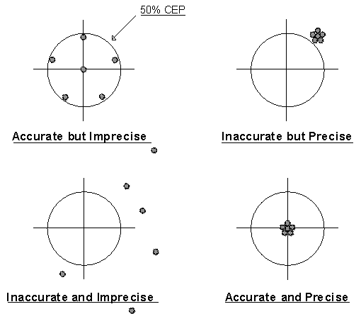
An accurate and precise weapon system is a team effort between the developer and DMA.
9. Pseudo Accuracy. A related problem arises from our unquestioning assumptions about high technology. DoD plans to buy up to 95,000 Precise Lightweight Geopositional Receivers (PLGR) at $1,300 each for a diversity of applications. PLGR is hand held and weighs 2.75 pounds. It can receive both levels of GPS accuracy, the best accuracy being 16 meters SEP (50%). However, PLGR can display coordinates in whole degrees, whole minutes, and seconds to two decimal places. Trigonometry tells us that .01 arc seconds of latitude is equal to about 31 centimeters on the earth. When you are using WVS for mission planning, remember it has a specification accuracy no better than 500 meters (or 50,000 centimeters) no matter what the displayed precision of the coordinates suggests! The moral of these examples is that display precision can mislead warfighters about source data accuracy.
Use of the most powerful hardware and software in the world to exploit MC&G data will not improve the original accuracy of that data, and can make it worse!
10. Datums. In the past warfighters didn’t worry much about datums. Older datums were acceptably accurate only within a particular local geographic region, like Europe or North America, because of the earth’s imperfect shape. Now DoD weapon systems need precise, highly accurate datums and the equally accurate coordinates that come from them. An in-depth understanding of datums is essential. A lack of understanding could easily cause mission failure!
A datum is a math model of the Earth’s shape used as a basic reference to calculate position coordinates, heights, and distances, and also to make maps. The datum is the origin or point of reference.
The only way you can know the datum of a paper map is by a careful reading of the margin information!
The only way you can know the datum of digital data is by a careful reading of the header information!
The only way you can know the unspecified datum of coordinates given to you is to ask!
Hundreds of different datums exist worldwide. Consider them all "apples and oranges." Always talk about the same datum when communicating. Precise target locations depend on it.
11. WGS 84. World Geodetic System 1984 (WGS 84) is the official DoD positional reference system. (WGS 84 replaces its predecessor systems WGS 60, WGS 66, and WGS 72.) WGS 84 is a unified earth-centered model of the globe based on improved geometric, geodetic, and gravity information. WGS 84 relates positions on those other datums to a single interoperable standard. Some older datums have lost their accuracy, some because plate tectonic activity has physically moved permanent survey marks once precisely placed! DMA continues to update the constants needed to transform between one datum and another and to derive new constants when necessary. Excluding the datums already tied to WGS 84, several hundred other obscure ones exist that don’t have transformation constants.
When you convert poorly known coordinates from another datum to WGS 84, you still have poorly known coordinates!
Some deployed weapon systems have hard wired specific or nonstandard datums that are less accurate than WGS 84. For example, the B-1B has avionics hard wired to WGS 72. Early models of the F-15 had systems referenced to North American Datum 1927. Early models of the F-16 referenced the European Datum (their expected area of operation). The UH-60 and the AH-64 reference six ellipsoids and not WGS at all. Unfortunately, no one explained this to the aviators in their flight manuals and there are no plans to retrofit.
In Korea, the current local datum is the Tokyo Datum. The datum shift to WGS 84 in this area averages about 750 meters!
Different datums will give different coordinates for the same target!
Many existing DMA paper products are still in distribution (mostly reprints and maps made by foreign countries) that are not on WGS 84.
12. Datum Transformation and Coordinate Conversion. Errors accumulate every time you transform from one datum or grid to another, even if using DMA-approved MADTRAN software. The WGS 84 technical report is the authoritative source for these transformation constants.
The minimum degradation of position using WGS 84 transformation constants is two meters for each transformation.
13. The Global Positioning System. Any DoD weapon system using GPS, or in development to use GPS, will require MC&G combat support from DMA, directly or indirectly. Why? Because GPS is the DoD standard navigation system. It provides a common, highly precise spatial reference to warfighters continuously in real time anywhere in the world. And the GPS reference frame is WGS 84. GPS supplies three-dimensional position, velocity, and time information in all weather.
GPS has profound applications for weapon guidance, bomb on coordinates, enroute navigation, mission planning, target acquisition, command and control, Unmanned Aerial Vehicle (UAV) operations, search and rescue, photo reconnaissance, range instrumentation, and precise target locations.
GPS accuracy is usually better than maps by several orders of magnitude. The difference increases as map scale decreases. However, this is not to say that since warfighters now have GPS, they don’t need maps!
If you have GPS, you still need MC&G products and services for referencing and positioning.
GPS provides two different levels of accuracy. With Precise Positioning Service, full accuracy is 10 meters CEP (50%) or 16 meters SEP (50%). (Note that 16 meters at 50% equates to a PLGR display accuracy no better than .5 arc seconds.) This encrypted signal limits access to DoD.
With Standard Positioning Service, the accuracy is 40 meters CEP (50%). This signal is primarily for the civil community, but DoD can downgrade it in a crisis. (Note that 40 meters at 50% equates to a PLGR display accuracy no better than one arc second.)
GPS receivers give warfighters the option to output elevations and coordinates on many grids and datums, including WGS 84. Just because they are "coordinates from GPS" do not assume they necessarily meet the GPS accuracy.
Accuracy depends on the original source of the coordinates, not the display device!
GPS goes in most of the Naval aviation fleet: EA-6B, SH-60D, SH-60F, C/KC-130, E-2C, E-6A, ES-3A, CH-53E, MH-53E, P-3C, EP-3, VH-60, and JPATS. The Miniature Airborne GPS Receiver (MAGR) goes in the AV-8B, F-14A/B, F-14D, F/A-18A/B, F/A-18C/D, F/A-18E/F, S-3B, and V-22A. The Embedded GPS Receiver (EGR) goes in the AH-1W.
The Standoff Land Attack Missile (SLAM) and Tomahawk Land Attack Missile (TLAM) will have integrated GPS receivers. The Tomahawk Baseline Improvement Program (TBIP) will use a seeker and GPS. It will not need Digital Scene Mapping and Correlation (DSMAC) or Terrain Contour Matching (TERCOM).
JDAM will be a launch and leave autonomous weapon EGR coupled to an Inertial Measurement Unit (IMU). The upgrade to JDAM will add a terminal seeker. JSOW will combine GPS with INS.
The Combat Survivor Evader Locator (CSEL) is a GPS receiver mated to a non-voice satellite communications radio. It reports your position automatically to SAR units when you are down behind enemy lines. CSEL eliminates visual searching or voice communications and their vulnerability to monitoring by the enemy. CSEL makes "Beam me up, Scotty" a near reality for those warfighters temporarily stranded with an unequal number of takeoffs and landings.
14. Precise Target Coordinate Sources. Not too long ago, maps were the basic frames of reference for position. There was nothing better. Now, maps and their raster derivatives are unsuitable for targeting! Does this mean give maps the heave ho? No. Just use them differently as the frame of reference for the more accurate GPS position.
Don’t degrade the delivery accuracy of your weapon system by using coordinates that are less accurate than your system permits!
Reliable target coordinates come only from a limited number of classified sources:
DMA Points Program. This is your source for the most accurate WGS 84 coordinates achievable. DMA accepts requests for precise positions via secure phone, secure fax, or classified message. DMA has to identify the target positively, so they will need from you a brief description, a line drawing or photo, coordinates for reference, and your authorized justification code. Routine requests take 30 days, but may be preempted by higher priority. In a crisis, however, turnaround is as quick as two hours. They give coordinates horizontal and vertical accuracy at 90% probability.
APPS. Navy users can derive their own precise positions using the Analytical Photogrammetric Positioning System (APPS) and hard copy PPDB imagery, even when deployed afloat. APPS requires a skilled operator. Digital PPDBs will begin to replace the hard copy in FY96. The Navy system to use DPPDB will be the Digital Image Workstation (DIWS).
When working with coordinates, receiving coordinates, or passing coordinates, always know the source of the coordinates and the datum!
WGIS Retrieval. The World Geodetic Information System (WGIS) is a PC software application developed by DMAAC and available to you. It allows you to retrieve previously mensurated precise positions from two classified data bases of published aim points. They are the World Aim Point Catalog (WAPC) and the North American Aim Point Catalog (NAPC). Warfighters can add additional aim points to these data bases. WGIS will also list the GNC, JNC, ONC, TPC, and JOG charts covering your aim points and all aim points in these data bases along your specified flight path or geographic area.
BC = CMF
Bad Coordinates equal Combat Mission Failure
15. Complete Position Reporting. When reporting position coordinates from paper products JCS requires you also provide the datum, a description of the product (series, sheet number, edition, date), and who produced it. If you are reporting position coordinates derived from non-paper products such as the APPS and GPS receivers, JCS requires you provide the datum, who derived the coordinates, the method used, and the accuracy of the coordinates. And if you are, say, providing close air support, we know you’ll be sure you get the same information.
Where to find it:
(
Order DoD WGS 84 from DMA and ask for DMATR83502WGS84. Remember it includes MADTRAN. ( Order Coordinate Selection Guide from DMA using stock number DIAXXCOORDGRAPH. ( Order Geodesy For the Layman from Defense Technical Information Center, Attn: BCR, Bldg. 5, Cameron Station, Alexandria VA 22304 or call (703) 274-7633 ext 9307 [DSN 284] and ask for DMATR80-003. ( To get DMA precise points for the first time, seek assistance from your MC&G Team at (703) 604-4000 extensions 2917 or 2909 [DSN 664]. ( To get WGIS talk to Mr. Wiley at DMAAC, (314) 263-4133 [DSN 693] or write to DMAAC, Attn: SDF, 3200 S. Second St., St. Louis MO 63118.Section VIII
Keeping Up With MC&G Progress
1. Sources Of Information.
Your MC&G Team in Air-4.5. System developers will benefit from routine contact with the DMA Liaison Officer and METOC Officer in Air-4.5. We are there to help you. We have authoritative information about the latest MC&G developments.
Navy/Marine Corps MC&G Working Group. N096 chairs this group. It meets about once a quarter to exchange timely information on relevant MC&G topics. It’s open to all members of the TEAM, including field activities, and contractors. Contact your MC&G Team in Air-4.5 to get on the meeting notification list.
MC&G Conference. This annual DoD MC&G conference is a forum for the principal MC&G officers from the Unified Commands, Services, and certain Federal agencies. They address MC&G issues, problems, and activities of mutual interest. The conference report summarizes presentations, discussions, new action items, and status of previous action items. "Report of the 1994 Mapping, Charting, and Geodesy Fall Conference," 12-14 October 1994, is a record of the last conference. The main conference is in the fall (usually at Ft. Belvoir), with a smaller one in the spring (usually at Headquarters, DMA). It’s the one place to go to find out all the latest stuff DMA is doing for the warfighter. Conference attendance is by invitation only. If you need to attend as a non-voting observer, see your DMA Liaison Officer. These conference reports have limited distribution, so contact your MC&G Team if you want to see one.
2. Another Peek At The Future. The explosion of commercial digital technology, new customer expectations, fiscal constraints, and revolutionary MC&G technical developments are forcing DMA to change. DMA is transforming itself from a product factory to a provider of information about the earth. GGI&S is the natural consequence of this explosion. GGI&S will collect, map, and distribute global geospatial information, and related services, and deliver them on-line from an electronic gateway with bulletin board access. This will allow customers, worldwide, to push or pull MC&G information on demand through Internet and Intelink. The information will be accurate, precise, current, and referenced to WGS 84 in a coherent structure that is part of the NSDI. The Defense Information Systems Agency (DISA) will manage the data communications networks used by GGI&S. DMA customers of GGI&S – the warfighters of the future – will have unprecedented access to digital information that describes the earth in such detail that they can get equally unprecedented knowledge of battle spaces, any time, anywhere. GGI&S will assure the interoperability of joint weapon systems and reduce the cost of unique MC&G solutions. TEAM system developers will participate intimately in the creation of GGI&S. Six GGI&S pilot projects begin in FY95. The future of MC&G is GGI&S, plain and simple.
3. New DMA Initiatives. Many new DMA initiatives are in the works now that system developers need to know about in the near term.
• More Accurate Targeting. GPS guided weapons, JDAM, JSOW, and Tomahawk (Block III, IV) will need enhanced positioning support. The near and long term accuracy objectives of DMA’s Precise Positioning Initiative allow aircraft and weapons to navigate more accurately than currently possible. Expect accomplishment of the near term objective in November 1995 and the long term objective in 1999-2000.
• Faster Targeting. Near real-time distribution of precise point coordinates to warfighters is a DMA technical objective for FY00.
• Synthetic Aperture Radar. DMA, the Advanced Research Projects Agency (ARPA), and others are validating the Interferometric Synthetic Aperture Radar (IFSAR) system as a source for advanced MC&G capabilities.
• Interoperable Map Software. DMA initiated the DoD Interoperable Map Software Program to develop and distribute software supporting standardized exploitation of geospatial data. DISA and DMA now coordinate the development of new general purpose and analytical software tools standardized for interoperability. In FY97, DMA will begin certifying reusable MC&G software for the Defense Software Repository System. By FY00, DMA will deliver a certified software package, the Joint Mapping Toolkit, to the Global Command and Control System (GCCS) for visual and analytical map capabilities and MC&G spatial database management.
• GPS. COMSAT (Commercial Satellite) Augmented GPS (CAG) is under consideration for dual use, military and civilian. CAG will add GPS to commercial satellites in geosynchronous orbit to improve availability and vertical accuracy. CAG will be available for all users with an accuracy of 3-5 meters SEP, almost ILS Category 1 precision.
• High Resolution Terrain. The Defense Modeling and Simulation Office recently designated DMA as the DoD M&S single focal point for reusable high resolution terrain data bases for operational planning and mission rehearsal. In this context, terrain representation includes data, models of natural and man-made dynamic processes, and cultural features. This "electronic sand table" promises to be the background for the virtual battle space of the future. Terrain fidelity, feature content, resolution, and accuracy are issues requiring further definition. DMA will coordinate requirements, standards, research, development, and production of these interoperable data bases. DMA’s new Terrain Modeling Project Office has an action to demonstrate an initial capability by FY96 to produce – within one week – standard terrain data with a nominal 2500 km
2 area.• New Training Products. Defense Mapping School will produce a brochure and a video to help educate and explain problems associated with datums as well as a reference work on GPS modeled after the classic "Geodesy For the Layman." In addition, DMS is actively looking into interactive multimedia training and distance learning applications. At the request of warfighters they plan to offer a Coordinate Workshop to examine actual DoD targeting problems.
• MC&G Distribution. DMA is integrating MC&G product distribution into the Defense Logistics Standards System to use fully its information and transportation assets. DMA will convert its stock numbers to National Stock Numbers (NSNs). This will allow warfighters to use their existing logistics systems and make it much easier to get DMA products.
• Remote Replication System. DMA recently started a capability to use DMA digital data to print locally, on demand, a few near lithographic quality paper products using electrostatic printers. This will meet the quick response needs of planners during crisis while DMA prints and distributed conventional lithographic quantities. It prints 24 by 26 inch products at 60 copies per hour and 54 by 60 inch products at 12 copies per hour at $5-10 per copy depending on size. The Norfolk, Virginia test site is operational; however, the final hardware design probably won’t be suitable for extreme environments such as shipboard use.
• Product Evaluation Handbook. This DMA publication will improve the formal process DMA uses to evaluate MC&G products for routine updating. The evaluation process is essentially a life cycle maintenance concept based on the intended uses of the products. DMA uses two criteria: the positional accuracy of the current product and the currency of product content. This publication tells system developers how often DMA plans to produce new editions of products and the existing MC&G products DMA will not maintain. Expect availability of this handbook in FY95.
• New MC&G Standards. DMA has a Vector Product Format Standard, a Raster Product Format Standard, and a Text Product Format Standard in various stages of development.
- Vector Product Format Development Program. VPF will provide a family of thematically organized digital data bases of low, medium, and high resolution. They will include such things as hydrography, shorelines, elevation, vegetation data, lines of transportation, aeronautical information, names data, and viewing software. The data format standardizes digitizing conventions, tiling, feature attribution, and feature coding. The standard medium will be CD-ROM. These data bases will support GIS analysis for command, control, and intelligence and also terrain analysis, mission planning and rehearsal, and modeling and simulation, and will support maritime navigation.
- Raster Product Format Development Program. RPF will provide a family of digital products in a standardized format to support spatial referencing and background displays. Key considerations will be storage format, digitizing conventions, tiling schemes, spatial accuracy, and speed of display. Raster products will come from existing paper products and digital imagery. RPF data files will be fully compliant with the National Imagery Transmission Format (NITF) standard.
- Text Product Format Development Program. This format closely follows the Continuous Acquisition and Life Cycle Support (CALS)/Standard Graphics Markup Language (SGML) industry standard. Text applications of interest to NAVAIR developers include a Digital Gazetteer and Digital CHUM for distribution electronically and on CD-ROM.
4. Developmental Products And Services. Here are some DMA MC&G products and services system developers can expect to work with in the future.
• Improvements to WGS 84. DMA continuously updates and improves parameters for transforming local geodetic datums to WGS 84. DMA and NASA are improving the Earth Gravity Model (EGM) and the geoid. The geoid heights in WGS 84 currently have a one sigma error range of ±2 to ±6 meters. In mid 1996, DMA will define a new world height vertical reference standard for use in DoD systems development. The expected error range is less than one meter.
• Unified Grid System. The DIA/DMA Coordinates Working Group is considering a Unified Grid System to resolve interoperability problems in the battle space caused by the current Military Grid Reference System (MGRS) and the UTM grid.
• DFAD. Attributes of Digital Feature Analysis Data, DMA’s oldest digital feature product, is under evaluation for inclusion in VMap 1.
• CADRG. Compressed ARC Digitized Raster Graphic is a compressed and reduced version of ADRG in the RPF. The ADRG gets filtered and down sampled before compression. The resulting pixel spacing is 150 microns (169 DPI) as opposed to the 100 microns (254 DPI) of ADRG. The data then gets compressed using a Vector Quantization (VQ) technique. The final step in the production of CADRG reduces the 24-bit RGB color of the ADRG (16.7 million possible combinations) to an 8-bit indexed RGB color table (216 colors). Each step in the process causes some data loss and prevents exact recovery of the original data from the compressed product. The resulting CADRG data file has a 55:1 compression ratio. CADRG is the DoD standard for mission planning and cockpit displays. Production began in January 1995. Expect complete worldwide coverage by the end of FY95.
• CIB. Controlled Image Base is a seamless, compressed broad area image product in Raster Product Format made from various imagery sources. Mission planning and C
3I systems will use CIB. Warfighters can also use it as a map background, a registration base for other products (since DMA has geocoded and orthorectified it), and as an image map when better cartographic products are not available. Unlike CADRG, CIB has no spatial reduction. No color reduction is necessary because the image is panchromatic. The only compression losses are due to the VQ process. The compression ratio is approximately 8:1. Initial production started in February 1995 using 10 meter SPOT imagery. Worldwide coverage is a goal, but limited source availability and the extensive volume required make 100 percent coverage unlikely.• DCW. Digital Chart of the World became available in 1992 as the proof of concept for VPF. DCW has 17 thematic layers and an index of 100,000 place names. It is a public sale item from USGS. Global coverage can be yours for only $200. Although technically VPF compliant, the DCW format differs in several ways from the current VPF. VMap Level 0 will replace DCW in 1995.
• DNC. Digital Nautical Chart is a VPF compliant product containing the significant maritime features found on paper nautical charts. DNC production began in 1993. Expect worldwide coverage in 1997 for maritime navigation and combat support systems.
• WVS Plus. WVS Plus improves the original World Vector Shoreline product for use in command and control and mission planning. It adds political and maritime boundaries. DMA generalizes the data as scale decreases from 1:250,000 to 1:120,000,000. Three of the scale choices include low resolution bathemetry. Initial production begins in October 1995.
• ITD. Interim Terrain Data is a vector product designed for Army and Marine Corps terrain analysts. It incorporates all the information found in hard copy Tactical and Planning Terrain Analysis Databases including slope, vegetation, surface material, drainage, transportation, and obstacle data. DTED Level 1 coverage is included with the data base. Originally in Standard Linear Format, existing ITD will convert to VPF and will be the basis for Digital Terrain Analysis Data (DTAD) production.
• TTD. Tactical Terrain Data is a new composite product combining DTED Level 2 with DTAD and DNC.
• Vector Smart Map. VMap is a family of VPF data bases with standard thematic content at different resolutions. VMap is useful for GIS analysis and as background data for other layers of information added by warfighters. Some are now in production. A VPF Data Sampler is available on CD-ROM. It also includes WVS, DNC, and VPF View software.
- VMap 0. The data in Vector Smart Map Level 0 is similar to the content found on 1:1,000,000 scale charts. This product contains no aeronautical information. VMap 0 is the follow on product to DCW.
- VMap 1. The data in Vector Smart Map Level 1 is similar to the content found on 1:250,000 scale Joint Operations Graphics. This product contains no aeronautical information. There will be worldwide coverage.
- VMap 2. The data in Vector Smart Map Level 2 is similar to the content found on 1:50,000 scale Topographic Line Maps.
- UVMap. The Urban Vector Smart Map uses DMA City Graphics as source, not photos. It provides high resolution data with rich feature attribution suitable for intelligence applications. This product’s geodetic accuracy will not support targeting.
• VMap AD. VMap Aeronautical Data is a VPF product that provides information similar to that found in the aeronautical overprint on paper charts and in Vertical Obstruction Data. This product supplements VMap 0 and VMap 1 products since they don’t contain aeronautical information.
• DFLIP. Digital FLIP prototype development is underway. DFLIP will support mission planning, 2D and 3D electronic cockpit displays, and a paperless cockpit. It will be in Vector Product Format. Users are evaluating a second prototype. IOC is FY99. Eventually, DFLIP may incorporate VMap AD as a data subset.
• DG. Digital Gazetteer contains information about the location and names of features and places. It will be in VPF on CD-ROM and will include DIGIGAZVIEW utility software. Initial production commences in FY95.
• ECHUM. This Electronic Chart Updating Manual is a digital text file accessible from DMA by modem that lists corrections to DMA charts since their publication. It draws from the same data base used to produce the hard copy CHUM. You select a flight corridor, area about a point, or a specific chart; then ECHUM delivers just those related corrections. It is much faster and easier to read than the CHUM document. ECHUM updates its data base at the beginning of each month and has the most up-to-date information on the current edition of DMA products. After about a year of operation, ECHUM has more than 300 registered users. Users can provide comments on ECHUM through an on-line mailbox. ECHUM will test a new methodology to update CADRG automatically.
• NAVINFONET. The DMA Navigation Information Network provides 24-hour electronic access to worldwide maritime safety information. Like ECHUM, all you need is a microcomputer, modem, and communications software. Although primarily focused on marine use, NAVINFONET contains data files useful to naval aviation. It is the only source for current positions of mobile offshore drilling units. It provides status and general information on GPS, Differential GPS, Omega, and Loran-C using data from the US Coast Guard Navigation Center. NAVINFONET also furnishes status and information on a variety of other radio navigation aids. The Anti-Shipping Activity Message file gives you the latest on pirates in the area, who sometimes shoot at low flying aircraft. NAVINFONET positions in the above files are geographic coordinates on the datum of the original source.
• DMA Modernized Catalog. DMA is developing a single modernized catalog system in soft copy and hard copy versions that will provide a better portrayal of available products and contain up-to-date product description information. You will follow simple ordering procedures from a personal computer and enjoy remote access and on-line updates. The catalog standardizes content by regions of the world, not product types. Each region will stand alone. The new catalog will be available on CD-ROM in both classified and unclassified versions. Scheduled delivery to customers is early 1996.
• DPPDB. Digital Point Positioning Database is a classified data base of high resolution digital stereo image pairs. DPPDB accurately geopositions any targets locatable anywhere within the image. This will replace the existing film-based PPDB. The DPPDB compressed imagery complies with RTF and NITF. Production begins in November 1995. DMA will provide exploitation software; however, customers will purchase the workstation hardware.
• MUSE 1.1. Expect the first revision to MUSE around April 1995. It fixes some pesky minor bugs and runs on two new UNIX platforms: Hewlett Packard and Silicon Graphics. The big changes are an improved raster import function and new support for the ARC Standard Raster Product (ASRP) from the United Kingdom. This support removes the previous "Distribution Limited" caveat and all distribution restrictions. MUSE 1.1 also comes with an improved manual.
• MUSE 2.0. MUSE 2.0 is due for release around September 1995. It will support additional international products and Windows NT. It will also have a more sophisticated symbol set for vector products using an industry standard format called Computer Graphics Metafile (CGM). MUSE 2.0 will add a set of annotation, drawing, and mensuration tools to its present fusion capability. These tools will compute distance, bearing, area, and airspace volume in a variety of units and display the annotated results on digital maps supported by MUSE. Users can save the output, print, and trasmit electronically. The tools have broad application for geospatial allocation of all kinds of assets or resources (humanitarian relief, disaster containment, etc.). They are equally useful for analyzing and reporting the results of that allocation. This requirement originated last year with a TEAM naval aviator who needed a fast, accurate, and automated way of computing P-3 search areas. His initial contact with his DMA Liaison Officer started the ball rolling.
Where to find it:
(
The MC&G conference reports are available from your MC&G Team at (703) 604-4000 ext 2917. ( The data structure standards are available from TeleSpecs at the Defense Printing Service, (215) 697-1187 [DSN 442]. ( To get your ECHUM user ID and manual, call the DMAAC ECHUM Liaison, Shelley Weiss, at (314) 263-4005 [DSN 693]. ( For access to NAVINFONET, call A DMAHTC NAVINFONET System Manager at (301) 227-3296 [DSN 287]. ( For information on MC&G developmental products contact Mr. Harden or LCDR Willis in Air-4.5 at (703) 604-4000 ext 2909 [DSN 664].Section IX
Measuring DMA Combat Support Performance
1. The Need. Budget realities are driving all of us interested in MC&G to be more effective and to work together at unprecedented levels of complexity within a more interoperable infrastructure. In turn, DMA needs to know from TEAM customers, in practical ways, how well they are doing and how they can specifically improve. DMA improvement eventually translates into lower unit cost, broader geographical coverage, and more accurate MC&G data for the warfighter.
2. Customer Service Measurement. For the first time, DMA conducted a rigorous statistical survey to measure customer satisfaction and identify opportunities for improvement. The survey went to 1,171 customers (an 11% sample). About 13% of the customers were system developers (including contractors), and over one-fourth of these answered. Overall customer satisfaction was 84%. The biggest problems were the difficulty in gaining access to DMA products and services and their timely receipt. As a result, DMACSC customer service reorganized along regional lines to serve warfighters better. DMA will annually survey customers to measure progress against this baseline.
3. Quality Feedback. Quality is what the customer says it is. To DMA quality is fitness for use; i. e., the degree to which MC&G products and services meet the needs and exceed the expectations of warfighters. Experts tell us that, whatever the product or service, you can describe fitness for use with three basic measures: quantity, quality, and timeliness.
We all know that things left to themselves don’t get right. Until you acknowledge a problem, no solution is needed. We can’t improve something until we know it needs fixing. It’s not always obvious, so how do you know when there is a problem?
A problem exists anytime there is a difference between what IS and what OUGHT TO BE.
The most important part of every DMA production process is feedback from customers. For you – oh, busy and important warfighter and system developer – this is an easy thing to delegate to others, or defer indefinitely. After all, everyone knows that DMA products are the best available. Anyway, DMA has no competition. Moreover, DMA products are free. So, why not take DMA for granted?
When was the last time you washed a rental car?
Why bother with talking to DMA? Why not just grab a map and go? The answer is that MC&G products are critical to your mission success and your personal safety. You and DMA can’t wait until something goes wrong. The name of the MC&G quality game is PREVENTION.
DMA wants to hear from any customers by any means on any topics related to MC&G. In particular, they need to know how MC&G products and services perform in actual operational use – the ultimate reality check. (This also applies to prototypes during development.)
All DMA paper products have a note in the margin asking for additions, corrections, comments or questions along with a return address. Historically, very few customers respond to this note, if they notice it at all.
So, DMA developed the Quality Feedback Card (QFC). DMA Form 8560-1 is a prepaid business reply postcard that gives warfighters a quicker and easier way to tell DMA about the fitness for use of any MC&G product or service.

DMA believes that DMA responsiveness to customer expectations directly relates to customer confidence in MC&G products and services. Every card submitted gets a DMA reply. DMA collects and analyzes QFC data to measure satisfaction and dissatisfaction with MC&G product and service performance and to make subsequent process improvements.
Experts say that customers initiate about 80% of all product innovations. DMA simply has no substitute for the unique ideas of warfighters and developers like you. Use whatever method is easiest for you (QFC, telephone, visits with the DMA Liaison Officer, etc.) so long as you DO IT!
Just thinking about improving DMA products and services has the same result as not thinking about it.
4. Joint Teams. Both DMA and the TEAM are using Total Quality Leadership as their primary means for doing better with fewer resources. It makes good strategic sense to each organization. Both have a successful track record with internal TQ team efforts. The next logical step is a team of map makers and system developers working together for mutual benefit. Your MC&G Team wants to nominate an appropriate pilot project and they want some proposals from you. To get you going, consider the following question.
What is impossible to do today, but if done by the TEAM and DMA, would fundamentally improve your operations?
The MC&G Team in Air-4.5 wants to hear from you.
Where to find it:
(
QFCs are available in tear out form in DMA Catalogs, FLIPs, and the CHUM. All map shipments contain loose, blown in QFCs.Acknowledgments
This handbook owes its inspiration to the original MC&G Handbook put together by the DMA Liaison Officer to Air Force Material Command, Gary Hacker, and the MC&G Officer, Maj Mike Papirtis, USAF. We plagiarized without remorse from their handbook and elsewhere, and when we thought it would help TEAM readers, made improvements along the way.
We would like to thank Mr. Tom Klocek of MITRE for material taken from his paper MAPS: Myth and Reality presented at the Automated Mission Planning Conference in March 1994.
Ms. Bobbie Lenczowski, the champion of GGI&S, USAF Capt Wes Baker, from DMS, Dr. Bill Wooden, the DMA Headquarters GPS guru, and Ms. Cindy Burns of DMACSC took the time for careful review of early drafts and we appreciate their improvements.
LCDR Karl Dinkler at DMA provided a much needed customer preview of both versions.
Special thanks go to Mr. Stu Coleman at DMA for coordinating a careful update of the summary statistics in Appendix C and to all the DMA program managers who provided those important numbers.
Lars Issa of Decision Systems Technologies, Inc. created the snazzy TEAM cover logo that looks even better in full color. Thanks, Lars.
However, every error belongs to us.
So, how did we do? Does this handbook add any value to your work? Do you think it was worth the effort? Can you tell us how to make it better?
Thanks for your comments, questions, and improvements. Keep sending them to:
LCDR Zdenka S. Willis Air-4.5M Williszs.ntrprs@navair.navy.mil
or
John H. Harden, Jr. Air-4.5D Hardenjh.ntrprs@navair.navy.mil
We haven’t exhausted our supply of seals yet, so our original offer still stands: in return for comments, we’ll send you a durable 2-inch DMA color seal (while our supply lasts). It shows your commitment to DoD interoperability and looks neat on planners and notebooks!
Appendix A
Key MC&G Players
|
Name |
Address |
Phone |
Remarks |
|
LCDR Zdenka S. Willis |
Commander Naval Air Systems Command (Code Air-4.5M) Naval Air Systems Command Headquarters 1421 Jefferson Davis Highway Arlington VA 22243-5120 |
703-604-4000 ext 2909 fax 604-4448 [DSN 664] |
TEAM METOC Officer |
|
Mr. Jay Harden |
Commander Naval Air Systems Command (Code Air-4.5D) Naval Air Systems Command Headquarters 1421 Jefferson Davis Highway Arlington VA 22243-5120 |
703-604-4000 ext 2917 fax 604-4448 [DSN 664] |
DMA Liaison Officer to TEAM |
|
CAPT Mike Hacunda Ms. Mary Clawson |
Office of the Oceanographer, N096 3450 Massachusetts Avenue, NW Washington DC 20392-5421 |
202-653-1610 [DSN 294] |
CNO sponsor |
|
Mr. Ed Danford |
Office of the Oceanographer CNO N961CD (Ed Danford) 3450 Massachusetts Avenue, NW Washington DC 20392-5421 |
202-653-1610 [DSN 294] |
DMA Liaison Officer to Navy |
|
Ms. Beverly Mitchell |
Space and Naval Warfare Systems Command (Code 30D) 2451 Crystal Drive Arlington VA 22245 |
703-602-1203 [DSN 332] |
DMA Liaison Officer to SPAWAR |
|
Mr. Kurt Savoie |
Marine Corps Intelligence Activity Attn: DMALO MCIA 13 2033 Barnett Avenue Quantico VA 22134-5011 |
703-784-2234 fax 784-2026 [DSN 278] |
DMA Liaison Officer to USMC |
|
Maj Bobby Mosley |
Marine Corps Intelligence Activity Attn: DMALO MCIA-13 2033 Barnett Avenue Quantico VA 22134-5011 |
703-784-2234 fax 784-2026 [DSN 278] |
Marine Corps MC&G Officer |
|
Mr. Bill McMahon |
U. S. Army Corps of Engineers Topographic Engineering Center Attn: CETEC-PD-D 7701 Telegraph Road Alexandria VA 22315 |
703-355-2804 [DSN 345] |
DMA Liaison Officer to TEC |
|
Mr. John Arensberg |
Electronic Systems Center Attn: DMALO 5 Eglin Street Hanscom AFB MA 01731-2123 |
617-377-8368 [DSN 478] |
DMA Liaison Officer to ESC |
|
Mr. Gary Hacker |
Headquarters, Air Force Material Command Attn: IN(DMALO) 4225 Logistics Avenue, Suite 11 Wright Patterson AFB OH 45433 |
513-257-5047 [DSN 787] |
DMA Liaison Officer to AFMC |
|
QMCS John Gray |
Pentagon Office DMA Combat Support Center Pentagon Room BG720 Washington DC 20301-7000 |
703-695-7907 [DSN 225] |
DMA Pentagon Office |
|
Ms. Lynn Keleher |
Defense Mapping School 5825 21st Street Suite 106 Ft. Belvoir VA 22060 |
703-805-3213 [DSN 655] |
DMS Registrar |
|
Mr. Kevin Shaw Ms. Maura Lohrenz |
Naval Research Laboratory Mapping, Charting, and Geodesy Branch (Code 7441) Stennis Space Center MS 39529-5004 |
601-688-4611 [DSN 485] |
Navy lab |
|
Mr. Mark Wonnacott |
Naval Air Warfare Center Weapons Division (Code C-2876) 1 Administration Circle China Lake CA 93555-6001 |
619-939-1089 [DSN 437] |
Weapons Division |
|
LCDR John Scanlan |
JAST Program Office (Code JAST-RQN1) 1215 Jefferson Davis Highway, Suite 800 Arlington VA 22202-3251 |
703-602-7390 ext 6650 [DSN 664] |
Joint Advanced Strike Technology |
|
LCDR Randy Mahr |
Program Executive Office (Code PMA-201E11) Tactical Aircraft Programs 1421 Jefferson Davis Highway Arlington VA 22243-5120 |
703-604-2410 ext 4892 [DSN 664] |
Conventional Strike Weapons |
|
Ms. Phyllis Corley |
Commander Naval Air Systems Command (Code PMA-2053B2) Naval Air Systems Command Headquarters 1421 Jefferson Davis Highway Arlington VA 22243-5120 |
703-604-2245 ext 3072 [DSN 664] |
Aviation Training Systems TOP SCENE |
|
Mr. Roger Logan |
Commander Naval Air Systems Command (Code PMA-209G) Naval Air Systems Command Headquarters 1421 Jefferson Davis Highway Arlington VA 22243-5120 |
703-604-0903 ext 3732 [DSN 664] |
Air Combat Electronics |
|
MAJ Al Womble |
Program Executive Office (Code PMA-233D) Tactical Aircraft Programs 1421 Jefferson Davis Highway Arlington VA 22243-5120 |
703-604-1450 ext 8446 [DSN 664] |
Tactical Aircraft Mission Planning System |
|
LCDR Matt Scassero |
Program Executive Office (Code PMA-23441) Tactical Aircraft Programs 1421 Jefferson Davis Highway Arlington VA 22243-5120 |
703-604-2540 ext 4832 [DSN 664] |
A-6/EA-6 |
|
Ms. Laurie Godschall |
Commander Naval Air Systems Command (Code Air-4.5.7) Naval Air Systems Command Headquarters 1421 Jefferson Davis Highway Arlington VA 22243-5120 |
703-604-4000 ext 2956 [DSN 664] |
AV8-B |
|
LCDR Jeff Sherman |
Commander Naval Air Systems Command (Code PMA-2613) Naval Air Systems Command Headquarters 1421 Jefferson Davis Highway Arlington VA 22243-5120 |
703-604-2480 ext 7053 [DSN 664] |
H-53 and Executive Transport Helicopters |
|
LCDR Dan Canin |
Commander Naval Air Systems Command (Code Air-4.5.7) Naval Air Systems Command Headquarters 1421 Jefferson Davis Highway Arlington VA 22243-5120 |
703-604-2210 ext 4468 [DSN 664] |
F/A-18 |
|
LCDR Don Mueller |
Commander Naval Air Systems Command (Code Air-4.5.1.2) Naval Air Systems Command Headquarters 1421 Jefferson Davis Highway Arlington VA 22243-5120 |
703-604-2440 ext 5230 [DSN 664] |
V-22A |
|
Ms. Wanda Green |
Commander Naval Air Systems Command (Code Air-4.5.1.2) Naval Air Systems Command Headquarters 1421 Jefferson Davis Highway Arlington VA 22243-5120 |
703-604-4000 ext 2951 [DSN 664] |
AH-1 |
|
Mr. Paul Coakley |
Program Executive Officer Cruise Missiles Project and Unmanned Aerial Vehicles Joint Project (Code PMA-28135) Naval Air Systems Command Headquarters 1213 Jefferson Davis Highway Arlington VA 22202 |
703-604-1706 [DSN 664] |
Cruise Missile Command and Control System |
|
Mr. John Misenheimer |
Commander Space and Naval Warfare Systems Command (Code PMW/PMA-177) 2451 Crystal Drive Arlington VA 22245-5200 |
703-604-5191 [DSN 664] |
Navigation Systems |
|
Mr. Tracy Murrel |
Commander Naval Air Systems Command (Code Air-4.5.3) Naval Air Systems Command Headquarters 1421 Jefferson Davis Highway Arlington VA 22243-5120 |
703-604-3180 ext 2642 [DSN 664] |
Tactical Aircraft Moving Map |
|
Dr. William McCanless |
Commander Naval Air Systems Command (Code PMA-248A) Naval Air Systems Command Headquarters 1421 Jefferson Davis Highway Arlington VA 22243-5120 |
703-604-1414 ext 8414 [DSN 664] |
JTCTS |
Appendix B
Matrix Of TEAM Customers And DMA Products
An effective weapon system is a joint effort between developers and DMA. This appendix is the latest compilation of TEAM programs and the MC&G products they use. Does it list your system?
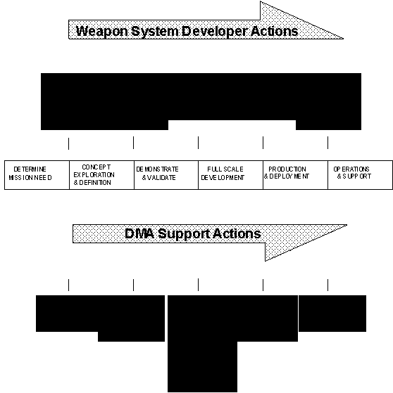
|
TEAM |
Acronym |
Program |
Product(s) |
Milestone |
Status |
Remarks |
|
PEO(JAST) |
JAST |
Joint Advanced Strike Technology |
DTED |
|
|
Joint (USN lead) |
|
PMA-201 |
JSOW |
Joint Standoff Weapon Baseline |
DTED Points DPPDB |
2 |
ORD |
Joint GPS |
|
PMA-201 |
JDAM |
Joint Direct Attack Munitions |
Points DPPDB |
1 |
ORD |
Joint (USN lead) GPS |
|
PMA-205 |
|
Aviation Training Systems |
|
|
|
|
|
PMA-205 |
TOP SCENE |
Tactical Operational Preview Scene |
DTED PPDB |
|
|
|
|
PMA-209 |
TAMM ATIMS |
Tactical Aircraft Moving Map |
CADRG CIB DTED |
|
MNS |
|
|
PMA-231 |
ATDS |
E-2 Aircraft Tactical Display System |
DTED DCW |
|
|
GPS |
|
PMA-233 |
TAMPS |
Tactical Aircraft Mission Planning System |
CADRG DTED1 WVS DAFIF ADRG ADRI CIB DNC DCW |
3 |
ORD |
TMTK |
|
PMA-234 |
TEAMS |
Tactical EA-6B Mission Support System |
DTED1 ADRG DAFIF CADRG |
1 |
|
GPS |
|
PMA-248 |
JTCTS |
Joint Tactical Combat Training System |
DTED1 DTED2 DFAD1 DFAD1C DFAD2 DFAD3C DBDB PVOD WVS ITD TTD |
1 |
ORD |
Joint GPS |
|
PMA-257 |
AV-8B |
AV-8B Targeting System |
CAC |
|
MNS |
GPS |
|
PMA-261 |
CH-53 |
CH-53 Midlife Upgrade |
Points |
|
ORD |
GPS |
|
TEAM |
Acronym |
Program |
Product(s) |
Milestone |
Status |
Remarks |
|
PMA-265 |
|
Low Altitude Terrain Following/Terrain Clearance Navigation Capability for F/A-18 |
DTED1 CAC |
|
MNS draft |
|
|
PMA-265 |
F/A-18E/F |
F/A-18E/F |
CIB CAC CADRG DTED1 |
NA |
ORD |
M2:FY96Q2 GPS/INS or MAGR |
|
PMA-273 |
JPATS |
Joint Primary Aircraft Training System |
DTED1 |
1 |
ORD |
Joint (USAF lead) GPS |
|
PMA-273 |
T45TS |
T-45 Training System |
|
|
|
GINA |
|
PMA-275 |
V-22A |
V-22A Osprey |
DTED1 CADRG CIB |
1 |
|
M2:FY94Q4 |
|
PMA-276 |
AH-1W |
AH-1W Midlife Upgrade |
CADRG CIB DTED1 |
NA |
ORD |
EGR |
|
PMA-280 |
TBIP |
Tomahawk Weapon System Baseline Improvement Program |
DPPDB Points |
2 |
ORD |
GPS |
|
PMA-281 |
JSIPS |
Joint Service Imagery Processing System |
DTED1 WMED DPPDB ADRG CADRG |
2 |
ORD draft |
Joint (USAF lead) |
|
PMA-281 |
MDS/MDDS |
Mission Display System/Mission Data Distribution System |
VOD ADRG WVS |
|
|
TMPCU |
|
PMA-281 |
TDDS |
Tactical Data Distribution System |
VOD |
|
|
APS |
|
PMA-281 |
DIWS DIWS-A |
Digital Image Workstation Suite (Afloat) |
DPPDB TERCOM |
|
|
TMPCU APS |
|
PMA-281 |
TSCM |
Tomahawk Strike Coordination Module |
ADRG WVS |
|
|
|
|
PMA-281 |
TPS TPS-A |
Tomahawk Land Attack Missile Planning System (Afloat) |
DTED VOD WVS TERCOM |
|
|
TMPCU APS |
|
PMA-290 |
P-3 GPS |
P-3 Global Positioning System |
Points |
3 |
|
datums, coordinate systems, accuracies |
|
PMA-299 |
VH-60N |
VH-60N Midlife Upgrade |
DAFIF |
|
ORD |
GPS |
|
PMW/ PWA-159 |
JTIDS |
Joint Tactical Information Distribution System |
|
2 |
|
|
|
TEAM |
Acronym |
Program |
Product(s) |
Milestone |
Status |
Remarks |
|
PMW/ PWA-177 |
PLGR |
Precise Lightweight Geopositional Receiver |
Points |
3 |
|
GPS, datums, coordinate systems, accuracies |
|
PMW/ PWA-177 |
CSEL |
Combat Survivor Evader Locator |
Points |
1 |
|
GPS datums, coordinate systems, accuracies |
|
PMW/ PWA-177 |
GPS |
Global Positioning System |
Points |
3 |
|
|
|
PMW/ PWA-177 |
MAGR |
Miniature Airborne Global Positioning System |
Points |
3 |
|
|
Appendix C
Useful Statistics About Selected DMA Products
Standard Products
[Some statistics are representative values for purposes of comparison.]
|
Product |
GNC |
JNC |
ONC |
TPC |
Coastal Chart |
JOG-A |
TLM |
|
Output unit |
chart |
chart |
chart |
chart |
chart |
chart |
chart |
|
Medium |
paper |
paper |
paper |
paper |
paper |
paper |
paper |
|
Scale |
1:5M |
1:2M |
1:1M |
1:500K |
1:300K |
1:250K |
1:50K (7) |
|
Digital storage |
NA |
NA |
NA |
NA |
NA |
NA |
NA |
|
Data density |
NA |
NA |
NA |
NA |
NA |
NA |
NA |
|
One inch = |
416,667 feet |
166,667 feet |
83,333 feet |
41,667 feet |
25,000 feet |
20,883 feet |
4,167 feet |
|
Average size in x in |
42 x 57 |
42 x 57 |
42 x 57 |
42 x 57 |
24 x 35 |
22 x 29 |
22 x 29 |
|
Average size nm x nm |
2,400 x 3,650 |
960 x 1,460 |
480 x 730 |
240 x 340 |
121 x 177 |
60 x 90 |
15 x 15 |
|
Average snm |
876,000 |
1.4M |
350,400 |
81,600 |
21,417 |
5,400 |
190 |
|
Equivalent # 1:50K TLM (1) |
44,800 |
7,168 |
1,792 |
448 |
93 |
32 |
1 |
|
Print quantity |
40,000 |
17,000 |
50,000 |
50,000 |
1,500 |
16,000 |
5,900 |
|
Labor cost new product |
NA |
NA |
1,500 hours |
1,999 hours |
1,450 hours |
1,800 hours |
850 hours |
|
Labor cost (revision) |
876 hours |
619 hours |
512 hours |
476 hours |
300 hours |
771 hours |
450 hours |
|
Calendar days new product |
NA |
NA |
502 |
436 |
270 |
591 |
476 |
|
Calendar days (revision) |
255 |
240 |
245 |
259 |
120 |
519 |
257 |
|
Abs Horiz Accuracy |
32,805 feet |
13,123 feet |
6,561 feet |
3,280 feet |
300 meters |
125 meters |
50 meters |
|
Abs Vertical Accuracy |
NA |
1,000 feet |
500 feet |
250 feet |
.3 meters |
25-100 meters |
10-40 meters |
|
Rel Horiz Accuracy |
8,333 feet |
3,333 feet |
1,667 feet |
833 feet |
NA |
NA |
NA |
|
Rel Vertical Accuracy |
NA |
1,000 feet |
500 feet |
250 feet |
NA |
NA |
NA |
|
Required earth coverage (2) |
100% (4) |
100% (5) |
100% (6) |
76% |
27% |
22% |
3% |
|
Available earth coverage (3) |
100% |
100% |
100% |
61% |
26% |
17% |
2% |
(1) This allows comparison among products by converting to an equivalent standard, the 1:50,000 Topographic Line Map, which is DMA’s most accurate large scale paper product that is available generally worldwide.
(2) The percent of the total earth’s surface (148,705 ksnm) the warfighter needs mapped.
(3) The percent of the total earth’s surface (148,705 ksnm) currently available to the warfighter.
(4) 27 charts cover the total earth’s surface.
(5) 122 charts cover the total earth’s surface.
(6) 270 charts cover the total earth’s surface.
(7) Also available at 1:100,000 (statistics are for 1:50,000).
|
Product |
Combat Chart |
City Graphic |
DTED Level 1 |
DTED Level 2 |
DFAD Level 1 E2 |
VOD |
ITD |
|
Output unit |
chart |
chart |
1º cell |
15' cell |
1º cell |
1º cell |
15' cell |
|
Medium |
paper |
paper |
CD-ROM |
9 track CCT |
9 track CCT |
9 track CCT |
9 track CCT |
|
Scale |
1:50K |
1:12.5K (1) |
1:250K (equiv) |
1:50K (equiv) |
1:250K (equiv) |
1:250K (equiv) |
1:50K (equiv) |
|
Digital storage |
NA |
NA |
2.9 MB |
27 MB |
12 MB |
|
6 MB (4) |
|
Data density |
NA |
NA |
403 pts/snm |
3620 pts/snm |
1.5 features/snm |
|
varies (5) |
|
One inch = |
4,167 feet |
1,042 feet |
varies (2) |
varies (2) |
varies (2) |
varies (2) |
4,167 feet |
|
Average size in x in |
33 x 45 |
34 x 44 |
NA |
NA |
NA |
NA |
22 x 29 |
|
Average size nm x nm |
27 x 32 |
12 x 7 |
37 x 60 |
15 x 15 |
37 x 60 |
37 x 60 |
15 x 13 |
|
Average snm |
864 |
89 |
2,220 |
225 |
2,220 |
2,220 |
190 |
|
Equivalent # 1:50K TLM |
4 |
<1 |
16 |
4 |
16 |
16 |
1 |
|
Print quantity |
7,000 |
2,500 |
NA |
NA |
NA |
NA |
NA |
|
Labor cost new product |
1085 hours |
1,171 hours |
700 hours |
550 hours |
1,143 hours |
492 hours |
1,725 hours |
|
Labor cost (revision) |
NA |
800 hours |
NA |
NA |
NA |
NA |
NA |
|
Calendar days new product |
352 |
613 |
235 |
371 |
200 |
154 |
344 |
|
Calendar days (revision) |
NA |
369 |
NA |
NA |
NA |
NA |
NA |
|
Abs Horiz Accuracy |
50 meters |
25 meters |
50 meters |
50 meters |
130 meters |
classified |
50 meters |
|
Abs Vertical Accuracy |
40 meters |
10 meters |
30 meters |
30 meters |
10 meters |
NA |
10-40 meters |
|
Rel Horiz Accuracy |
NA |
NA |
NA |
NA |
NA |
NA |
NA |
|
Rel Vertical Accuracy |
NA |
NA |
NA |
NA |
NA |
NA |
NA |
|
Required earth coverage |
.22% |
.14% |
27% (3) |
NA |
13% |
|
.19% |
|
Available earth coverage |
.22% |
.08% |
18% |
NA |
4% |
|
.15% |
(1) Also available at 1:25,000.
(2) Depending on display.
(3) This is 100% of the earth’s land mass, or about 19,000 1º cells worldwide.
(4) This includes the entire ITD data set.
(5) Same as TTADB and PTADB.
|
Product |
TERCOM Landfall |
TERCOM Enroute |
TERCOM Terminal |
PPDB Film |
Gridded Airfield Photo |
APG |
Points |
|
Output unit |
cell |
cell |
cell |
film pairs floppy disk |
photo |
cell |
coordinate pair |
|
Medium |
9 track CCT |
9 track CCT |
9 track CCT |
hard copy software package |
photo |
photo |
text |
|
Scale |
classified |
classified |
classified |
1:110,000 (1) |
1:6,000 |
1:15,000 |
NA |
|
Digital storage |
98 MB |
48 MB |
39 MB |
NA |
NA |
NA |
NA |
|
Data density |
classified |
classified |
classified |
NA |
NA |
NA |
NA |
|
One inch = |
classified |
classified |
classified |
9,167 feet |
500 feet |
1,250 feet |
NA |
|
Average size in x in |
classified |
classified |
classified |
8.5 x 11 |
20 x 24 |
5 x 5 |
NA |
|
Average size nm x nm |
classified |
classified |
classified |
60 x 60 |
2 x 2 |
1 x 1 |
NA |
|
Average snm |
classified |
classified |
classified |
3,600 |
4 |
1.25 |
NA |
|
Equivalent # 1:50K TLM |
classified |
classified |
classified |
5 |
<1 |
<1 |
NA |
|
Print quantity |
NA |
NA |
NA |
30 |
15 |
6 |
NA |
|
Labor cost new product |
525 hours |
198 hours |
160 hours |
275 hours |
60 hours |
16 hours |
5 hours |
|
Labor cost (revision) |
NA |
NA |
NA |
NA |
NA |
NA |
NA |
|
Calendar days new product |
477 |
249 |
214 |
NA |
90 |
60 |
10 |
|
Calendar days (revision) |
NA |
NA |
NA |
NA |
NA |
NA |
NA |
|
Abs Horiz Accuracy |
classified |
classified |
classified |
classified |
classified |
classified |
classified |
|
Abs Vertical Accuracy |
classified |
classified |
classified |
classified |
classified |
classified |
classified |
|
Rel Horiz Accuracy |
classified |
classified |
classified |
classified |
classified |
classified |
classified |
|
Rel Vertical Accuracy |
classified |
classified |
classified |
classified |
classified |
classified |
classified |
|
Required earth coverage |
NA |
NA |
NA |
14% |
varies |
classified |
classified |
|
Available earth coverage |
NA |
NA |
NA |
7% |
NA |
classified |
classified |
(1) Also available at 1:80,000 and 1:300,000.
|
Product |
FLIP (1) |
DAFIF (1) |
ADRG (2) |
DCW (3) |
DNC |
WVS |
WMED |
|
Output unit |
text graphics |
text records |
chart |
4 CD-ROM (4) |
29 CD-ROM |
5º x 5º tile set |
WAG cell |
|
Medium |
hard copy |
9 track CCT |
CD-ROM |
CD-ROM |
CD-ROM |
CD-ROM |
9 track CCT |
|
Scale |
varies |
NA |
varies (6) |
1:1M (equiv) |
1:50K - 1:500K (equiv) |
1:250K (equiv) various (7) |
NA |
|
Digital storage |
NA |
<5 MB |
600 MB |
6.8 GB |
10 GB |
106 MB (1:250K) |
<5 MB |
|
Data density |
NA |
NA |
254 pixels/inch |
varies |
varies |
12 pts/nm |
2 elevations /cell (4) |
|
One inch = |
NA |
NA |
varies (5) |
varies (5) |
varies (6) |
varies |
NA |
|
Average size in x in |
varies |
NA |
NA |
NA |
varies (6) |
NA |
NA |
|
Average size nm x nm |
varies |
NA |
varies (6) |
NA |
varies (6) |
varies |
12 x 18 |
|
Average snm |
NA |
NA |
varies (6) |
148,700 K |
varies (6) |
NA |
216 |
|
Equivalent # 1:50K TLM |
NA |
NA |
varies (6) |
NA |
varies (6) |
NA |
NA |
|
Print quantity |
NA |
NA |
NA |
NA |
NA |
NA |
NA |
|
Labor cost new product |
NA |
NA |
35 hours |
contract |
500 hours |
NA |
6 hours |
|
Labor cost (revision) |
NA |
NA |
NA |
NA |
TBD |
NA |
TBD |
|
Calendar days new product |
(1) |
(1) |
90 |
NA |
30 |
NA |
NA |
|
Calendar days (revision) |
NA |
NA |
NA |
NA |
TBD |
NA |
TBD |
|
Abs Horiz Accuracy |
varies |
NA |
varies (6) |
6,700 feet |
varies (6) |
500 meters |
NA |
|
Abs Vertical Accuracy |
varies |
NA |
varies (6) |
2,000 feet |
varies (6) |
NA |
varies |
|
Rel Horiz Accuracy |
varies |
NA |
varies (6) |
varies (6) |
varies (6) |
NA |
NA |
|
Rel Vertical Accuracy |
varies |
NA |
varies (6) |
varies (6) |
varies (6) |
NA |
NA |
|
Required earth coverage |
NA |
NA |
100% |
100% |
66% |
100% of shorelines |
100% |
|
Available earth coverage |
NA |
NA |
varies (8) |
100% |
0% |
100% of shorelines |
100% |
(1) Updated every 28 days.
(2) NRL transforms ADRG into CAC to support the AV-8B and F/A-18. DMA assumes this responsibility in FY96.
(3) DCW is the first DMA product to support GIS and comes with VPFVIEW software.
(4) One minimum elevation and one maximum elevation per cell.
(5) Depending on display.
(6) See original paper product.
(7) Additional scales available are 1:1M, 1:3M, 1:12M, 1:40M, 1:120M.
(8) Depending on scale.
Developmental Products
|
Product |
CADRG |
CIB |
VMAP Level 0 |
VMAP Level 1 |
VMAP Level 2 |
Digital PPDB |
|
Output unit |
chart |
1º cell |
4 CD-ROM (1) |
1º tile |
15' tile |
1º ZDR |
|
Medium |
CD-ROM |
CD-ROM |
CD-ROM |
CD-ROM |
CD-ROM |
8 mm tape cartridge |
|
Scale |
varies |
1:75,000 |
1:1M (equiv) |
1:250K (equiv) |
1:50K-1:100K (equiv) |
1:110,000 |
|
Digital storage |
600 MB (3) |
13 GB |
1.7 GB (1) |
|
|
26 GB (2) |
|
Data density |
169 pixels/inch |
TBD |
varies |
varies |
varies |
NA |
|
One inch = |
varies |
NA |
varies |
varies |
varies |
NA |
|
Average size in x in |
NA |
NA |
NA |
NA |
NA |
NA |
|
Average size nm x nm |
varies |
60 x 60 |
NA |
60 x 60 |
varies |
60 x 60 |
|
Average snm |
varies |
3,600 |
varies |
varies |
varies |
3,600 |
|
Equivalent # 1:50K TLM |
varies |
NA |
NA |
720 |
16 |
5 |
|
Print quantity |
NA |
NA |
10,000 |
2,500 |
2,500 |
TBD |
|
Labor cost new product |
800 hours |
125 hours |
contract |
6,850 hours |
6,850 hours |
22 hours |
|
Labor cost (revision) |
NA |
TBD |
TBD |
TBD |
TBD |
NA |
|
Calendar days new product |
100 |
TBD |
TBD |
273 |
273 |
TBD |
|
Calendar days (revision) |
NA |
TBD |
TBD |
TBD |
TBD |
NA |
|
Abs Horiz Accuracy |
varies |
<61 meters |
6,561 feet |
125-500 meters |
50-200 meters |
classified |
|
Abs Vertical Accuracy |
varies |
NA |
500 feet |
.5-2 contours |
.5-2 contours |
classified |
|
Rel Horiz Accuracy |
varies |
<61 meters |
NA |
NA |
NA |
classified |
|
Rel Vertical Accuracy |
varies |
NA |
NA |
NA |
NA |
classified |
|
Required earth coverage |
100% |
100% |
100% |
|
|
10% |
|
Available earth coverage |
varies (4) |
1% |
0% |
|
|
0% |
|
IOC |
Apr 95 |
Jan 95 |
Jan 95 |
Oct 94 |
Oct 94 |
Nov 95 |
(1) For the 4 CD-ROMs of 273 vectorized ONCs worldwide.
(2) Equals 4 GB compressed.
(3) About 5,000 ADRG charts compressed to approximately 150 CD-ROMs.
(4) Depending on availability of ADRG.
Paper Chart Scales & Equivalents
(1)|
|
MILES PER INCH |
INCHES PER MILE |
|
||||
|
SCALE |
NAUTICAL |
STATUTE |
NAUTICAL |
STATUTE |
FEET PER INCH |
||
|
1:12,500 |
0.17 |
0.20 |
5.83 |
5.07 |
1,041.67 |
||
|
1:25,000 |
0.34 |
0.40 |
2.92 |
2.53 |
2,083.33 |
||
|
1:50,000 |
0.69 |
0.79 |
1.46 |
1.27 |
4,166.67 |
||
|
1:100,000 |
1.37 |
1.58 |
0.73 |
0.63 |
8,333.33 |
||
|
1:200,000 |
2.74 |
3.16 |
0.36 |
0.32 |
16,666.67 |
||
|
1:250,000 |
3.43 |
3.95 |
0.29 |
0.25 |
20,833.33 |
||
|
1:500,000 |
6.86 |
7.89 |
0.15 |
0.13 |
41,666.67 |
||
|
1:1,000,000 |
13.72 |
15.78 |
0.07 |
0.06 |
83,333.33 |
||
|
1:2,000,000 |
27.43 |
31.57 |
0.04 |
0.03 |
166,666.67 |
||
|
1:3,000,000 |
41.15 |
47.35 |
0.02 |
0.02 |
250,000.00 |
||
|
1:5,000,000 |
68.58 |
78.91 |
0.01 |
0.01 |
416,666.67 |
||
(1)
When you zoom in on a digitally scanned paper chart (at any scale) you magnify it and change the scale even though the information content remains unchanged!
The Pitfalls Of Paper
|
PAPER CHART LINE WEIGHTS |
||||||
|
SCALE |
WIDTH OF PENCIL |
GROUND DISTANCE |
||||
|
1:12,500 |
0.5 mm |
625 mm |
6.25 meters |
|||
|
1:25,000 |
0.5 mm |
1,250 mm |
12.5 meters |
|||
|
1:50,000 |
0.5 mm |
2,500 mm |
25 meters |
|||
|
1:100,000 |
0.5 mm |
5,000 mm |
50 meters |
|||
|
1:200,000 |
0.5 mm |
10,000 mm |
100 meters |
|||
|
1:250,000 |
0.5 mm |
12,500 mm |
125 meters |
|||
|
1:500,000 |
0.5 mm |
25,000 mm |
250 meters |
|||
|
1:1,000,000 |
0.5 mm |
50,000 mm |
500 meters |
|||
|
1:2,000,000 |
0.5 mm |
100,000 mm |
1000 meters |
|||
|
1:3,000,000 |
0.5 mm |
150,000 mm |
1500 meters |
|||
|
1:5,000,000 |
0.5 mm |
250,000 mm |
2500 meters |
|||
Paper maps depict the world exactly as it exists, don’t they? Well, actually they don’t. Hmm, so what does this say about map accuracy? Take a look at the above table. While the math seems obvious, the inference is not. For example, take a road, the levee beneath it, and the shore line they define. All appear in the same physical space when seen from directly overhead. (Cartographers call this the planimetric or plan view, as opposed to a perspective view.) If faithfully positioned at 1:250,000 scale, the mapped road, levee, and shore line visually interfere with each other and are indistinguishable. For a line weight on the map of .5 mm, cartographers can’t show objects at this scale with closer spacing than 125 meters. To make the product useful for the warfighter, map makers must displace these features from their true position and may generalize their shape so they appear visually distinct and clear. Displacement and generalization, often not obvious to the warfighter, along with the map scale and projection influence the way maps appear and, more important, the way maps should be used. Map information must be altered and filtered out according to the purpose of the map. A tourist map of Washington, D.C., for example, doesn’t need the terrain shown on a topographic map. In fact, fictitious terrain detail may be added simply for a pleasing effect. These liberties of mapmaking science play havoc with precise feature positions taken from maps. Paper charts can be your worst enemy for determining coordinates such as target locations – don’t do it!
The Water And Land Masses Of The Earth
|
TOTAL WATER |
103,833 |
KSNM |
69.8 % |
|
|
|
|
|
|
ASIA |
14,548 |
KSNM |
9.8 % |
|
AUSTRALIA |
2,237 |
KSNM |
1.5 % |
|
GREENLAND |
633 |
KSNM |
.4 % |
|
AFRICA |
8,829 |
KSNM |
5.9 % |
|
ANTARCTICA |
4,525 |
KSNM |
3.0 % |
|
NORTH AMERICA |
7,059 |
KSNM |
4.7 % |
|
SOUTH AMERICA |
5,191 |
KSNM |
3.5 % |
|
EUROPE |
804 |
KSNM |
.5 % |
|
OTHER |
1,046 |
KSNM |
.7 % |
|
|
|
|
|
|
TOTAL LAND |
44,872 |
KSNM |
30.1 % |
|
|
|
|
|
|
WORLD TOTAL |
148,705 |
KSNM |
100.0 % |
The Coastlines Of The Countries
There are about 174,055 nautical miles of coastline worldwide. (Hmm…but if you’re into fractals, the answer is….)
Appendix D
Accuracy And Positional Error
This Appendix will show you how to convert linear, circular, and spherical accuracy statements for positional error. You can go from one percent probability to another within the same statistical distribution.
Accuracy. Accuracy is a statistical measure of performance. In naval aviation, we mean the accuracy of our navigation and positioning systems – maps to avionics. Accuracy is a meaningless measure by itself unless it also includes a statement of the uncertainty of the measure. The uncertainty is the percent probability that the errors will not exceed a certain amount. The uncertainty accounts for only known, predictable errors. (Unfortunately, it's quite impossible to include the unanticipated, incomprehensible, and really stupid things we humans from time to time do with our systems – present company excluded, of course!)
Assumptions. Note the following critical assumptions. Errors in vertical position will follow a normal linear distribution. Errors in geodetic position will follow a normal circular distribution. Errors in spatial position will follow a normal spherical distribution. The summary statistics in this appendix assume only random errors are present. They are not valid for samples biased by systematic errors or blunders. Relative accuracy considers only random errors. Absolute accuracy considers random and systematic errors; however when the data set is on a common datum then we assume that we have removed all systematic error (bias).
Warning. You can unintentionally misuse the Selected Conversion Factors and Standard Error Increments when you incorrectly apply the associated theory and assumptions. To make competent program decisions commensurate with risk, use the appropriate technical references.
Using The Selected Conversion Factors
To convert from one percent probability to another in the same distribution, multiply the "from" row by the conversion factor intersecting the "to" column.
For example: Which is more accurate, 45 feet circular error at 90% probability or 25 feet circular error at 50% probability? Find the intersection of the 90% row and the 50% column in the circular distribution table to get the conversion factor 0.5486. Multiply 45 by 0.5486 to get 24.687. Because 45 feet CMAS (90%) = 24.7 feet CEP (50%), which is less than 25 feet CEP, the 90% circular error is slightly more accurate. Yep, if you had that urge to push the envelope and instead used the 50% row and 90% column you would multiply 1.8227 by 25 and get 45.567 confirming that the 90% error of 45 feet is still the better accuracy.
|
|
|
SELECTED CONVERSION FACTORS |
||||||||||||
|
|
|
LINEAR (ONE DIMENSION) DISTRIBUTION |
||||||||||||
|
from |
to |
LEP 50% |
LMSE 57.51% |
1s 68.27% |
MAS 90% |
NATO 95% |
2s 95.45% |
LNCE 99.73% |
||||||
|
LEP |
50% |
1.1830 |
1.4826 |
2.4387 |
2.9059 |
2.9652 |
4.4477 |
|||||||
|
LMSE |
57.51% |
0.8453 |
1.2533 |
2.0615 |
2.4564 |
2.5066 |
3.7599 |
|||||||
|
1s |
68.27% |
0.6745 |
0.7979 |
1.6449 |
1.9600 |
2.0000 |
3.0000 |
|||||||
|
MAS |
90% |
0.4101 |
0.4851 |
0.6079 |
1.1916 |
1.2159 |
1.8238 |
|||||||
|
NATO |
95% |
0.3441 |
0.4071 |
0.5102 |
0.8392 |
1.0204 |
1.5306 |
|||||||
|
2s |
95.45% |
0.3373 |
0.3990 |
0.5000 |
0.8225 |
0.9800 |
1.5000 |
|||||||
|
LNCE |
99.73% |
0.2248 |
0.2660 |
0.3333 |
0.5483 |
0.6533 |
0.6667 |
|||||||
|
LEP |
Linear Error Probable |
|
LMSE |
Linear Mean Square Error |
|
1 s |
One Sigma (Standard Error) |
|
MAS |
Linear Map Accuracy Standard |
|
NATO |
North Atlantic Treaty Organization preferred |
|
2 s |
Two Sigma |
|
LNCE |
Linear Near Certainty Error (3 s) |
|
|
|
SELECTED CONVERSION FACTORS |
||||||||||||||
|
|
|
CIRCULAR (TWO DIMENSION) DISTRIBUTION |
||||||||||||||
|
from |
to |
1s 39.35% |
CEP 50% |
CMSE 63.21% |
2s 86.47% |
CMAS 90% |
NATO 95% |
3s 98.89% |
CNCE 99.78% |
|||||||
|
1s |
39.35% |
1.1774 |
1.4142 |
2.0000 |
2.1460 |
2.4477 |
3.0000 |
3.5000 |
||||||||
|
CEP |
50% |
0.8493 |
1.2011 |
1.6987 |
1.8227 |
2.0789 |
2.5480 |
2.9727 |
||||||||
|
CMSE |
63.21% |
0.7071 |
0.8326 |
1.4142 |
1.5175 |
1.7308 |
2.1213 |
2.4749 |
||||||||
|
2s |
86.47% |
0.5000 |
0.5887 |
0.7071 |
1.0730 |
1.2239 |
1.5000 |
1.7500 |
||||||||
|
CMAS |
90% |
0.4660 |
0.5486 |
0.6590 |
0.9320 |
1.1406 |
1.3979 |
1.6309 |
||||||||
|
NATO |
95% |
0.4085 |
0.4810 |
0.5778 |
0.8171 |
0.8767 |
1.2256 |
1.4299 |
||||||||
|
3s |
98.89% |
0.3333 |
0.3925 |
0.4714 |
0.6667 |
0.7153 |
0.8159 |
1.1667 |
||||||||
|
CNCE |
99.78% |
0.2857 |
0.3364 |
0.4041 |
0.5714 |
0.6131 |
0.6993 |
0.8571 |
||||||||
|
1s |
One Sigma (Circular Standard Error) |
|
CEP (1) |
Circular Error Probable |
|
CMSE (2) |
Circular Mean Square Error |
|
2 s |
Two Sigma |
|
CMAS |
Circular Map Accuracy Standard |
|
NATO |
North Atlantic Treaty Organization preferred |
|
3 s |
Three Sigma |
|
CNCE |
Circular Near Certainty Error (3.5 s) |
(1) You may know CEP as Circle of Equal Probability, and Circular Probable Error (CPE).
(2) You may know CMSE as Mean Square Positional Error (MSPE).
|
|
|
SELECTED CONVERSION FACTORS |
||||||||||||||
|
|
|
SPHERICAL (THREE DIMENSION) DISTRIBUTION |
||||||||||||||
|
from |
to |
1s 19.9% |
SEP 50% |
SMSE 60.82% |
2s 73.8% |
SAS 90% |
NATO 95% |
3s 97.1% |
SNCE 99.89% |
|||||||
|
1s |
19.9% |
1.5382 |
1.7321 |
2.0000 |
2.5003 |
2.7955 |
3.0000 |
4.0000 |
||||||||
|
SEP |
50% |
0.6501 |
1.1260 |
1.3002 |
1.6255 |
1.8174 |
1.9503 |
2.6004 |
||||||||
|
SMSE |
60.82% |
0.5774 |
0.8881 |
1.1547 |
1.4435 |
1.6140 |
1.7321 |
2.3094 |
||||||||
|
2s |
73.8% |
0.5000 |
0.7691 |
0.8660 |
1.2502 |
1.3978 |
1.5000 |
2.0000 |
||||||||
|
SAS |
90% |
0.4000 |
0.6152 |
0.6927 |
0.7999 |
1.1181 |
1.1999 |
1.5998 |
||||||||
|
NATO |
95% |
0.3577 |
0.5502 |
0.6196 |
0.7154 |
0.8944 |
1.0732 |
1.4309 |
||||||||
|
3s |
97.1% |
0.3333 |
0.5127 |
0.5774 |
0.6667 |
0.8334 |
0.9318 |
1.3333 |
||||||||
|
SNCE |
99.89% |
0.2500 |
0.3846 |
0.4330 |
0.5000 |
0.6251 |
0.6989 |
0.7500 |
||||||||
|
1s |
One Sigma (Spherical Standard Error) |
|
SEP (1) |
Spherical Error Probable |
|
SMSE (2) |
Spherical Mean Square Error |
|
2 s |
Two Sigma |
|
SAS |
Spherical Accuracy Standard |
|
NATO |
North Atlantic Treaty Organization preferred |
|
3 s |
Three Sigma |
|
SNCE |
Spherical Near Certainty Error (4 s) |
(1) You may know SEP as Spherical Probable Error (SPE).
(2) You may know SMSE as Mean Radial Spherical Error (MRSE).
Using Other Conversion Factors
If you want to convert between probabilities not in the above tables, you must first compute the unique conversion factor that applies. From the appropriate distribution column in the following table divide the "to" standard error increment by the "from" standard error increment to get the desired conversion factor, then continue as above.
For example: What is 47 feet CMAS (90%) at 75% probability? Divide the 75% error increment of 1.6651 by 2.1460 (the increment for 90%) to get the conversion factor .7759. Multiply 47 by .7759 to get the answer of 36.47 feet.
|
Standard Error Increments (1) |
||||||||||||||||||||
|
linear |
circular |
spherical |
linear |
circular |
spherical |
|||||||||||||||
|
distribution |
distribution |
distribution |
distribution |
distribution |
distribution |
|||||||||||||||
|
PRECISION INDEX |
PRECISION INDEX |
|||||||||||||||||||
|
probability |
probability |
|||||||||||||||||||
|
0% |
0.0000 |
0.0000 |
0.0000 |
56% |
0.7722 |
1.2814 |
1.6436 |
|||||||||||||
|
1% |
0.0123 |
0.1418 |
0.3389 |
57% |
0.7892 |
1.2992 |
1.6616 |
|||||||||||||
|
2% |
0.0251 |
0.2010 |
0.4299 |
LMSE |
57.51% |
0.7979 |
||||||||||||||
|
3% |
0.0376 |
0.2468 |
0.4951 |
58% |
0.8064 |
1.3172 |
1.6797 |
|||||||||||||
|
4% |
0.0502 |
0.2857 |
0.5479 |
59% |
0.8239 |
1.3354 |
1.6980 |
|||||||||||||
|
5% |
0.0627 |
0.3203 |
0.5932 |
60% |
0.8416 |
1.3537 |
1.7164 |
|||||||||||||
|
6% |
0.0753 |
0.3518 |
0.6334 |
SMSE |
60.82% |
1.7321 |
||||||||||||||
|
7% |
0.0878 |
0.3810 |
0.6699 |
61% |
0.8596 |
1.3723 |
1.7351 |
|||||||||||||
|
8% |
0.1004 |
0.4084 |
0.7035 |
62% |
0.8779 |
1.3911 |
1.7540 |
|||||||||||||
|
9% |
0.1130 |
0.4343 |
0.7349 |
63% |
0.8965 |
1.4101 |
1.7730 |
|||||||||||||
|
10% |
0.1257 |
0.4590 |
0.7644 |
CMSE |
63.21% |
1.4142 |
||||||||||||||
|
11% |
0.1383 |
0.4828 |
0.7924 |
64% |
0.9154 |
1.4294 |
1.7924 |
|||||||||||||
|
12% |
0.1510 |
0.5056 |
0.8192 |
65% |
0.9346 |
1.4490 |
1.8119 |
|||||||||||||
|
13% |
0.1637 |
0.5278 |
0.8447 |
66% |
0.9542 |
1.4689 |
1.8318 |
|||||||||||||
|
14% |
0.1764 |
0.5492 |
0.8694 |
67% |
0.9741 |
1.4891 |
1.8519 |
|||||||||||||
|
15% |
0.1891 |
0.5701 |
0.8932 |
68% |
0.9945 |
1.5096 |
1.8724 |
|||||||||||||
|
16% |
0.2019 |
0.5905 |
0.9162 |
Linear 1 s |
68.27% |
1.0000 |
||||||||||||||
|
17% |
0.2147 |
0.6105 |
0.9386 |
69% |
1.0152 |
1.5305 |
1.8932 |
|||||||||||||
|
18% |
0.2275 |
0.6300 |
0.9605 |
70% |
1.0364 |
1.5518 |
1.9144 |
|||||||||||||
|
19% |
0.2404 |
0.6492 |
0.9818 |
71% |
1.0581 |
1.5735 |
1.9360 |
|||||||||||||
|
Spherical 1 s |
19.9% |
1.0000 |
72% |
1.0803 |
1.5956 |
1.9580 |
||||||||||||||
|
20% |
0.2533 |
0.6680 |
1.0026 |
73% |
1.1031 |
1.6182 |
1.9804 |
|||||||||||||
|
21% |
0.2663 |
0.6866 |
1.0230 |
Spherical 2 s |
73.8% |
2.0000 |
||||||||||||||
|
22% |
0.2792 |
0.7049 |
1.0430 |
74% |
1.1264 |
1.6414 |
2.0034 |
|||||||||||||
|
23% |
0.2924 |
0.7230 |
1.0627 |
75% |
1.1503 |
1.6651 |
2.0269 |
|||||||||||||
|
24% |
0.3055 |
0.7409 |
1.0821 |
76% |
1.1750 |
1.6894 |
2.0510 |
|||||||||||||
|
25% |
0.3186 |
0.7585 |
1.1012 |
77% |
1.2004 |
1.7145 |
2.0757 |
|||||||||||||
|
26% |
0.3319 |
0.7760 |
1.1200 |
78% |
1.2265 |
1.7402 |
2.1012 |
|||||||||||||
|
27% |
0.3451 |
0.7934 |
1.1386 |
79% |
1.2536 |
1.7667 |
2.1274 |
|||||||||||||
|
28% |
0.3585 |
0.8106 |
1.1570 |
80% |
1.2816 |
1.7941 |
2.1544 |
|||||||||||||
|
29% |
0.3719 |
0.8276 |
1.1751 |
81% |
1.3106 |
1.8225 |
2.1825 |
|||||||||||||
|
30% |
0.3853 |
0.8446 |
1.1932 |
82% |
1.3408 |
1.8519 |
2.2114 |
|||||||||||||
|
31% |
0.3989 |
0.8615 |
1.2110 |
83% |
1.3722 |
1.8825 |
2.2416 |
|||||||||||||
|
32% |
0.4125 |
0.8783 |
1.2288 |
84% |
1.4051 |
1.9145 |
2.2730 |
|||||||||||||
|
33% |
0.4261 |
0.8950 |
1.2464 |
85% |
1.4395 |
1.9479 |
2.3059 |
|||||||||||||
|
34% |
0.4399 |
0.9116 |
1.2638 |
86% |
1.4758 |
1.9830 |
2.3404 |
|||||||||||||
|
35% |
0.4538 |
0.9282 |
1.2812 |
Circular 2 s |
86.47% |
2.0000 |
||||||||||||||
|
36% |
0.4677 |
0.9448 |
1.2985 |
87% |
1.5141 |
2.0200 |
2.3767 |
|||||||||||||
|
37% |
0.4817 |
0.9613 |
1.3158 |
88% |
1.5548 |
2.0593 |
2.4153 |
|||||||||||||
|
38% |
0.4959 |
0.9778 |
1.3330 |
89% |
1.5982 |
2.1011 |
2.4563 |
|||||||||||||
|
39% |
0.5101 |
0.9943 |
1.3501 |
MAS, CMAS, SAS |
90% |
1.6449 |
2.1460 |
2.5003 |
||||||||||||
|
Circular 1 s |
39.35% |
1.0000 |
91% |
1.6954 |
2.1945 |
2.5478 |
||||||||||||||
|
40% |
0.5244 |
1.0108 |
1.3672 |
92% |
1.7507 |
2.2475 |
2.5998 |
|||||||||||||
|
41% |
0.5388 |
1.0273 |
1.3842 |
93% |
1.8119 |
2.3062 |
2.6571 |
|||||||||||||
|
42% |
0.5534 |
1.0438 |
1.4013 |
94% |
1.8808 |
2.3721 |
2.7216 |
|||||||||||||
|
43% |
0.5681 |
1.0605 |
1.4183 |
NATO |
95% |
1.9600 |
2.4477 |
2.7955 |
||||||||||||
|
44% |
0.5828 |
1.0769 |
1.4354 |
Linear 2 s |
95.45% |
2.0000 |
||||||||||||||
|
45% |
0.5978 |
1.0935 |
1.4524 |
96% |
2.0537 |
2.5373 |
2.8829 |
|||||||||||||
|
46% |
0.6128 |
1.1101 |
1.4695 |
97% |
2.1701 |
2.6482 |
2.9912 |
|||||||||||||
|
47% |
0.6280 |
1.1268 |
1.4866 |
Spherical 3 s |
97.1% |
3.0000 |
||||||||||||||
|
48% |
0.6433 |
1.1436 |
1.5037 |
98% |
2.3263 |
2.7971 |
3.1365 |
|||||||||||||
|
49% |
0.6588 |
1.1605 |
1.5209 |
Circular 3 s |
98.89% |
3.0000 |
||||||||||||||
|
LEP, CEP, SEP |
50% |
0.6745 |
1.1774 |
1.5382 |
99% |
2.5758 |
3.0349 |
3.3683 |
||||||||||||
|
51% |
0.6903 |
1.1944 |
1.5555 |
LNCE 3 s |
99.73% |
3.0000 |
||||||||||||||
|
52% |
0.7063 |
1.2116 |
1.5729 |
CNCE 3.5 s |
99.78% |
3.5000 |
||||||||||||||
|
53% |
0.7225 |
1.2288 |
1.5904 |
SNCE 4 s |
99.89% |
4.0000 |
||||||||||||||
|
54% |
0.7388 |
1.2462 |
1.6080 |
99.9% |
3.2905 |
3.7169 |
4.0345 |
|||||||||||||
|
55% |
0.7554 |
1.2637 |
1.6257 |
99.99% |
3.8905 |
4.2919 |
4.6094 |
|||||||||||||
(1)
Found in Principles of Error Theory and Cartographic Applications (Aeronautical Chart and Information Center Reference Publication 96, February 1962); Error Theory As Applied To Mapping, Charting, and Geodesy (DMA Technical Report 8400.1, 2 May 1991); and Methods of Expressing Navigation Accuracies (NATO STANAG 4278, 2nd Edition, 29 April 1986).
GPS Conversion Factors
Do not use the above Standard Error Increments and all conversion factors derived from them for conversion of GPS accuracy statements. Here’s why.
GPS uses 50%, DRMS, and 2DRMS probability statements for positional accuracy in one, two, and three dimensions. (DRMS stands for Distance Root-Mean-Squared – the square root of the average of the error distances squared. The value of 2DRMS is twice DRMS.) But DRMS and 2DRMS don’t correspond to fixed probabilities for a specified error value because they vary with elongation of the 2-D error ellipse and the 3-D error ellipsoid. DRMS (circular) varies from 63.2% to 68.3% and 2DRMS varies from 95.5% to 98.2%. (You may know DRMS as Mean Squared Positional Error (MSPE)).
However, the following standard error increments apply to precise probabilities of 50, 68, and 95%. They are averages based on a worldwide sample of instantaneous readings of User Range Error (URE), assumed to follow a normal distribution, and Dilution of Precision (DOP), known not to follow a normal distribution. They are valid for the full 24 satellite GPS constellation with the four best satellites in view (the four with the lowest DOP) at or above a 5° mask angle.
|
GPS Standard Error Increments |
||||||||
|
linear |
circular |
spherical |
||||||
|
distribution |
distribution |
distribution |
||||||
|
PRECISION INDEX |
||||||||
|
probability |
||||||||
|
LEP, CEP, SEP |
50% |
1.29 |
1.12 |
1.93 |
||||
|
DRMS |
68% |
1.85 |
1.42 |
2.48 |
||||
|
2DRMS |
95% |
4.10 |
2.51 |
4.29 |
||||
We used this information to construct the following tables that may be useful to you for specialized applications.
|
|
|
GPS CONVERSION FACTORS |
||||
|
|
|
LINEAR DISTRIBUTION |
||||
|
from |
to |
LEP 50% |
DRMS 68% |
2DRMS 95% |
||
|
LEP |
50% |
1.434 |
3.178 |
|||
|
DRMS |
68% |
0.697 |
2.216 |
|||
|
2DRMS |
95% |
0.315 |
0.451 |
|||
|
|
|
GPS CONVERSION FACTORS |
||||
|
|
|
CIRCULAR DISTRIBUTION |
||||
|
from |
to |
CEP 50% |
DRMS 68% |
2DRMS 95% |
||
|
CEP |
50% |
1.268 |
2.241 |
|||
|
DRMS |
68% |
0.789 |
1.768 |
|||
|
2DRMS |
95% |
0.446 |
0.566 |
|||
|
|
|
GPS CONVERSION FACTORS |
||||
|
|
|
SPHERICAL DISTRIBUTION |
||||
|
from |
to |
SEP 50% |
DRMS 68% |
2DRMS 95% |
||
|
SEP |
50% |
1.285 |
2.223 |
|||
|
DRMS |
68% |
0.778 |
1.730 |
|||
|
2DRMS |
95% |
0.450 |
0.578 |
|||
Appendix E
Datums, Grids, And Cockpits, Oh My
Why This Is Important.
Advancement in navigation systems gives us improved capability to get to the right location while the arrival of precision guided munitions and the omnipresence of Cable News Network dramatically increase the importance of getting there. If you are a naval aviator or a system developer involved in navigation, targeting, search and rescue, troop movement, or close air support, you need to understand datums and grids and how they work with mission computers and cockpit displays.Aren’t We All On The Same Datum? Although WGS 84 is the mandatory datum for DoD, the immediate conversion of all existing DMA products and DoD weapon systems is just too costly! In addition, not everyone in the world has subscribed to WGS 84. South Korea is an example. A co-production agreement covers maps produced in that area. The U.S. produces their assigned products on WGS 84, while the South Koreans produce the others on the Tokyo Datum. Joint operations make two datums unacceptable. Cost and training issues and the total conversion to WGS 84 require resolution. To this end, PACOM asked all units about their ability to understand multiple datums, specifically WGS 84 and Tokyo. We discovered that although the INS in the aircraft uses WGS 84, there is a variation in the way mission computers handle datum transformation (if at all), and much confusion between the terms UTM and MGRS. This confusion stems from legacy maps, improper understanding of the concepts, and difficult technical manuals.
Terminology Mismatch. For MC&G purposes, the terms ellipsoid and spheroid are interchangeable. Mappers prefer ellipsoid in their technical material. Mission computers tend to use spheroid, so we’ll use it here. However, the term datum is NOT interchangeable with ellipsoid or spheroid.
Spheroid. A spheroid is a smooth 3-D mathematical surface used for MC&G measurements. Four parameters define the WGS 84 Ellipsoid (its official name): its semi-major axis (a), the earth’s gravitational constant (GM), the angular velocity of the earth (w), and something called the normalized second degree zonal harmonic coefficient of the earth’s gravitational potential (![]() ). This is a long way of proving to you that a spheroid does not define a coordinate reference system such as latitude and longitude. That comes next.
). This is a long way of proving to you that a spheroid does not define a coordinate reference system such as latitude and longitude. That comes next.
Datum. A datum must have a reference spheroid – by definition – to anchor it, plus an origination point and an orientation on that spheroid for the placement of a coordinate reference system. The coordinate reference system could be MGRS, UTM, latitude/longitude/elevation, or some other logical system.
Some Examples of Datums and their associated Spheroids:
|
Datum |
Spheroid |
|
WGS 84 |
WGS 84 |
|
WGS 72 |
WGS 72 |
|
NAD 27 |
Clarke 1866 |
|
Tokyo |
Bessel |
|
Provisional South American 1965 |
International |
|
European 1950 |
International |
There are more than 300 defined datums worldwide and about 16 reference spheroids used by DoD. So you see, MULTIPLE DATUMS CAN BE ASSOCIATED WITH A SINGLE SPHEROID.
UTM And MGRS Are Not The Same Thing. It is very difficult to read or plot latitude and longitude with precision on a map under combat conditions. Grids answered the need for ease of use in the fog of war, but over time they have become very confusing.
DoD uses the Universal Transverse Mercator (UTM) and Universal Polar Stereographic (UPS) grids to report ground positions. In these systems, every point on the earth has a unique position expressed by a grid zone followed by an easting value and then a northing value. Easting and northing are always in meters. The format of UTM or UPS is all numbers.
The Military Grid Reference System (MGRS), a shorthand for UTM and UPS, uses letters in place of some numbers. The grid zone designation is a unique two- or three-character alphanumeric (e.g., 18S) that locates a position coarsely on the globe. The 100,000-meter square, identified by a pair of letters, refines the position within the grid zone designation. This lets the warfighter add only a shortened UTM or UPS easting and northing value to completely report the position.
Here is an actual example comparing reported positions for the Alexandria Church in St. Georges County, Maryland.
NAD 27 Datum coordinates before transformation to WGS 84:
|
Geographic |
UTM |
MGRS |
|
38° 32' 9.9'' N 77° 12' 01'' W |
Zone 18 308210mE 4267350mN |
18SUT0821067350 |
WGS 84 Datum coordinates after transformation from NAD 27:
|
Geographic |
UTM |
MGRS |
|
38° 32' 9.0'' N 77° 11' 58.7'' W |
Zone 18 308282mE 4267564mN |
18SUH0828267564 |
The geographic coordinates came from a 1:50,000 Topographic Line Map (TLM) produced on NAD 27 and Clarke 1866. UTM and MGRS positions came from DMA MADTRAN software that does datum transformation and coordinate conversion. (Note that 18 is the UTM grid zone number, 18S is the MGRS grid zone designator, UT and UH are MGRS 100,000-meter square identifiers. Also note that the MGRS easting and northing values use fewer numbers but retain the same positional accuracy.)
UTM AND MGRS GRIDS DON’T MAKE YOU CHARTS MORE ACCURATE. The TLM specification for horizontal accuracy is 50 meters regardless of the coordinate reference system used. Grids do allow you to report a position of known accuracy (or inaccuracy) over and over again to within 1, 10, 100, or whatever granularity of meters you choose.
COORDINATE CONVERSION SHOULD BE AN EASY MATHEMATICAL CONVERSION, RIGHT? WRONG! The rules defining grids have many special cases and systematic exceptions. (For example, they expanded the standard size of a grid zone to accommodate Norway.) The 100,000-meter square identifiers are unique only within a particular grid zone designation. Algorithms get further complicated when reporting positions along spheroid junctions or in partial 100,000-meter squares. Since WGS 84 chronologically followed the development of grids, WGS 84 required a separate set of 100,000-meter square identifiers. (In our above example, the two letter identifier is UH on WGS 84 datum, but was originally UT on NAD 27 – both are correct for the specified datum.) Grids developed chronologically, too, and different producers (including DMA) changed the grid identifier rules over time, never anticipating the age of GPS and precision guided munitions. This is why the CJCS requirements for position reporting (at the end of Section VII) include reporting who made the map and when!
DO YOU HAVE TO CARE ABOUT ALL THIS? Yes, you do! These technical variations are vital to an error-free weapon system that must convert coordinates or transform datums in the cockpit. The aviator has no foolproof way of verifying the output coordinates and must rely on the system you develop.
From a mathematical perspective, you, as a system developer, need only know the spheroid to convert from geographic coordinates to UTM or MGRS. However, you must know the datum to get the coordinates you start with. So it makes no operational sense to require the aviator to choose the spheroid. Remember, the CJCS requires position reporting with a complete reference to the source of the coordinates. This reference must always include the DATUM. There is no requirement to pass the spheroid identification. If the weapon system gives the aviator the option to select the datum, the computer automatically knows the associated spheroid to use.
One More Thing. ADRG, CAC and CADRG are digital raster products. Their pixels are all geocoded to the WGS 84 datum regardless of the datum used on the individual scanned map sheet. TRANSLATION: If the original paper chart was on a different datum, the printed coordinate reference systems (MGRS, UTM, geographics) will not move when displayed. This inconsistency surprises and bewilders aviators and developers at first. When you place your cursor on any displayed feature, you will get WGS 84 coordinates. They won’t agree with what you Mark 1 Eyeball tells you, but the cursor will be right! This confusing byproduct of digital MC&G evolution is both an operational and a developmental issue for the weapon system. Note, however, that a digital vector product will not have this inherent problem.
So Where Does This Leave Me? Use DMA source code, references, and expertise to help you integrate datum transformation and coordinate conversion in your mission computers and cockpit displays. If you do it yourself, you can still get DMA to verify you have done it correctly. These resources are free and available to you with just one call to your MC&G Team.
Appendix F
Those Inevitable Acronyms
|
AAFIF |
Automated Air Facilities Information File |
|
ADRG |
ARC Digitized Raster Graphic |
|
ADRI |
ARC Digital Raster Imagery |
|
AFMC |
Air Force Material Command |
|
AGL |
Above Ground Level |
|
Air-4.0 |
Assistant Commander for Engineering |
|
Air-4.5 |
Avionics Systems Engineering Department |
|
ANSI |
American National Standards Institute |
|
APG |
Aim Point Graphic |
|
APPS |
Analytical Photogrammetric Positioning System |
|
APS |
Afloat Planning System |
|
ARC |
Equal Arc Second Raster Chart/Map |
|
ARPA |
Advanced Research Projects Agency |
|
ASRP |
ARC Standard Raster Product |
|
ASD C3I |
Assistant Secretary of Defense for Command, Control, Communications, and Intelligence |
|
ATDS |
Aircraft Tactical Display System |
|
ATIMS |
Aircraft Tactical Information Management System |
|
AUTODIN |
Automatic Digital Network |
|
AV |
Assault Vertical |
|
|
|
|
CAC |
Compressed Aeronautical Chart |
|
CADRG |
Compressed ARC Digitized Raster Graphic |
|
CADRI |
Compressed ARC Digital Raster Imagery |
|
CAG |
COMSAT Augmented GPS |
|
CALS |
Continuous Acquisition and Life Cycle Support |
|
CCT |
Computer Compatible Tape |
|
CDR |
Commander |
|
CD-ROM |
Compact Disc - Read Only Memory |
|
CE |
Circular Error |
|
CEP |
Circular Error Probable |
|
CFR |
Code of Federal Regulations |
|
CGM |
Computer Graphics Metafile |
|
CHUM |
Chart Updating Manual |
|
CIB |
Controlled Image Base |
|
CINC |
Commander-In-Chief |
|
CJCS |
Chairman, Joint Chiefs of Staff |
|
CMSE |
Circular Mean Square Error |
|
CNCE |
Circular Near Certainty Error |
|
CNO |
Chief of Naval Operations |
|
CNMOC |
Commander, Naval Meteorology and Oceanography Command |
|
COEA |
Cost and Operational Effectiveness Analysis |
|
COMSAT |
Commercial Satellite |
|
CPE |
Circular Probable Error |
|
CPI |
Characters Per Inch |
|
CSEL |
Combat Survivor Evader Locator |
|
|
|
|
DAAS |
Defense Automatic Addressing System |
|
DAASC |
Defense Automatic Addressing System Center |
|
DAFIF |
Digital Aeronautical Flight Information File |
|
DAMES |
DAASC Automatic Message Exchange System |
|
DBDB |
Digital Bathymetric Data Base |
|
DC |
District of Columbia |
|
DCHUM |
Digital Chart Updating Manual |
|
DCW |
Digital Chart of the World |
|
DDN |
Defense Data Network |
|
DepSO |
Department Standardization Officer |
|
DFAD1 |
Digital Feature Analysis Data, Level 1 |
|
DFAD2 |
Digital Feature Analysis Data, Level 2 |
|
DFARS |
Defense Federal Acquisition Regulation Supplement |
|
DFAS |
Defense Finance and Accounting Service |
|
DFLIP |
Digital Flight Information Publication |
|
DG |
Digital Gazetteer |
|
DGPS |
Differential Global Positioning System |
|
DIA |
Defense Intelligence Agency |
|
DISA |
Defense Information Systems Agency |
|
DIWS-A |
Digital Image Workstation (Afloat) |
|
DMA |
Defense Mapping Agency |
|
AMO |
Administrative Operations Division |
|
PRA |
Aerospace Warfare Division |
|
PRB |
Land and Naval Warfare Division |
|
PRW |
Advanced Weapons and Systems Division |
|
TIJ |
Joint MC&G Interoperability Division |
|
DMAAC |
Defense Mapping Agency Aerospace Center |
|
DMACSC |
Defense Mapping Agency Combat Support Center |
|
DMAHTC |
Defense Mapping Agency Hydrographic/Topographic Center |
|
DMAI |
Defense Mapping Agency Instruction |
|
DMAL |
Defense Mapping Agency List |
|
DMALO |
Defense Mapping Agency Liaison Officer |
|
DMS |
Defense Mapping School |
|
DMSO |
Defense Modeling and Simulation Office |
|
DNC |
Digital Nautical Chart |
|
DoD |
Department of Defense |
|
DoDAAC |
Department of Defense Activity Address Code |
|
DOP |
Dilution of Precision |
|
DPI |
Dots Per Inch |
|
DPPDB |
Digital Point Positioning Data Base |
|
DSMAC |
Digital Scene Matching And Correlation |
|
DSN |
Defense Switched Network |
|
DTAD |
Digital Terrain Analysis Data |
|
DTED1 |
Digital Terrain Elevation Data, Level 1 |
|
DTED2 |
Digital Terrain Elevation Data, Level 2 |
|
|
|
|
ECHUM |
Electronic Chart Updating Manual |
|
EGM |
Earth Gravity Model |
|
EGR |
Embedded GPS Receiver |
|
ESC |
Electronic Systems Center |
|
|
|
|
FIPS |
Federal Information Processing Standard |
|
FLIP |
Flight Information Publication |
|
FMS |
Foreign Military Sales |
|
FY |
Fiscal Year |
|
|
|
|
GAP |
Gridded Airfield Photo |
|
GB |
Gigabyte |
|
GCCS |
Global Command and Control System |
|
GFI |
Government Furnished Information |
|
GGI&S |
Global Geospatial Information and Services |
|
GINA |
GPS/INS Navigation Assembly |
|
GIS |
Geographic Information System |
|
GNC |
Global Navigation Chart |
|
GPS |
Navstar Global Positioning System |
|
|
|
|
HE |
Horizontal Error |
|
|
|
|
IFSAR |
Interferometric Synthetic Aperture Radar |
|
ILS |
Instrument Landing System |
|
IMU |
Inertial Measuring Unit |
|
INS |
Inertial Navigation System |
|
IOC |
Initial Operational Capability |
|
IRS |
Internal Revenue Service |
|
ITD |
Interim Terrain Data |
|
|
|
|
JAST |
Joint Advanced Strike Technology |
|
JCS |
Joint Chiefs of Staff |
|
JDAM |
Joint Direct Attack Munition |
|
JNC |
Jet Navigation Chart |
|
JOG-A |
Joint Operations Graphic - Air |
|
JPATS |
Joint Primary Aircraft Training System |
|
JSIPS |
Joint Service Imagery Processing System |
|
JSOW |
Joint Standoff Weapon |
|
JTCTS |
Joint Tactical Combat Training System |
|
JTIDS |
Joint Tactical Information Distribution System |
|
|
|
|
K |
Thousand |
|
KB |
Kilobyte |
|
KSNM |
Thousand Square Nautical Miles |
|
km |
kilometer |
|
|
|
|
LCDR |
Lieutenant Commander |
|
LE |
Linear Error |
|
LEP |
Linear Error Probable |
|
LMSE |
Linear Mean Square Error |
|
LNCE |
Linear Near Certainty Error |
|
|
|
|
M |
Million |
|
MADTRAN |
Mapping Datum Transformation |
|
MAGR |
Miniature Airborne GPS Receiver |
|
MAS |
Linear Map Accuracy Standard |
|
MB |
Megabyte |
|
MC&G |
Mapping, Charting, and Geodesy |
|
MDDS |
Mission Data Distribution System |
|
MDS |
Mission Display System |
|
METOC |
Meteorological/Oceanographic |
|
MGRS |
Military Grid Reference System |
|
MIL-HDBK |
Military Handbook |
|
MIL-SPEC |
Military Specification |
|
MIL-STD |
Military Standard |
|
MILSTRIP |
Military Standard Requisitioning and Issue Procedures |
|
mm |
millimeter |
|
MNS |
Mission Needs Statement |
|
MOP |
Memorandum Of Policy |
|
MPS |
Modernized Production System |
|
MRSE |
Mean Radial Spherical Error |
|
MS-DOS |
Microsoft Disk Operating System |
|
MSL |
Mean Sea Level |
|
MSPE |
Mean Squared Positional Error |
|
MTF |
Message Text Format |
|
MTT |
Mobile Training Team |
|
MUSE |
Mapping, Charting, and Geodesy Utility Software Environment |
|
|
|
|
N096 |
Oceanographer of the Navy |
|
NA |
Not Applicable or Not Available |
|
NAD 27 |
North American Datum 1927 |
|
NAPC |
North American Aim Point Catalog |
|
NASA |
National Aeronautics and Space Administration |
|
NATO |
North Atlantic Treaty Organization |
|
NAVAIR |
Naval Air Systems Command |
|
NAVINFONET |
Navigation Information Network |
|
NHN |
NAVAIR Headquarters Network |
|
NITF |
National Imagery Transmission Format |
|
NRL |
Naval Research Laboratory |
|
NSDI |
National Spatial Data Infrastructure |
|
NSN |
National Stock Number |
|
|
|
|
OCR |
Optical Character Reader |
|
ONC |
Operational Navigation Chart |
|
OPNAVINST |
Office of the Chief of Naval Operations Instruction |
|
ORD |
Operational Requirements Document |
|
OSD |
Office of the Secretary of Defense |
|
|
|
|
PC |
Personal Computer |
|
PEO |
Program Executive Officer |
|
PEO(A) |
Program Executive Officer for Anti-Submarine Warfare, Assault & Special Missions |
|
PEO(CU) |
Program Executive Officer for Cruise Missiles & Unmanned Aerial Vehicles |
|
PEO(JAST) |
Program Executive Officer for Joint Advanced Strike Technology |
|
PEO(T) |
Program Executive Officer for Tactical Aircraft |
|
PGM |
Precision Guided Munition |
|
pixel |
picture element |
|
PLGR |
Precise Lightweight Geopositional Receiver |
|
PMA |
Program Management Air |
|
PMA(F) |
Program Management Air (Field) |
|
PMA-200 |
Special Mission and Support Aircraft Program Office |
|
PMA-201 |
Conventional Strike Weapons Program Office |
|
PMA-202 |
Aircraft Systems Program Office |
|
PMA-205 |
Aviation Training Systems Program Office |
|
PMA-208 |
Aerial Target Systems Program Office |
|
PMA-209 |
Air Combat Electronics Program Office |
|
PMA-213 |
Air Traffic Control and Landing Systems Program Office |
|
PMA-231 |
E-2 Aircraft Tactical Display System Program Office |
|
PMA-233 |
Tactical Aircraft Mission Planning System Program Office |
|
PMA-234 |
A-6/EA-6 Program Office |
|
PMA-241 |
F-14 Program Office |
|
PMA-242 |
Defense Suppression Systems Program Office |
|
PMA-248 |
Tactical Training Ranges Program Office |
|
PMA-250 |
Medium Lift Replacement Program Office |
|
PMA-251 |
Aircraft Launch and Recovery Program Office |
|
PMA-257 |
Attack Vertical Weapon Systems Program Office |
|
PMA-258 |
Anti-Ship Weapon System Program Office |
|
PMA-259 |
Air-to-Air Missile Systems Program Office |
|
PMA-260 |
Aviation Support Equipment Program Office |
|
PMA-261 |
H-53 Helicopters Program Office |
|
PMA-263 |
Navy Unmanned Aerial Vehicles Program Office |
|
PMA-264 |
Air Anti-Submarine Warfare Systems Program Office |
|
PMA-265 |
F/A-18 Program Office |
|
PMA-268 |
Advanced Medium Range Air-to-Air Missiles Program Office |
|
PMA-270 |
Naval Aviation Logistics Command Management Information Systems Program Office |
|
PMA-271 |
Airborne Strategic Communications Program Office |
|
PMA-272 |
Tactical Aircraft Electronic Warfare Program Office |
|
PMA-273 |
Jet Flight Training System Program Office |
|
PMA-275 |
V-22 Program Office |
|
PMA-276 |
AH-1 Program Office |
|
PMA-278 |
Tri-Service Standoff Attack Missile Program Office |
|
PMA-280 |
Tomahawk All-Up-Round Program Office |
|
PMA-281 |
Cruise Missiles Command and Control Program Office |
|
PMA-282 |
Cruise Missile Weapons Systems Program Office |
|
PMA-290 |
Maritime Surveillance Aircraft Program Office |
|
PMA-299 |
Multi-Mission Helicopters Program Office |
|
PMW |
Program Management Warfare |
|
PMW/PMA-159 |
Advanced Tactical Data Link Systems Program Office |
|
PMW/PMA-177 |
Navigation Systems Program Office |
|
PQL |
Partial Quality Leadership |
|
PTADB |
Planning Terrain Analysis Data Base |
|
PVOD |
Probabilistic Vertical Obstruction Data |
|
|
|
|
QFC |
Quality Feedback Card |
|
QMCS |
Senior Chief Quartermaster |
|
|
|
|
RFI |
Request For Information |
|
RFP |
Request For Proposal |
|
RGB |
Red Green Blue |
|
RPF |
Raster Product Format |
|
RSI |
Remotely Sensed Imagery |
|
|
|
|
SAR |
Search And Rescue |
|
SAS |
Spherical Accuracy Standard |
|
SEP |
Spherical Error Probable |
|
SGML |
Standard Graphics Markup Language |
|
SLAM |
Standoff Land Attack Missile |
|
SMSE |
Spherical Mean Square Error |
|
SNCE |
Spherical Near Certainty Error |
|
SNM |
Square Nautical Mile |
|
SPAWAR |
Space and Naval Warfare Systems Command |
|
SPE |
Spherical Probable Error |
|
SPOT |
Système Probatoire d’Observation de la Terre |
|
SSBN |
Subsurface Ship Ballistic Nuclear |
|
STANAG |
Standardization Agreement |
|
|
|
|
TAMM |
Tactical Aircraft Moving Map |
|
TAMPS |
Tactical Aircraft Mission Planning System |
|
TBD |
To Be Determined |
|
TBIP |
Tomahawk Baseline Improvement Program |
|
TDDS |
Tactical Data Distribution System |
|
TEAM |
The Naval Aviation Systems Team |
|
TEAMS |
Tactical EA-6B Mission Support System |
|
TEC |
Topographic Engineering Center |
|
TERCOM |
Terrain Contour Matching |
|
TLAM |
Tomahawk Land Attack Missile |
|
TLE |
Target Location Error |
|
TLM |
Topographic Line Map |
|
TMPCU |
Theater Mission Planning Center Upgrade |
|
TMTK |
Tactical Map Tool Kit |
|
TOP SCENE |
Tactical Operational Preview Scene |
|
TPC |
Tactical Pilotage Chart |
|
TPF |
Text Product Format |
|
TPS-A |
TLAM Planning System (Afloat) |
|
TQ |
Total Quality |
|
TQL |
Total Quality Leadership |
|
TSSAM |
Tri-Service Standoff Attack Missile |
|
TTADB |
Tactical Terrain Analysis Data Base |
|
TTD |
Tactical Terrain Data |
|
|
|
|
UAV |
Unmanned Aerial Vehicle |
|
UB |
Unified Build |
|
UIC |
Unit Identification Code |
|
UPS |
Universal Polar Stereographic |
|
URE |
User Range Error |
|
US |
United States |
|
USA |
United States Army |
|
USAF |
United States Air Force |
|
USGS |
United States Geological Survey |
|
USMC |
United States Marine Corps |
|
USN |
United States Navy |
|
USS |
United States Ship |
|
UTM |
Universal Transverse Mercator |
|
|
|
|
VHS |
Video Home System |
|
VMap |
Vector Smart Map |
|
VMap AD |
Vector Smart Map Aeronautical Data |
|
VOD |
Vertical Obstruction Data |
|
VPF |
Vector Product Format |
|
VQ |
Vector Quantization |
|
|
|
|
WAG |
World Aeronautical Grid |
|
WAPC |
World Aim Point Catalog |
|
WGIS |
World Geodetic Information System |
|
WGS |
World Geodetic System |
|
WMED |
World Mean Elevation Data |
|
WORM |
Write Once Read Many |
|
WSC |
Warrior Support Center |
|
WVS |
World Vector Shoreline |
|
|
|
|
ZDR |
Zone Distribution Rectangle |
The Fine Print
This fine print is for you who like to read fine print. This fine print is not to be construed as a legal agreement between you and yourself covering your use of the TEAM MC&G Handbook (hereafter called the handbook). It is not necessary to read the following agreement before using the handbook, unless you are looking for mindless relief from your real work or a wordsmithing diversion, which is what it is.
BY USING THE HANDBOOK (REGARDLESS OF WHETHER YOU LIKE THE HANDBOOK OR NOT), YOU ARE NOT AGREEING TO BE BOUND BY THE TERMS OF THE HANDBOOK, IF ANY. IF YOU DO NOT AGREE TO THE TERMS OF THIS AGREEMENT, YOU MAY STILL USE THE HANDBOOK AND MAKE COPIES OF IT.
This is not a copyrighted handbook. We don't know how. You may use this handbook for 15 days or more (also less) without any charge or guilt. The handbook is not protected by United States copyright laws and international treaty provisions. Therefore, you may not treat the handbook like any other copyrighted material (e.g., a solar-powered toaster or musical recording).
If you would like to continue to use the handbook for as long as you wish, don't forward a fee to the deserving authors. We are more than happy to allow you to benefit without payment, but we ask that you tell someone else about your delight. Contact the authors for details on how to do this and WHO TO TELL.
Admiring the handbook allows you the right to one additional copy of the handbook in digital form for use on a single computer. You may not network the handbook or otherwise use it or make it available for use on more than one computer at the same time unless it feels good. You may not rent or lease the handbook, but you may modify, adapt, translate, reverse engineer, decompile, or disassemble it to your heart's content just like we did. If you violate any part of this agreement…oh, shucks.
We tried to get the handbook right the first time – we really did – however, the handbook is provided "AS IS" and without warranty of any kind, expressly disclaiming all other warranties, express or implied, including, but not limited to, the implied warranties of merchantability and fitness for no particular purpose. There is no tag to remove under penalty of law and no player to be named later. Only under statistically impossible circumstances shall the authors be liable for any incidental, special or consequential damages that result from the use or inability to use the handbook by the inept. Of course, we don’t mean YOU! In no event shall our liability exceed our inability to pay, as if we could, which we can’t, so we won’t!
This agreement shall be governed by the laws of intended or unintended consequences. If for any reason a court of some competence and/or jurisdiction finds any part of this handbook, or portion thereof, to be unintelligible, consider the relative accuracy of the source. This agreement may or may not be enforced to the maximum extent permissible commensurate with the full indifference of the parties involved and its residual force and effect on a nonchalant world.
The handbook is provided with RIGHTS. It has the right to be read, left behind, or thrown away as the case may be. Or it has the right not to be, if that is the question. Use, duplication, or disclosure is subject to no restrictions we know of, as not set forth in subdivision 2 (b)R (ii) of The Rights Of The Possibly Wronged, clause 22.243-OIC. If you have read this far, you could have too much time on your hands. Since we are now finished with this project, so could we.
This fine print was LIBERATED AND SYNTHESIZED from those ubiquitous generic software license agreements proliferating with all deliberate speed throughout humanity and accidentally anesthetizing the world’s already fully loaded brains. If you fail to see the humor in this fine print, there may or may not be hope for you. If we caught you on one of your GOOD days, this fine print may leave you smiling; it sure won’t make our lawyers happy, if we had any, and that may be satisfaction enough for us. Speed is life, but THE MISSION IS POSITION! See you next version!
kr tahqufur
What is it?
a. A kind of cardiologist, only better.
b. A director of theatrical dance.
c. A photographer specializing in automotive advertising.
d. A global geospatial positionist.
Don’t know?
Then call your MC&G Team in Air-4.5 for help. It could save your life!
LCDR Willis or Mr. Harden (a d.)
phone (703) 604-4000 ext 2909 or 2917 [DSN 664]
fax (703) 604-4448 [DSN 664]
Jefferson Plaza Two, Room 742