


Strategic Air Defense Radars
Sensors conduct constant surveillance of the airspace around North America to provide threat warning. That data is passed over space and ground based communication lines to the AWACS and ROCC/SOCCs for display and identification. Based on that identification and other available information the threat is characterized, necessary actions taken, and warnings sent. Strategic aerospace defense systems are a key part of overall Integrated Tactical Warning and Attack Assessment (ITW/AA).
Major elements of the air defense network were results of the lessons learned from Pearl Harbor. The United States was concerned about the effectiveness of early warning and the ability to react in a timely manner. Early detection of enemy aircraft was difficult due to the size of the United States, the lack of enough radars, and the short range of radars.
- By 1950 the LASHUP medium-range radar network consisted of 44 World War II-vintage radars located near major metropolitan areas of the country.
- In 1951 the Pinetree Radar Line construction commenced as a joint Canada - USA project consisting of a series of more than 30 radars located roughly along the U.S.-Canadian border. Entering service in 1954, the radar stations were fully manual air defence systems with both aircraft control and early warning functions.
- In 1952 the Distant Early Warning (DEW) line project was initiated with the Bell System as primary contractor and Western Electric assigned the job as PROJECT 572. The first and test station was Barter Island, part of the initial Alaska Experimental Line which opened in 1953.
In 1957 a series of 58 radars in the DEW Line became operational along the arctic circle from Greenland to Alaska. The system ran roughly along the 70th parallel and peaked at 70 sites subsequently reduced to 31 sites between 1962-83 due to technology improvements.
- In 1958 the Mid Canada Line, an air defence early warning line along the 55th parallel, became operational. This doppler radar electronics fence, nicknamed the "McGill Fence," peaked at 8 sector stations and 90 unmanned doppler detection stations before it was closed in 1965.
- The 1960 CADIN/Pinetree upgrades incleded seven new heavy radars and 45 gap filler radars in Canada.
- In 1985 the new North Warning System became operational. It comprised 13 long range radar sites (11 in Canada of which 8 were old sites) and 39 short range radar sites (26 in Canada). Portions of the Pinetree system were incorporated into the new North Warning system.
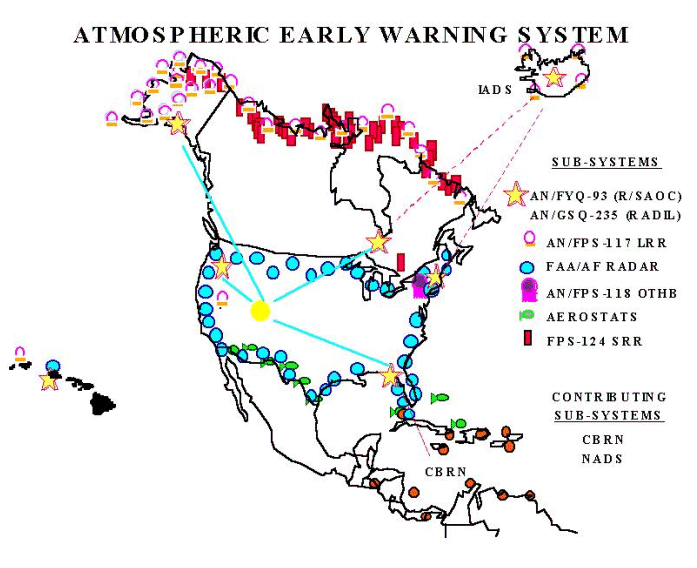
The backbone of strategic air defense sensor segment is the Joint Surveillance System (JSS). Within the JSS, the FAA/Air Force Radar Replacement (FARR) program replaces current radars with new air route surveillance radars (ARSR), specifically the ARSR-4. Other sensor systems tying into the strategic air defense network are the North Warning System (NWS) with AN/FPS-117 long range radars and AN/FPS-124 short range, unattended radars; the Iceland Air Defense System (IADS) with AN/FPS-117 long range radars; the Caribbean Basin Radar Network (CBRN) with AN/TPS-70 and AN/FPS-67 long range radars; the Over-the-Horizon Backscatter (OTH-B) and Relocatable Over-the-Horizon Radar (ROTHR) systems; and the Tethered Aerostat Radar System (TARS) with short range radars. Since 1992, reductions in the operations and maintenance tempo of the North Warning System radars along Alaska’s northern coast and across Canada’s Arctic have reduced costs by about 50%.

All of the sensor, fusion, control, and combat systems work together to provide CINCNORAD and his commanders with the capability to defend North American airspace from threat, regardless of alert levels. The sensor systems augment one another to some degree to provide varying levels of geographic, altitude, and range coverage. The Airborne Warning and Control System (AWACS) augments both the sensors and the Region/Sector Operations Control Centers (R/SOCC) in providing a highly flexible command and control platform for long range detection and engagement of airborne threats. Sensor data from all available sources is fed to command, fusion, or intelligence centers where it is processed and correlated with available flight planning data from several US and other government sources. Applicable data is then displayed to allow operational commanders to make decisions as to level of response required, if any, from monitoring to neutralizing or destroying the target. Ground based systems are usually fixed although some are technically mobile. AWACS is used based on need and availability. In addition to long range detection, it is used to provide higher confidence level identification and monitoring of ambiguous threats. It can also be used as a gap filler in case of problems with primary systems.
Sources and Resources
http://www.fas.org/nuke/guide/usa/airdef/radar.htm
Maintained by Webmaster
Updated Sunday, April 23, 2000 7:24:33 AM
