
Page
2–1. Cloud and Non-Cloud Features
008. Cloud features
009. Non-cloud features
010. Topographic influences
2–2. Upper-Level Flow and Features
011. Composition of the wind field
012. Upper tropospheric interpretation
013. Cloud pattern recognition
014. Upper-level wind flow determination
015. Synoptic feature identification and placement
016. Mesoscale convective complex (MCC) and severe thunderstorms
017. Tropical cyclone analysis
2–3. Low-level Flow and Features
018. Lower tropospheric interpretation
019. Cloud pattern recognition
020. Low-level wind flow determination
021. Synoptic feature identification and placement
2–4. Atmospheric Flow
022. Baroclinic lows
023. Life cycle of a baroclinic low (frontal wave stage)
024. Life cycle of a cut-off low
2–5. Local Circulation
025. Specific local circulations
026. Land/water interface
027. Air/water interface
N this unit wewill primarily use the visible and various infrared data in cloud identification. Wewill begin by looking at cloud and non-cloud features. We will then look at the different satellite signatures related to the atmospheric circulation by looking at the upper-level, the lower-level, atmospheric flow, and local circulation patterns and their cloud features. In the process, we useing the many data forms available, including the visible and the infrared.
Remember: In identifying clouds, we are NOT seeing what an observer sees from the ground! Hence, we learn the cloud signature terminology, as we see them from satellite.
In this section we will look at both cloud and non-cloud features and how to identify them.
When you interpreting cloud features, remember the considerations we previously discussed. These considerations need to be an integral part of the imagery interpretation concepts you’re going to read about next. Cloud features are important clues about the atmospheric stability and synoptic features.
Imagery interpretation concepts
When you interpreting specific features, first ensure you look at the whole satellite picture to decide what the feature is and how it fits into the synoptic situation. Don’t get tunnel vision and look at one specific feature. Use the different imagery together whenever possible to take advantage of each one’s unique properties. Look at water vapor (WV) imageryshould be looked at first. It allows you to determine the large-scale atmospheric patterns and flow. The visual (VIS) will defines small scale features, terrain, cloud shadows, texture, and low clouds. Infrared (IR) imagery allows you to find relative cloud heights and, from there,thus specific cloud types. Continuity is another excellent way to follow cloud features; always use it and should always be used. At night when no VIS is available, look at the last VIS and far infrared (FIR) of the day. Then follow the features on the FIR through the night, keeping in mind what they would look like on the VIS. Always use your atlas or local terrain map when you interpreting the imagery. This ensures you don’t mistake terrain features for clouds (for example, the difference between fog/stratus and snow).
Terminology
We use Ccertain terms are used extensively in METSAT imagery interpretation. They are valuable because they actually give you a label for certain atmospheric processes. For example, cloud lines typically indicate parallel wind flow.
Cloud type
This is a form of cloud seen in the sky (cumulus, altocumulus, etc.).
Cloud element
This is the smallest cloud that you can be seen on an image as determined by the resolution of the METSAT sensor.
Careful examination of the cloud lines forming over Wisconsin (fig. 2–1) will reveals individual cloud elements. These elements are small bright cells, separate from each other, which makeing up the cloud line over Wisconsin.
Figure 2–1. Cloud elements.
Cloud fingers
These are low-level clouds that develop because of low-level convergence.
Cloud lines
These are A nearly continuous cloud formations where elements ARE connected and the line is less than 1° in width. Cloud lines parallel the vector difference between the wind velocity at the base and top of the cloud. Cloud lines tend to parallel each other. Figure 2–2 shows several nearly parallel cloud lines in the Gulf of Mexico off the Texas and Louisiana coast.
Figure 2–2. Cloud lines.
Cloud streets
These are very similar to cloud lines, however, the elements are NOT connected. Cloud streets also parallel the vector difference between the wind velocity at the base and top of the cloud. These are common in the tropic and subtropic regions. Figure 2–3 shows cloud streets over South Carolina and Georgia as seen from Gemini IV. The cumulus elements form into nearly parallel rows.
Cloud types
Being able to identify different cloud types is useful for atmospheric stability. To do this, first you’ll need to determine the level where the cloud is. Then, determine the type of cloud.
Figure 2–3. Cloud streets.
Low clouds
Low clouds will show a variety of shapes and dimensions due to the effects of diurnal temperature changes, thermal advection, low-level convergence or divergence, terrain effects, land/water and air/sea interface.
Fog and stratus
Determining fog and stratus on METSAT imagery is difficult to begin with. It is further complicated because it willthese weather elements have a variety of gray shades on IR imagery during different seasons. However, with continuity and knowledge of the synoptic pattern, you can find it easily.
Stratus
These are low clouds caused by the advection of warm moist air over a cooler area (for example, lifting of fog during stable conditions, or evaporation of precipitation into cool air). This is a common phenomenon during the night and early to mid-morning hours.
Fog
This is a stratiform cloud with its base on the ground. It is, composed of water droplets (except ice fog). Radiation fog and sea fog are the two types we can discern best on imagery. On the imagery, radiation fog will dissipates from the outside edges into the middle due to differential heating. Advection fog (sea fog) is very similar to stratus in its characteristics.
Appearance
Fog and stratus (ST) are easier to see on VIS imagery because of the good contrast between the fog/stratus and the terrain. The two may be differentiated by noting the motion of the cloud mass. Fog typically remains stationary, while ST moves.
On visual imagery, fog and ST appear as a white to light gray shade in a uniform sheet with no texture. Any sharp boundaries are normally caused by higher terrain features that may penetrate the cloud top. Cloud edges will define terrain features and elevation changes (for example, in eastern Colorado and New Mexico where the plains rapidly lead into a mountainous region). In mountainous or hilly areas, fog and ST in small valleys may have a branching or vein-like appearance. Fog and ST are at their brightest over deep terrain. Fog/stratus may sometimes look like snow on mountain ridges. If the visibility at the surface is greater than the vertical depth of the fog and the, sky is discernible, the fog may not be visible on the image.
Fog and ST appear on FIR imagery as a dark gray shade (warm temperature) due to the small thermal contrast between the fog/stratus and the surface. Fog and stratus are very hard to detect. Occasionally, ST forming underneath a radiation inversion will appears as a darker gray shade and warmer than the surrounding surface area that will beis cloud free. This is known as black stratus. If available, use the Defense Meteorological Satellite Program (DMSP) nighttime VIS imagery to detect black stratus.
Stratocumulus
Stratocumulus (SC) is formed by the spreading out of cumulus or the lifting of stratus. This occurs with a stable layer aloft and limited vertical mixing in the lower level and is, usually a subsidence or frontal inversion. Areas of SC typically develop in stable regions dominated by high-pressure systems (for example, in association with high pressure behind a cold front moving off the East Coast). It can also form due to weak cold-air advection over a warm surface (for example, in polar air masses over land with strong surface heating).
SC appears on VIS imagery as a light gray to white shaded, continuous cloud sheet composed of parallel rolls or cellular elements with a textured appearance. In the tropics, SC is usually widely scattered except in upslope regions or where the clouds pack against terrain features.
On FIR imagery, SC clouds appear as a dark gray shade, suggesting warm temperatures. The cellular or textured appearance may not be observable due to the sensor resolution.
Cumulus
Cumulus (CU) are small, vertically developed clouds that form due to either surface heating, low-level convergence, or both. These clouds are very common over land during the warm season, and in the tropics. CU will dissipates over and downwind of lakes or coastlines. This is due to differences in land and water temperatures (for example, Great Lakes, Gulf Coast). As cumulus develops over land and moves over relatively cooler lakes, it will dissipates. Where the cooler lake temperature advects downstream, there’ll be a clear area for a distance before it begins to heat up again and form more CU.
Cumulus appears on VIS imagery as a small, white cloud which is usually seen as a field of unorganized "popcorn" CU. Many individual elements will beare below the sensor resolution of most satellites. Often a field of CU will appears as a uniform lighter gray shade because the sensor will averages the smaller cloud element’s gray shade with the background’s gray shade.
On FIR imagery, only the large concentrated areas of CU will show up. and tThey’ll appear as a very dark gray shade, which representsing warm temperatures. The field of CU will appears as a slightly lighter gray shade than the earth’s surface because the cloud elements are below the sensor’s resolution.
Towering cumulus
Due to a more unstable atmosphere, towering cumulus (TCU) is more vertically developed than CU, which makes themit easier to see on the imagery. TCUs may be embedded within or at the downstream edge of a field of CU.
Towering cumulus are circular clouds that appear light gray to bright white on VIS imagery. On FIR imagery, the light gray shade makes them easier to detect than CU. Due to the sensor’s resolution, the tops may be contaminated. Depending on the enhancement curve we used, the tops may be contoured. This , helpsing to define the cloud height.
Cumulonimbus
Cumulonimbus (CB) clouds are cumulus clouds of strong vertical development, with or without an anvil cirrus plume. CB clouds vary in size and shape, depending on the storm intensity and the storm environment in which they develop in. The size and shape of the anvil cirrus are determined by the strength of the upper-level winds. The cirrus will beis circular with light winds and elongated downstream with stronger winds. CB clouds can develop singularly, in clusters or in lines. In large clusters or lines, individual cells may not be identifiable due to the combined effects of the anvil cirrus making one large cirrus canopy and covering the cells.
CB clouds appear very bright white with a round or elongated anvil plume on VIS imagery. Because of the upper-level winds, a CB may have a sharp upstream cloud edge and thin, diffuse anvil cirrus downstream. We can detect Iindividual cells, known as "overshooting tops,"can be detected above the cirrus canopy when the sun angle is low, due to shadows we seen on the cirrus canopy. CB clouds will also cast shadows on lower cloud decks with a low sun angle. Often, decaying CB clouds leave behind a cirrus plume cloud and low- and mid-level clouds.
CB clouds appear bright white and usually cellular on FIR imagery. On enhanced IR imagery, step contouring will helps define the CB. Smaller CB clouds will beare difficult to discern if they are embedded in a cirrostratus shield. A light gray shade gradient is present on the upstream edge of the anvil cirrus where the CB is. The gray shade gradient loosens rapidly downstream.
On WV imagery, CB clouds appear a very bright white shade; however, individual cells are usually not identifiable.
Special low cloud types
The special low cloud types we’ll discuss are large cloud patterns associated with certain synoptic situations. Because of their unique formation characteristics, they are classified differently for our purpose.
Cumulus lines/streets
These clouds are mainly formed due to surface heating and strong vertical wind shear. Strong vertical wind shear results in the formation of the clouds into lines or streets. These long narrow lines of unconnected cumuli are not more than 60 nautical miles (nm) apart and are parallel to the low-level wind direction. CU lines/streets appear the same as CU on VIS and FIR imagery, except that they are in lines and streets.
Stratocumulus lines
These are SC elements formed by low-level instability that is caused by a large air/sea temperature difference (for example, continental polar air speedily advected offshore over warmer water). The lines are created by the strong vertical speed shear or strong low-level winds (³ 15 knots) and an inversion that caps the vertical development of the cloud. The elements form a line of connected stratocumulus clouds that is aligned with the wind direction normally with a well-defined clear area along the upstream shore.
Figure 2–4 shows SC lines in weak and strong vertical speed shears. Under similar conditions as closed-cell stratocumulus, clouds often merge into such a field.
On VIS imagery, SC lines appear light gray to white, depending on the contamination factor. There are sSmall cells on the upstream side that conform to the coastline and they get larger downstream. The individual cloud elements may not be identifiable as they often merge into SC fields downstream. The smaller elements mean more closely packed lines and the stronger the winds. The elements eventually enlarge as the winds decrease. The winds must decrease to less than 20 knots to see a visible separation of cloud elements.
Figure 2–4. Stratocumulus lines.
FIR imagery shows SC lines as a medium to dark gray shade, which indicatesing warm temperatures. Thermally warm and uniform, difficult to distinguish due to contamination or vertical temp profile when lines are small, . Tthe lines may or may not be identifiable, depending on the sensor resolution. You can see Sstratocumulus linesmay be seen on the CC, EC, or JG curves.
Closed-cell stratocumulus
Closed-cell SC is cellular, closely packed SC that forms mostly over ocean areas. They have rising air in the center of closely packed cloud cells with descending air at the edges. The individual elements vary in size from 5 to 50km. They’re typically found in large sheets and are associated with the anticyclonic flow of the subtropical high or with high-pressure systems behind cold fronts. Wind speeds are generally less than 20 knots and the wind direction is perpendicular to the strands. Clouds typically are located in the southern half of the high.
Closed-cell SC is formed due to low-level instability or to convective mixing with a strong subsidence inversion capping the mixing. The instability or mixing is due to either surface heating, radiative cloud top cooling, or weak cold-air advection over a warmer water surface.
Closed-cell SC appears on VIS imagery as gray shades that rangeing from white in the center to medium gray to white on the edges. They will have a large quilt-like pattern with a slight separation between elements.
On FIR imagery, closed-cell SC will usually appears similar to ST; that is, it is, thermally warm, with a very uniform, medium to dark gray shade due to resolution problems.
Open-cell cumulus
These are CU clouds that usually form over water behind mid-latitude cyclones and are caused by strong cold-air advection over warmer water. They are associated with cyclonic or straight-line flow. There is a sharp transition between cellular clouds, which showsing a separation between stable (closed-cell SC) and unstable (open-cell CU) air. Their vertical development is typically capped by a weak inversion above the cloud layer. The elements vary in size from 5 to 50km.
Open-cell CU appears on VIS imagery as open and closed ringlets of CU with clear centers like chicken wire on VIS imagery. In strong low-level winds, these ringlets will become distorted and line up. Individual elements may be difficult to detect due to the sensor’s resolution.
On FIR imagery, open-cell CU appears medium to dark gray due to contamination and resolution problems. Parts of the open-cell CU field may appear as a uniformly darker grayshade than the rest of the field. Although open-cell CU is higher than closed-cell SC, open-cell CU will looks lower due to contamination and sensor resolution.
Figure 2–5. Typical cellular cloud patterns.
Closed-cell SC has larger cloud elements with very little of the surface showing through to the METSAT sensor. This allows for a more accurate cloud-top temperature measurement. With open-cell CU, more of the surface is showing through to the METSAT sensor. The clouds are smaller and narrower than closed-cell SC. The sensor averages the open-cell CU and the surface of the earth, which results in a higher temperature than the actual cloud-top temperature. Figure 2–5 illustrates the typical open-cell and closed-cell patterns. Figure 2–6 shows both open-cell and closed-cell patterns in the Pacific Ocean.
Figure 2–6. Open-cell and closed-cell clouds.
Enhanced cumulus
Enhanced CU is an area of TCUs and small CB clouds found found in an area of open-cell CU due to a secondary vorticity maxima or positive vorticity advection. Winds are generally 10 to 20 knots higher than those in the surrounding area. Enhanced CU looks the same as small CB clouds or TCUs on VIS imagery. The convective cluster may even have a comma-shaped appearance. Visually they are bright white "blobs." On FIR imagery, enhanced CU appears to be in the same gray shade as with CB clouds/TCUs in gray shade. On enhanced IR imagery, the clouds will be are contoured, which will helps define higher cloud tops. The tops are cold due to vertical development;, therefore, we refer to them as "enhanced." In WV imagery, enhanced CU is bright white with the same cloud shape as the VIS and FIR.
Actiniform clouds
These are the skeletal remains of closed-cell SC, which isare easily confused with open-cell CU. Actiniform clouds are found in or along the western side of the closed-cell SC.
On VIS imagery, actiniform clouds are light gray, due to contamination, with a fish bone or chicken wire appearance.
Actiniform clouds are medium gray to dark gray, showing up slightly warmer than open-cell CU on FIR imagery. Individual elements are not identifiable. If too much contamination is present, the area will shows up as a dark spot or hole in the clouds.
Arc clouds
This is a curved line of CU clouds is formed due to a thunderstorm downdraft of cold dry air. It’ll looks the same as CU/TCU/CB clouds on the VIS and FIR imagery.
Rope clouds
This is a very narrow line of CU/TCU usually found over water and occasionally over very moist coastal land areas. Rope clouds can range from several hundred miles in length to several thousand. They are very representative of the surface cold front over water. The rope cloud has the same appearance as CU/TCU in the VIS and FIR imagery.
Middle clouds
Middle clouds are composed of supercooled water droplets and ice crystals. Often these clouds are hidden by higher level clouds or, if fragmented, mistaken for other cloud types.
Altostratus/Nimbostratus
These y’reare extensive sheets of stratiform clouds found in the mid levels. Altostratus (AS) and nimbostratus (NS) are found in the eastern portion of surface cyclones and the leading edge of frontal systems. These clouds are often masked by higher level clouds in active regions of comma-cloud systems.
AS and NS appear on VIS imagery as a bright white, extensive sheet, which is fairly uniform. Shadows either cast on, or by, AS/NS can help you distinguish them from cirrostratus and ST.
On FIR imagery, they appear as a uniform gray shade that rangesing from medium gray to light gray. AS/NS will beis a lighter gray shade than low clouds and a darker gray shade than higher clouds. On enhanced IR imagery, you may see a gray shade contouring, depending on the enhancement curve used. The EC enhancement curve can help you to identify the mid-level clouds.
On WV imagery, the range of gray shades will variesy quite a bit depending on the amount of moisture above the AS and how thick the cloud layer is.
Altocumulus
Altocumulus (AC) suggests vertical motions and moisture at the middle levels of the troposphere. They’re hard to distinguish from AS because the individual convective elements may not be resolved.
Terrain-induced wave clouds, altocumulus standing lenticular (ACSL), are the most common type of AC cloud detected on METSAT imagery. They’re also known as mountain-wave clouds (see fig. 2–7). They’re regularly spaced cloud bands in a, herringbone pattern as it were,. They are formed when strong mid-level flow crosses a hilly or mountainous ridge line at a perpendicular or nearly perpendicular angle. The clouds form and dissipate due to the vertical up and down motions. They alternately condenseing and evaporateing moisture on the leeside of the mountains. Winds do not advect clouds;, the cloud bands remain along thewith mountain. Generally the wavelengths are proportional to the wind speed. The mountain-wave clouds in figure 2–76 are located over the northwest portion of Mexico.
Figure 2-7. Mountain-wave structure.
AC appears on VIS imagery as a bright white cloud sheet with a textured or lumpy appearance. Cloud bands or ACSL will parallel mountain ranges.
The appearance of AC on FIR/enhanced IR of AC is the same gray shades and enhancement capabilities as AS/NS, except the wave clouds frequently appear warmer (lower) due to contamination. This is especially true with higher elevation terrain located below the clouds.
On WV imagery, AC clouds will have the same imagery interpretation considerations as AS/NS.
High clouds
High clouds are composed of ice crystals. You’ll learn about the different types of cirrus and cirrostratus clouds and how to interpret for them. One high cloud type we’ll do not discuss is cirrocumulus. Since the elements are so small and below the sensor resolution, it this type is not typically identifiable on METSAT imagery.
Cirrus
Thin cirrus (CI) isappears as fibrous, wispy strands and filaments on VIS imagery. Thin CI is translucent, often obscuring the definitions of lower features, and will appears less brilliant than lower or thicker clouds. CI is difficult to detect due to visual contamination. Dense CI often looks like patches, streaks, or bands, and casts shadows on lower clouds or terrain. Fibrous bands are often perpendicular to the winds while streaks are parallel.
On FIR, imagery dense patches of CI are bright and thin CI is very contaminated and appears warmer than the actual temperature. The gray shades will have a large range due to the problems with contamination. Enhanced IR imagery will shows gray shade contouring on most enhancements, even with thin CI.
On WV imagery, CI ranges from a light gray to a bright white shade, depending on how thick the cloud is and the amount of water vapor below it.
Special types of cirrus
These cloud patterns give you clues as to how the atmosphere is behaving. This can be useful for updating upper-air products, filling data void regions, or for determining hazards for pilots and missions.
Cirrus streaks
These are small isolated patches of CI generally occurring away from other clouds and aligned with the upper-level winds. They develop in areas where there is insufficient moisture for an entire CI shield to form. Cirrus forms on the backside of the trough along a channel jet
Thin wisps of CI are very susceptible to contamination. On VIS imagery, the gray shades will range from medium gray to white.
CI streaks appear on FIR imagery as a medium gray to white shade. Again, the imagery is very susceptible to contamination. On enhanced IR imagery, gray shade contouring is limited due to contamination problems.
CI streaks appear on WV imagery as a light gray to white shade, depending on the amount of moisture in the atmosphere.
Transverse bands
Transverse bands are irregularly spaced, parallel bands of thin CI filaments and strands oriented perpendicular to the wind flow. The speeds in transverse bands are usually greater than or equal to 80 knots. Cirrostratus will typically obscures transverse bands in the middle latitudes, making it difficult to detect them. Transverse bands appear similar to CI streaks on VIS, FIR, and WV imagery. Light to moderate turbulence is commonly associated with this cloud type.
Billow clouds
These clouds are regularly spaced parallel CI cloud bands that advect with the wind. They’re caused by vertical shear, due to the stronger winds aloft, although they can occur at low levels in the atmosphere. Billow clouds are oriented perpendicular to the winds. The distance between the billow cloud elements is less than with mountain-wave clouds. Varying degrees of turbulence is are associated with billow clouds. Winds advect the cloud bands. The wavelengths are proportional to the wind speed. Remember, billow clouds are not associated with terrain features;, they are caused by vertical shear aloft.
Billow clouds appear on VIS imagery as light gray to white with a washboard appearance. The clouds willare usuallybe thick versus filaments or strands. Contamination is a problem, depending on the spacing between elements.
Due to contamination on FIR imagery, the gray shades will range from medium gray to white. The individual elements may not be identifiable.
Billow clouds may appear disorganized and chaotic on EIR imagery. The appearance will varies,y depending on the cloud element spacing, cloud organization, and satellite resolution.
Billow clouds may or may not be detectable on WV imagery, depending. It will depend on whether there are other clouds over the billow clouds and how much moisture is available along with the other factors listed above.
Contrails
Contrails, (condensation trails), are CI cloud lines formed from jet exhaust that appear as unnatural anomalous cloud lines. They don’t last as long as ship trails because the upper-level winds are stronger and more mixing is occurring. You may see Tthesemay be seen on the FIRjust as a small thin CI cloud. Another factor will beis the sensor resolution versus the size of the cloud element.
Cirrostratus
These clouds are high, continuous, variably dense veils that , covering an extensive area. They appear on VIS imagery as a bright white gray shade. Cirrostratus (CS) is thick and fairly uniform except along the edges where it will beis thin and wispy. Because of its thickness, it’s not as subject to contamination. CS will casts shadows on lower clouds and surfaces.
On FIR and WV imagery, CS clouds appear as a uniform white shade, except at the edges where contamination is a problem. Enhanced IR imagery will contours the cloud tops, allowing you to define cloud heights. Except for CB clouds, these are normally the coldest cloud tops.
Anvil cirrus
Anvil cirrus or thunderstorm blowoff has a sharp upwind edge with a strong thermal gradient. The fuzzy, diffuse downstream edge is more translucent and appears warmer, but not actually lower. The blowoff from numerous thunderstorms combines to form an extensive CS canopy, which is aligned with the upper-level winds.
Anvil cirrus appears on VIS imagery as bright white on the upstream edge. They gradually darkening on the downstream side as itthey thins and becomes translucent. Unless overshooting tops are present, anvil cirrus is very smooth.
On FIR and WV imagery, theyanvil cirrus appears as bright white patches. On enhanced IR imagery, there is a contouring of the cloud tops to helping you define the height.
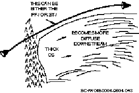
Lee-of-the-mountain cirrus
Lee-of-the-mountain cirrus or leeside cirrus is a multilayered CI cloud shield on the lee of a mountain chain. A sharp, stationary, upwind cloud edge, along the ridge line, shows the presence of standing mountain waves. Towards the downstream edge, they are more translucent and appear warmer, but not actually lower. They tend to form late at night and dissipate in the afternoon. There is an inversion or isothermal layer above the mountain tops. The cloud tops range from 25,000–35,000 ft with bases from 10,000–15,000 ft. Their occurrence appears highly dependent on the presence of a high-level moisture source in a strong wind zone. It’s typically located with, and just south of, the polar front jet (PFJ), but does not have to be near the jet stream. WV imagery helps identify areas of moist air where leeside cirrus may occur while other imagery will shows the area as cloud free. Leeside cirrus will affects temperatures by blocking out incoming solar radiation. Mountains as low as 1,000 feet can cause leeside cirrus.
On VIS imagery, Lleeside cirrus appears bright white with a sharp edge along the ridge line on VIS imagery. It can appear as thick as CS, but becomesing more diffuse downstream. Contamination is a problem on the downstream edge.
On FIR and WV imagery, lee-of-the-mountain cirrus is a bright white gray shade. Lee-of-the-mountain cirrus are the coldest non-thunderstorm clouds in the mid-latitudes. Enhanced IR imagery will shows contouring of the cloud tops.
Snow, ice, and lithometeors are the types of non-cloud phenomena we’ll discuss. We can easily mistake Ssome of these featurescan easily be mistaken for clouds if we do not use viewing considerations and continuity are not used. In recent history, some of these phenomena have played a major role in favorable mission accomplishments.
Snow
VIS imagery picks up snow and ice much better than IR because of the brightness contrast on the imagery. (Reflectivity: New snow—88 percent; three- to seven-day-old snow—59 percent.) Following are some considerations when you interpreting for snow.
The brightness increases with a snow depth up to four inches. Above four inches, the brightness doesn’t change. Snow will havehas a dendritic (vein-like) pattern in mountain areas; rivers and lakes are sometimes snow free; and snowfields in the plain’s region tend to be long, narrow, and smooth with sharp edges.
Snow will havehas a mottled (blotchy) appearance in forested areas. It will beis bright white in the plains and decreasesing in brightness with increasing vegetation density and height.
The sun angle is an important factor because brightness decreases rapidly when the sun angle is below 45° . It is easier to discern snow from cloud cover with a low sun angle because of the shadows from the clouds. On FIR imagery, the detection of snow, ice, low clouds, and the ground is difficult without a simultaneous visual imagery. You may be able to see certain prominent terrain features.
Ice
Ice is seen on METSAT imagery in large lakes, bays, and seas (for example, the Great Lakes, Hudson Bay, Bering Sea). Ice will forms along the shorelines first. Offshore winds will move and break up the ice next to the shore. Water and new, thin, transparent ice will appears as a dark band along the shore.
Ice has the same gray shades as snow and is difficult to distinguish from snow cover on VIS and FIR imagery. There may be dark fractures or cracks in the ice that we called leads.
Lithometeors
Remember that lithometeors are dry, solid particles either suspended in the air or lifted from the ground by the wind. Therefore, lithometeors can and do show up on METSAT imagery.
Dust and sand
These are suspended surface particles are carried aloft by strong synoptic-scale surface winds for long distances. The upstream edge usually is not well defined. These appear most often in desert regions and in very dry, crop land areas (e.g., Arizona, Texas, Kansas, Sahara and Gobi deserts).
Dust has a filmy, diffuse appearance with a medium to light gray shade on VIS and FIR imagery. If it shows up on FIR, it will beis a dark to medium gray shade.
Smoke and ash
The sources for smoke and ash are fires, industrial areas, and volcanoes. Thesey phenomena usually have a sharp boundary at the source of the plume. Smoke and ash from volcanoes are discernible depending on the level of volcanic activity. Volcanic ash reaches ambient air temperature very rapidly. If a volcanic plume reaches high altitudes, the ash cloud will appears cold on the FIR and enhanced IR imagery. Ash clouds in the upper levels can be advected long distances by the upper-level flow. The upstream edge can be thick; while downstream, the ash cloud will becomes diffuse and thin. It will appears the same as thick CI on the VIS, FIR, and enhanced IR imagery.
Haze, pollution, and aerosols
On METSAT imagery, Tthesey’ll items appear on METSAT imagery in stable conditions with light winds. Haze is very common during the warm season in the subtropics (for example, southern and southeast US and California). Haze forms from suspended particles that absorbing water vapor in a high moisture atmosphere. Pollution consists of the by-products of industry, agriculture, and the burning of fossil fuels. Aerosols are small, suspended liquid or solid particles that absorb and scatter light.
On VIS imagery, Hhaze, pollution, and aerosols appearon VIS imagery to be dull, filmy, and diffuse with a light to medium gray shade, depending on the density. They are easier to see over dark terrain and become more diffuse due to atmospheric mixing.
On FIR imagery haze, pollution and aerosols appear only if they are at high altitudes or in large concentrations. Contamination is a major consideration with these features.
Your awareness of different topographic influences allows you to interpret all the features on the imagery correctly. We’ll discuss land, water, and solar effects on the METSAT imagery.
Variations in the earth’s surface
Over land you’ll get varying gray shades on VIS and FIR imagery, depending on vegetation coverage, rough versus smooth terrain, wet versus dry, and soil type. Over water you’ll see varying differences in gray shades due to wind speed, wave action, plant life, "muddy" water versus "clean" water, and the water depth, along with the topographical makeup of the ocean bottom.
Solar effects on imagery
Solar effects will provide valuable information on a variety of synoptic features. It isSuch effects are also useful for determining general wind flow patterns.
Sun glint
A Sun glint is caused by the reflection of the sun’s rays off the water surface directly into the METSAT sensor (seen only on visual imagery). A Sun glint typically occurs under stable conditions, with light or calm winds, such as with high-pressure systems, especially the subtropical ridge. Figure 2–8 is an example of a diffuse sun glint. Figure 2–9 shows an intense sun glint. Figure 2–10 shows a sun glint on the water surrounding Florida, which outlinesing the coastline in great detail. Tampa Bay is seen at A, and Cape Kennedy at B. The very bright spots at C are from a sun glint on the many lakes of central Florida, while a sun glint on Lake Okeechobee is seen at D.
Figure 2–9. Intense sun glint.
Geostationary imagery
The sun glint pattern will havehas a circular shape to it when we viewed it with a geostationary METSAT image. The higher the wind speeds, the larger and more diffuse the sun glint pattern will be. The lower the wind speeds, the smaller, brighter, and more well defined the sun glint pattern will be.
Polar orbiting imagery
These show a line pattern from the top to the bottom of the picture if the satellite subpoint and the solar subpoint are sufficiently close. The sun glint is produced by the reflection of sunlight off many small waves when the satellite is at a latitude other than the solar subpoint. The higher the wind speed, the larger and more diffuse the glint zone will be. The lower the wind speeds, the smaller and more intense the sun glint will be.
Land sun glint
A land sun glint occurs over very wet, flat terrain, such as that found over China’s rice patties, flooded lowlands, rivers, and lakes.
Sun glint utility
We use Ssun glint is used to estimate the surface wind speeds, direction (occurs in areas of anticyclonic flow), and sea state. We also use Ssun glint is also used to locate flooded lowlands that can be used for the Army trafficability support (to . Army trafficability support isdetermine whether Army vehicles can travel over a specific surface).
The terminator
This phenomenon is only seen on visual imagery. It’s the transition line from day to night. It deceives by "hiding" major systems behind the line, thus making the systems seem less ominous. It’s very distinctive on geostationary imagery.
Self-Test Questions
After you complete these questions, you may check your answers at the end of the unit.
008. Cloud features
1. Match each cloud formation/appearance in column B with its description in column A. Cloud formations are used only once.
Column A _____1. Common in the tropic and subtropic regions. _____2. A cloud form such as stratus, altostratus, etc. _____3. Low-level clouds that develop because of low-level convergence. _____4. The smallest cloud seen on an image as determined by the resolution of the satellite sensor. _____5. A nearly continuous cloud formation where elements are connected and the line is less than 1° in width.Column B a. Cloud type. b. Cloud lines. c. Cloud element. d. Cloud streets. e. Cloud fingers. |
Column A _____1. These clouds look the same as a small CB cloud or TCUs on VIS imagery. _____2. These appear on VIS imagery as light gray to white with a washboard appearance. _____3. These appear bright white with a sharp edge along the ridgeline on VIS imagery. _____4. These are medium gray to dark gray showing up slightly warmer than open-cell CU on FIR imagery. _____5. On VIS imagery, these clouds appear light gray to white depending on the contamination factor. _____6. On visual imagery, these appear as a white to light gray shade in a uniform sheet with no texture. _____7. On VIS imagery, Tthese clouds appear on VIS imagery as a bright white cloud sheet with a textured or lumpy appearance. _____8. On VIS imagery, Tthese clouds appear on VIS imagery as gray shades, ranging from white in the center to medium gray to white on the edges. _____9. On WV imagery, these range from a light gray to a bright white shade, depending on how thick the cloud is and the amount of water vapor below them. ____10. On FIR imagery, only the large concentrated areas of these clouds will show up; and they’ll appear as a very dark gray shade, which representsing warm temperatures. ____11. On FIR imagery, these clouds appear as a dark gray shade, which suggestsing warm temperatures. and tTheir cellular or textured appearance may not be observable due to the sensor resolution. |
Column B a. Cirrus. b. Cumulus. c. Altocumulus. d. Billow clouds. e. Stratocumulus. f. Fog and stratus. g. Enhanced cumulus. h. Actiniform clouds. i. Stratocumulus lines. j. Closed-cell stratocumulus. k. Lee-of-the-mountain cirrus. |
009. Non-cloud features
1. Why does VIS imagery pick up snow and ice better than IR imagery?
2. Why is sun angle an important consideration when we looking at snow?
3. How does dust appear on METSAT imagery?
4. How do haze, pollution, and aerosols appear on VIS imagery?
5. How do haze, pollution and aerosols appear on FIR imagery?
010. Topographic influences
1. What causes sun glint?
2. How does sun glint appear on geostationary satellites? Polar orbiting satellites?
3. What is sun glint used for?
4. What METSAT imagery does the terminator phenomena appear on?
In this section you’ll learn the fundamentals inof interpreting upper-level flow and synoptic-scale features on METSAT imagery. Using METSAT imagery with the various products allows you a more objective look at the atmosphere. In this section, we’ll consider only the METSAT imagery and how to analyze the features and flow can be analyzed on the METSAT imagery. Understanding how to determine the wind flow and upper-level features on METSAT imagery allows you to continue to forecast weather even if you do not receive any products during certain periods or situations. METSAT imagery also fills in data sparse areas and between synoptic stations.
011. Composition of the wind field
Before we can look at interpreting the upper troposphere on METSAT imagery, we need to define the composition of the wind field in the atmosphere (see fig. 1–356).
Translation
Translation is the movement of an air parcel in a straight line. Theoretically, all air parcels will move at the same speed in the same direction. We commonly use Ttranslation is commonly used to measure the speed of lows, the jet maximum, etc.
Rotation
Rotation is a circular wind pattern turning around a specific point. Cyclonic rotation is positive rotation and anticyclonic rotation is negative rotation.
Divergence (convergence)
This is a spreading (contraction) of the wind field away from (divergence) or toward (convergence) a central point.
Deformation
Deformation is the stretching or shearing of the wind field. The wind flow in a field of pure deformationwould shows a specific streamline pattern. There are three parts to a deformation zone we need to identify.
Col (neutral point)
A col is the center of the deformation zone where the winds are calm.
Axis of dilatation
The horizontal axis where air parcels are moving away from the col is called the axis of dilatation.
Axis of contraction
The axis of contraction is the horizontal axis where air parcels are moving toward the col.
Although we defined four types of motion separately, normally a combination of these motions occurs; and they may look quite different from the pure form.
For example, surface winds around a low-pressure area primarily are composed of primarily rotation and convergence (see fig. 2–11). Deformation combined with translation will appears as difluence in the wind flow (fig. 2–12).
Figure 2–11. Flow with the low.
Figure 2–12. Deformation.
When we viewing cloud systems on METSAT imagery, we need to consider the four basic types of motion as well as, also the combinations of it.
012. Upper tropospheric interpretation
Meteorologists rely on constant-pressure products to view the atmosphere. This is how they identify low height centers, fronts, etc. In METSAT imagery interpretation, we have a different way of looking at weather features. METSAT imagery allows us to see the cloudiness a feature produces.
WhenIn interpreting METSAT imagery, we’ll first identify cloud patterns. This is called cloud pattern recognition. Second, we’ll use cloud pattern recognition, and cloud and non-cloud phenomena, to help us determine wind flow. Third, we’ll use the cloud patterns and wind flow to determine specific synoptic features and relate them to the map features.
You must view Tthe cloud patterns must be viewed a couple ofseveral different ways when you interpreting METSAT imagery. First, you may not see the moisture on the different upper-air products. The detectable moisture can begin and/or end at levels in the atmosphere between the upper-air levels analyzed. Second, use the cloud patterns to draw in moisture patterns when you analyzeingyour upper-air products. The METSAT imagery may be showing areas of moisture that falls between upper-air stations on the product.
013. Cloud pattern recognition
With experience, you’ll begin to recognize cloud patterns quickly and understand their meteorological significance. Over the next lessons you’ll learn about basic cloud patterns and their meaning to you.
Baroclinic leaf
This is a thick mid- and upper-level cloud pattern is recognized as the first sign of comma-cloud development. It normally has a shallow "S" shape on the sharp, upstream edge of the cloud system. A unique characteristic is the "V" notch in the tail of the leaf. This cloud feature is seen in straight-line to cyclonic flow. Baroclinic leaves will beare smaller than the more developed synoptic systems, such as baroclinic zone cirrus. Baroclinic leaves will vary in shape, as seen in figure 2–13. Figures 2–14 to 2–16 show the evolution of a baroclinic leaf in the central US.
Figure 2–13. Baroclinic leaves.
Figure 2–14. Baroclinic leaf, 25 Sep 85, 0001Z.
Figure 2–15. Baroclinic leaf, 25 Sep 85, 1201Z.
Figure 2–16. Baroclinic leaf, 25 Sep 85, 1501Z.
Comma cloud structure
Comma clouds are associated with low-pressure systems within the mid-latitude westerlies. There are three cloud features that make up a synoptic-scale comma cloud. Figure 2–17 shows the makeup of a comma cloud.
Figure 2–17. Comma-cloud structure.
Baroclinic zone cloud system
Multilayered clouds are associated with the cold and warm fronts. Multilayered clouds are usually topped by a large CS shield and precipitation is continuous with possible thunderstorms embedded. The PFJ is located on the poleward side of the baroclinic zone clouds. The baroclinic zone cloud system is associated with the thickness ribbon on the thickness product.
Clouds are due to deformation of the thermal gradient, and, therefore, vertical motions. These Ccloud systems are layered with mostly cirrus tops.
Vorticity comma-cloud system
This is low to mid-level cloudiness in a comma shape is, associated with a vorticity maximum. The vorticity comma cloud is often hidden around the higher baroclinic and deformation cirrus cloud cover. Precipitation is convective in nature within this cloud pattern.
Rotation resultsing in convergence and, then, strong vertical motions. When a vorticity cloud system is not overshadowed by baroclinic zone cirrus, it is overshadowed by convective clouds.
Deformation zone cloud system
Cirrus clouds west to north of an upper-level low will range from very thin to very thick. The cirrus clouds are usually lower than the baroclinic zone cirrus. The baroclinic and deformation zone cirrus may or may not merge. An upper-level deformation zone is associated with this cloud system.
Clouds warmer than baroclinic zone cirrus stretch along the axis of dilatation. A Ddark region in water vapor runs along the axis of dilatation and is , easily mistaken for jet location. Figures 2–18 and 2–19 show a deformation zone cloud system in the central US on the MB curve and a visual imagery an hour-and-a-half later.
Figure 2–18. Deformation zone cloud system on MB imagery.
Figure 2–19. Deformation zone cloud system on visual imagery.
Surge region (dry slot)
The surge region (fig. 2–20) is the dry intrusion of air into the comma. It’s located near the region of highest winds, near the cloud-top level (excluding convective activity). The surge region is commonly called the dry slot.
Figure 2–20. Surge region.
The northern portion of the comma cloud is known as the comma head. The comma tail typically extends from the comma head to the south or southwest (see figs. 2–21, 2–22 and 2–23).
Figure 2–21. Comma head/tail.
Figure 2–22. Comma cloud on visual imagery.
Figure 2–23. Comma cloud on IR imagery.
The flow in the western portion of the comma cloud is cyclonic. The flow behind the comma cloud is also cyclonic. Anticyclonic flow is located in the extreme eastern portion and ahead of the comma cloud. Figure 2–24 illustrates the upper-level circulation associated with a comma cloud.
Ridge pattern
This ridge pattern is indicated on imagery as an anticyclonically curved multilayered cloud pattern (baroclinic zone cirrus). Clouds will show ridge amplitudes ranging from sharp to broad, and are prevalent on the upstream side of the ridge axis. It Such a pattern usually has a well-defined cloud edge on the poleward side where the jet stream is typically located (see fig. 2–25).
Figure 2–25. Ridge pattern.
Trough pattern
The trough is located slightly upstream from the comma-shape cloudiness theyit produces and/or influences (fig. 2–26). The comma-shape clouds may be in the form of enhanced CU, baroclinic leaves, an "S" shape or bulge in frontal cloud bands, and comma-cloud systems. Cyclonic flow is associated with troughs. Figures 2–27 and 2–28 show a trough and ridge pattern on visual and IR imagery.
Figure 2–27. Trough and ridge pattern on visible METSAT imagery.
Figure 2–28. Trough and ridge pattern on IR METSAT imagery.
Low center
These are identified by the cyclonic swirl in the clouds. The amount and type of associated cloudiness will depends on the intensity of the system and moisture availability. Figure 2–29 shows two examples of low centers.
Figure 2–29. Low centers.
014. Upper-level wind flow determination
Upper-level wind flow can be determined with two different techniques. One is by following specific cloud elements on animated METSAT imagery to determine the flow. This technique is used at research centers, weather centrals, and stations with looping capabilities. The second technique is to interpret specific cloud and non-cloud phenomena to determine wind flow.
Empirically, wind observations have been noted with certain cloud and non-cloud phenomena. The technique we’ll discuss is interpreting specific cloud and non-cloud phenomena. We’ll use different types of METSAT imagery to determine wind flow and synoptic features.
When we viewing certain cloud and non-cloud phenomena on VIS imagery, the upstream cloud edge will beis very sharp and well defined. The cloud will becomes very thin and diffuse with the flow downstream. The wind flow is coming from the sharp upstream edge. If the weather system producing the clouds is stationary or nearly stationary (for example, cut-off lows), the cloud pattern will provides a fairly accurate idea of the upper-level wind flow. The clouds will beare aligned parallel to the upper-level wind flow.
When the parent weather system is moving, the upper-level clouds can still be a fair approximation of the upper-level wind flow. This is a fair assumption because the wind at the upper-level usually blows much faster than the system moves. A good example is anvil cirrus. A CB is moving toward 100° at 25 knots (see fig. 2–30).The 300-mb winds are toward 60° at 30 knots. The resultant is 20° at 20 knots. This is the direction toward which the anvil cirrus is moving toward.
On enhanced IR imagery, the tightest gray shade gradient is on the upstream side. The gradient spreads out downstream as the cloud thins and shows increased warming (contamination). This is normally true for synoptic-scale systems but not always for mesoscale features like thunderstorm complexes.
On FIR and WV imagery, the lightest gray shades are usually on the upstream side and they gradually become darker as you go downstream.
Other cloud types we used to empirically determine wind direction are discussed below.
Cirrostratus/baroclinic zone cirrus
Cirrostratus will forms on the equatorward side of the jet stream. Because of translation and divergence, winds are not always oriented in the same direction as the PFJ axis. Winds near the PFJ axis are parallel, or nearly parallel, to it. Further to the equatorward side of the PFJ, winds will beare at a slight angle to the right (see figure 2–31).
Cirrus streaks
Cirrus streaks usually form parallel to, and on the equatorward side of, the jet stream flow and need at least 60 knots for formation. These are normally observed in the base of the trough and between the trough and the upstream ridge axis.
Contamination is a problem with VIS, FIR, and enhanced IR imagery. On WV imagery, there usually is a contrast between moist (light), on the equatorward side of the jet, and dry (dark), on the poleward side.
Lee-of-the-mountain cirrus
These clouds form on the leeside of the mountain and on the equatorward side of the jet stream axis. The jet stream may or may not be close to the cirrus clouds. The winds are parallel to the cloud strands with the upstream cloud edge typically conforming to the mountain ridge line (fig. 2–32).
Transverse bands/billow clouds/mountain-wave clouds
Remember these clouds have a washboard or banded appearance with the wind flow perpendicular or nearly perpendicular to the clouds. We’ll assume the winds are perpendicular to the clouds. To determine the level of the winds, determine the cloud-top temperature and then compare it to an appropriate sounding. You can also use observations from the area.
015. Synoptic feature identification and placement
The ability to identify systems on METSAT imagery depends on the type of weather and the amount of cloudiness associated with the system. Lows and troughs that produce significant cloudiness and weather are the easiest to identify. If a system does not produce a large cloud signature, METSAT imagery can still be a useful tool in identifying the feature. A careful analysis of the surrounding area may reveal conditions that do or do not support the feature in question, although it is not possible to "see" the feature itself on the METSAT imagery. An example of this is determining upper-level high centers located in the long-wave ridge.
Techniques for locating the jet stream
These techniques will help you determine the jet stream axis and the speed maximum through empirically observed cloud features associated with the jet stream. The first three rules we’ll discuss are empirically observed cloud features that have worked well in locating the jet stream on METSAT imagery.
Baroclinic zone cirrus (cirrus shields)
The jet will causes a sharp poleward edge on the large cirrus shield (figure 2–33). The jet axis position is about 1° latitude on the poleward side of the cloud edge. While the baroclinic zone cirrus is usually smooth in appearance, the middle clouds on the poleward side of the jet stream will have a textured or lumpy appearance.
High or middle clouds in absence of the cirrus shield
Where baroclinic zone cirrus is not present, but other high- or mid-level clouds are, the cloud bands will beare most advanced downstream from the jet axis and the cloud band intersection (see fig. 2–34). Upstream cloud borders are usually well defined and form a U or V shape with the axis of maximum winds in or over the dry slot in the clouds.
Low cloud boundaries
When no high clouds (tops at jet stream level) are present, the axis of the jet stream is normally 1° to 3° on the poleward side of the boundary between the open-cell CU and the closed-cell SC (fig. 2–35). This boundary is most commonly observed over oceans where abundant low-level moisture is present. Over land, we find SC will be on the equatorward side. Clear skies are prevalent beneath and on the poleward side of the PFJ. This cloud pattern typically defines the jet stream in the long-wave trough positions. Figure 2–36 illustrates a composite of the three rules listed above.
Figure 2–36. Composite of the jet stream location rules.
Other cloud phenomena
These phenomena can also help you locate the jet stream.
Cirrus streaks
Cirrus streaks form parallel to the flow, on the equatorward side of the jet axis, and at the leading edge of a jet maximum.
Transverse bands
The jet axis flows perpendicular to the cloud band orientation and is located on the poleward side of the cloud bands. When associated with the PFJ, it typically indicates the speed maximum. It also indicates the subtropical jet (STJ) axis and is most commonly seen with this jet.
Billow clouds
These are cloud bands are oriented perpendicular to the jet stream flow and located on the equatorward side of the jet stream axis.
Lee-of-the-mountain cirrus
If the jet stream axis is located with this cloud feature, it’s about 1° of latitude on the poleward side of the cirrus cloud.
Cloud shadows
Baroclinic zone cirrus casts cloud shadows onto low- and mid-level clouds. The jet axis is typically 1° latitude poleward of the cirrus cloud deck that is casting the shadow.
Areas where the jet stream is difficult to locate
There isn’t enough mid- and upper-level moisture present to produce clouds, although the jet stream is strong and well defined. There is a wide zone of strong winds, but the maximum winds are not concentrated in a narrow enough zone to be identified as a jet axis. The jet stream and its associated baroclinic zone are not continuous between two systems. Often air flowing through a ridge must slow to remain in gradient wind balance.
How the jet stream is seen on the imagery
On VIS, FIR and enhanced IR imagery, look for the basic cloud and non-cloud signatures discussed previously. On WV imagery, look for areas of dark (dry) and light (moist) gray shade contrast. These will be parallel to the jet stream axis. With straight-line flow, the jet stream axis is generally placed in the center of the dark gray shade (dark band). A cyclonically curved jet stream axis will beis placed on the poleward side of the dark band. You’ll see a lighter gray shade on the poleward side of the dark band (jet stream). Place an anticyclonically curved jet stream axis on the equatorward side of the dark band. A lighter gray shade is located on the equatorward side of the dark band (jet stream).
The WV imagery will shows a jet stream is strengthening when the dark band becomes better defined. Well defined means the dark band is becoming darker and wider. Wind speeds at 300mb and 500mb typically are increasing. This is usually an indicator of a speed maximum.
Not all areas of gray shade contrast are jet streams. They could be:
Use a combination of WV imagery and other METSAT imagery to locate the jet stream and determine the general wind flow. Use the same rules and techniques you learned earlier in combination with the WV imagery to place the jet stream more accurately. Follow continuity to determine if a feature is a jet stream or not. Two-hour intervals of animated (time looped) METSAT imagery helps to distinguish the causes of the dark bands.
Jet stream pattern utilization
Remember, the PFJ outlines the long-wave pattern in the atmosphere. This will helps us identify long-wave ridges and troughs. By identifying the jet stream, we can also determine possible cyclogenesis and anticyclogenesis areas in the atmosphere. Typically, baroclinic lows and highs develop/intensify near or below the PFJ.
Long waves
Determining long-wave patterns and positions is important because of their aeffect on the movement of major and minor short-wave troughs and ridges.
Ridges
Position the long-wave ridge axis through the point where the jet stream is farthest poleward. VIS and FIR imagery will help locate the jet that will bewe used to locate the ridge. WV imagery will shows the broad anticyclonic turning of the jet stream axis as it flows around the crest of the ridge.
Troughs
Position the long-wave trough axis through the point where the jet stream is farthest equatorward. VIS and FIR imagery will helps locate the jet that will be you used to locate the trough. WV imagery will shows the broad cyclonic turning of the jet stream axis as it flows around the base of the trough.
You can use Ccirrus streaks can be used to locate the long-wave trough. Look for the base of the long-wave trough in the curvature of the streaks. Cirrus streaks are prevalent with long-wave troughs, but occasionally you may occasionally be seen them with major short-wave troughs.
Major/minor short waves
Within the long-wave pattern, being able to locate and determine the movement and intensity of short waveswill directly affects your local weather. The rules you are about to learn have been tested through time and are very accurate and useful.
Ridges
Position the ridge axis in the area of maximum anticyclonic cloud curvature. On VIS and FIR imagery, the clouds are prevalent on the upstream side of the ridge axis. How far past the ridge axis the clouds extend depends on the amplitude of the ridge and the amount of moisture present.
Normally on WV imagery, you’ll see a very moist area upstream of the ridge axis and a dry area downstream from the axis. This boundary also depends on the ridge amplitude (sharpness) and the amount of moisture present.
The amplitude of the ridge axis is very important. The more clouds that spill over the ridge axis, the lower the amplitude of the ridge axis. Generally, the lower the amplitude ridge, the wider the cloud band will be. A sharp ridge axis will havehas clouds ending at the ridge axis. The upstream cloud band tends to be very narrow.
Continuity can help in determining changes in the ridge amplitude between upper-air analysis periods. For example, a low amplitude ridge has clouds spilling over it and extending halfway to the inflection point. Twelve hours later, the clouds have dissipated on the downstream side of the ridge axis and are ending at the ridge axis. The clouds show the ridge has increased its amplitude during the twelve-hour period (fig. 2–37).
Figure 2–37. Ridge amplitude change.
Analysts can follow the continuity of the ridge axis to determine how systems are developing upstream. Figure 2–37 indicates the upstream trough or low is deepening. The opposite would be true if the trend were reversed.
Troughs
Position the trough in the area of maximum cyclonic cloud curvature. Typically, clouds of significant vertical development exist downstream from the trough axis. On VIS and FIR imagery, clouds are easily identifiable because of their strong vertical development. On WV imagery, the areas of moisture will vary due to the intensity of the downward vertical motion behind the trough. You’ll normally see moisture ahead of the trough axis and a dry area behind it.
Trough intersecting frontal cloud bands
Generally, when you see a 500-mb trough intersect a frontal cloud band, the trough is in a north-to-south orientation (fig. 2–38). You can also see troughs in a northwest-to-southeast or west-to-east orientation.
Where the trough intersects a frontal cloud band, there is an abrupt change in cloud type and coverage. Downstream from the intersection, baroclinic zone clouds are present. Upstream from the point of intersection, high- and mid-level clouds are not present. Low frontal clouds lessen, become fragmented, and may even disappear due to downward vertical motion. Figures 2–22 and 2–23 show a 500-mb trough which intersects a frontal cloud band off the coast of Florida.
Occasionally, with a slow-moving, major short-wave trough, or a long-wave trough, minor short-wave troughs will move through the larger scale pattern. You may see a bulge or slight "S" shape develop and move along the back side of the frontal cloud band (see fig. 2–39), . Oor you may see a separate cloud cluster or small comma cloud develop in the cold air behind the frontal cloud band. In both cases, a wave on the front (frontal wave) is associated with the wider frontal cloud band.
Figure 2–39. Cloud signatures with troughs.
Trough NOT intersecting frontal cloud bands
When a northeast-to-southwest oriented trough is associated with a cloud band in the same orientation, the trough axis does not typically intersect the frontal cloud band. Where the tail end of the trough lies very close to the cloud band, it may cause a cloud bulge or an "S" shape along the back side of the frontal cloud band (fig. 2–40). The bulge or wider frontal cloud is an indicator of a frontal wave.
Figure 2–40. Northeast-to-southwest aligned trough.
Enhanced cumulus
Enhanced CU forms in the cold air mass, in the base, or downstream from either a long-wave or major short-wave trough axis. Enhanced CU is easier to see over water than land due to moisture. A minor short-wave trough axis is located slightly upstream from the enhanced CU (fig. 2–41).
You can see a series of enhanced CU moving through either the long-wave trough pattern or a slow-moving major short-wave trough pattern (fig. 2–42). They may develop into comma clouds downstream from the trough axis.
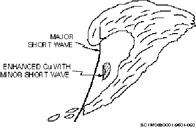
Figure 2–42. Enhanced CU moving through trough pattern.
While the enhanced CU appears as a cloud cluster, you can associate a minor short-wave trough with it. When the enhanced CU begins to take on a comma-cloud shape, it indicates the minor short-wave trough is developing into a major short-wave trough. Figure 2–43 shows an enhanced CU cloud cluster at approximately 25–30° N latitude and 170° W longitude.
Figure 2–43. Enhanced CU.
Cloud cluster moving over the ridge
A minor short-wave trough moving over the long-wave ridge will appears as a small, unorganized cloud cluster projecting from beneath the northern border of the cirrus clouds. As it moves into the base of the long-wave trough, it may take on a comma-cloud shape.
Since the atmosphere is characterized by short waves moving through the long-wave pattern, you can identify both types of wavescan be identified on the imagery. If a short-wave trough is located near a long-wave trough position, determining the exact position of each will beis difficult. The same holds true for long-wave and short-wave ridges.
Combination of upper lows and any of the previous systems
To place an upper trough, you can anchor the northern part of the trough to the upper low (fig. 2–44) and place the southern part of the trough can be placed bywith any of the methods we previously described. This method will allows more accurate placement of the upper trough. This is usually associated with a major short-wave trough.
Upper-level deformation zones
Upper-level deformation zones are significant for the identification of upper-level lows. They reveal important information about the flow pattern aloft. Usually, deformation zones with mid-latitude cyclones develop when the upper low circulation closes off. They occur west to north of upper-level lows. This will forms a col, or neutral point, where easterly or southerly flow opposes westerly flow. Figure 2–45 illustrates some deformation zones associated with comma clouds. Some regions of upper-level difluence are characterized by a spreading band of clouds we called the "fountain" (fig. 2–46).
Figure 2–46. Fountain deformation zone.
Regions of confluence are often associated with the merging of moist and dry-air streams that form the deformation zone. A smooth cloud border normally develops along the boundary between the two air streams as clouds form in the moist air and spread out along the border. The position of this border is useful for identifying the deformation zone.
WV imagery is useful in detecting upper deformation zones (see fig. 2–47). The deformation zone location is marked by a sharp gray shade contrast between dark (dry) and light (moist) regions.
Figure 2–47. WV schematic of upper-level deformation zone.
Upper lows
These are identified by the cyclonic swirl in the cloud pattern and are usually found with the upper-level deformation zone. Around the low is a large amount of vertical cloud development that indicatesing an unstable atmosphere. Extratropical lows are lows that develop outside the Tropics. Lows associated with the comma-cloud structure will beare positioned slightly west of the center of the swirl of upper-level cloudiness within the deformation zone cirrus (see fig. 2–48).
Cut-off lows
Cut-off lows are small, deep pools of cold air located equatorward of the PFJ. Three types of clouds are normally associated with cut-off lows. Refer to figure 2–49 as you read the descriptions of each cloud type.
Figure 2–49. Cloud signatures with cut-off lows.
Baroclinic zone cirrus
Cut-off lows initially have the jet stream oriented with a strong south-north component east of the low center. Baroclinic zone cirrus forms on the equatorward side of the jet stream. This cloud band is similar to the upper-level cloud band you see with lows associated with fronts.
Deformation zone cirrus
This is a band of cirrus that develops due to the flow from the north opposing the southerly flow from the remnants of the upper-level trough. The cirrus is normally stretched in a northeast-to-southwest direction.
Core convection
Core convection is normally observed over water. Air over the ocean will beis most unstable where the upper-air temperatures are the coldest. With cut-off lows, the coldest air is at the center, so convection is most likely to form there.
WV imagery for both types will typically shows a dark slot spiraling around the low. The dark slot indicates drier air and subsidence.
Upper highs
These are associated with anticyclonic cloud curvature. They’re more difficult to position because cloudiness is scarce in the downward vertical motion east of the ridge axis.
Water vapor imagery is particularly useful for identifying closed upper-level highs. With the ridge, we learned the WV imagery will shows a boundary between the moist and dry air. Where this is indicated will depends on the ridge amplitude. As the closed high circulation develops, the inside boundary of moist versus dry air will smoothes out, indicating strong easterly flow. This will beis located in the southern-western-northern quadrants (see fig. 2–50).
Figure 2–50. High positioning.
VIS, FIR, and enhanced IR imagery will show this smoothness. However, it generally will beis seen on WV imagery first.
Vorticity maximums
Vorticity maximums are associated with a cloud pattern known as the vorticity comma cloud. The cloud pattern is located downstream from the vorticity maximum. The precipitation associated with the cloud pattern is convective in nature. Cyclonic wind flow is also associated with the vorticity cloud pattern. Figure 2–51 shows a vorticity cloud pattern. Figure 2–52 shows a vorticity maximum off the coast off Baja, Mexico.
Figure 2–51. Vorticity comma cloud.
Figure 2–52. Vorticity maximum.
The vorticity cloud pattern will variesy in size, shape, and organization. Vorticity maximums are associated with cloud structures such as baroclinic leaves, enhanced CU, and the vorticity comma cloud associated with the synoptic-scale comma cloud. When the vorticity comma cloud is identified with a synoptic-scale comma cloud, it willis also be associated with the cold and occluded fronts and, to some extent, with the warm front.
The vorticity maximum is located approximately 1° of latitude in the clear air away from the inflection point of the "S shape" upstream cloud edge of the vorticity comma cloud (fig. 2–53).
Figure 2–53. Vorticity maximum placement.
The vorticity comma cloud is often hidden beneath the baroclinic and deformation zone cirrus clouds. You must look at the synoptic-scale comma-cloud pattern to place the vorticity center. Place the vorticity center approximately 1° in the clear air to the right of the cusp in the cirrus clouds (see fig. 2–54). The cusp is the equatorward point on the downstream side (inside) of the deformation zone cirrus.
A rapidly translating comma-cloud pattern will havehas an elongated appearance. The vorticity maximum position will remains the same. However, it’ll be is located further back in the clear air, as shown in figure 2–55.
Figure 2–55. Vorticity maximum placement with a rapidly translating comma-cloud system.
Over land, beware of the apparent cloud rotation which indicatesing the vorticity maximum center. The cloud pattern can be very misleading when you trying to place the vorticity maximum. The vorticity center is usually located further back into the clear air than the apparent rotation center. Since there is less moisture available, you can’t usually determine the true vorticity centercan’t usually be determined with 100 percent accuracy. It’s much easier to pick out the vorticity maximum over water, due to the abundance of convective clouds over the moisture source.
Baroclinic leaf cloud patterns
These areis is a vorticity clouds in the westerly wind flow. They’re usually best defined on the downstream side of a high amplitude trough pattern. A baroclinic leaf is caused by mid-level deformation ahead of the jet maximum, upstream from the leaf. The jet stream will cuts across the western end or tail of the baroclinic leaf (fig. 2–56). This may cause a "V" notch signature in the tail of the cloud. If the "V" notch is there, it may be well defined or very ragged in appearance. The baroclinic leaf is typically located in the left-front quadrant of the speed maximum where divergence is strong. It can also be located in the right-rear quadrant of the speed maximum.
Baroclinic leaves generally have a shallow "S" shape on their upstream cloud border. The upstream end of the cloud pattern has cyclonic curvature while the downstream end has anticyclonic curvature. Usually, the vorticity maximum is located approximately 1° into the clear air from the inflection point on the upstream side. The leaf does not move in the direction it’s oriented. It moves with the upper-level winds. Figure 2–57 shows an example of baroclinic leaf movement.
Figure 2–57. Baroclinic leaf movement.
On VIS imagery, cirrostratus cloud tops are predominant in the downstream end while we see mid-level cloud tops are seen on the upstream end. Depending on the time of day, cloud shadows can help you define the cloud types and the changes in coverage.
On FIR, enhanced infrared (EIR), and WV imagery, the colder and smoother cloud tops occur in the wider, forward portion of the leaf. EIR imagery will shows gray shade contouring similar to CS clouds. The cloud mass becomes fragmented and warmer toward the narrow tail, indicating mid-level and possible low-level clouds.
016. Mesoscale convective complex (MCC) and severe thunderstorms
Organized, persistent areas of deep convection are noted in METSAT imagery during the warm season, especially over the US. These systems are MCCs. The MCC usually begins as a group of cells forming within a moist unstable zone in the afternoon hours. The cells continue to grow and merge. Through this process, Llarge amounts of moisture are transported, through this process, into the upper atmosphere. As the moisture spreads and the cells continue to merge and grow, the area begins to appear like one large cell or area on METSAT imagery. These systems continue to grow throughout the night, producing numerous thunderstorms and areas of heavy precipitation. The MCC may contain cells severe enough to produce phenomena associated with severe thunderstorms, but this type of weather diminishes once the nocturnal MCC has develops ed. MCC systems usually have an egg-like appearance with a strong thermal gradient evident in the IR on the right-rear edge with respect to movement. It is in the area of this thermal gradient that most severe weather associated with these systems occurs.
In figure 2–58, an area of afternoon thunderstorms has developed in northeastern New Mexico and southeastern Colorado. An upper-level ridge is located from Louisiana to the Great Lakes. The thunderstorm activity is located in the difluent flow on the upstream side of the ridge. This is the region where most MCC development occurs. By 0300Z (fig. 2–59), the area of thunderstorms has developed into an MCC and moved eastward. The MCC continues to be located in the difluent zone of the upper-level ridge. If any severe weather is associated with this MCC, it would be located near the greatest thermal gradient in northern Texas.
Figure 2–58. Thunderstorms. GOES E visible image, 18 Jul 81, 2130Z.
Figure 2–59. Mesoscale convective complex. GOES E visible image, 19 Jul 81, 0300Z.
A trigger that maintains the MCC is the convergence of the outflow boundaries associated with the individual cells. These outflow boundaries (arc clouds) appear as a curved line of cumulus clouds. They act as miniature cold fronts. Often, like the MCC, these cloud lines merge to form one large arc cloud that extendsing over hundreds of miles. When these arc clouds converge, they tend to initiate the development of new thunderstorms that will beare stronger than the arc cloud’s parent storms. This is due to the combination of the energy fields of the two parent storms into one.
In figure 2–60, numerous outflow boundaries are scattered throughout east Texas, Arkansas, Louisiana, and Oklahoma. After the parent storm dissipates, the residual outflow boundary appears as a clear area encircled by cumulus. Often thunderstorms will develop along the edges of these outflow boundaries, as seen in Oklahoma.
Figure 2–60. Outflow boundaries. GOES visible image, 01 Sep 91, 2028Z.
017. Tropical cyclone analysis
We use Tthe Dvorak method of tropical cyclone analysis is used to determine tropical cyclone intensity from METSAT imagery. The analysis techniques of the past used cloud feature measurements and rules based on a model of tropical cyclone development to arrive at the current and future intensity of a tropical cyclone. The Dvorak method describes tropical cyclone development in terms of day-by-day changes in the cloud pattern of the storm and its environment.
An important observation made during the early years of tropical cyclone analysis using satellite data was of the cloud patterns evolving through recognizable stages as the intensity changed. Generally, the patterns showed the dense (cold) clouds of the disturbance formed around the storm center in the shape of a curved band in the early stages of development. The band was observed to curve halfway around the center in the weak tropical storm stage and completely around the center to forming an "eye" at the weak hurricane stage. Further intensification was indicated by increasing dense (cold) clouds around the eye or by the eye becoming more well defined (warmer). However, the difficulty inherent in following this pattern of evolution lies in the variance of the form and clarity of the pattern with time. Periods of cloud pattern distortion, dissipation, or development of an obscuring central overcast makes it difficult to follow the evolution of the curved bands.
Loops of the METSAT images show the storm development does not evolve continuously from stage to stage but appears to form in surges. During the surges, the storm center generally appears well defined. Following surges, the cloud features become poorly defined. Some reasons for this variability are short-period convective scale activity, diurnal influences, and adjacent circulation impinging on the storm. To cover all the possible changes occurring during storm development, the Dvorak method uses many rules to govern intensity determination. These rules are too numerous to detail and remain within the scope of this text, but a description of the different intensity ratings follows.will be discussed.
The first and most important rule of tropical storm analysis states the pattern formed by the clouds of a tropical cyclone is related to the cyclone’s intensity rather than to the amount of clouds in the pattern. The cyclone’s intensity at any given time is related to the distance the curved band is wrapped (coiled) around the storm center. Figure 2–61 is an example of the model we used to determine the T (tropical) number of the tropical cyclone. We use Tthe T number is used to describe the rate of development or dissipation of a tropical cyclone. The straight line of the graph shows the typical rate of storm development. When the curved band coils around the center at the day-by-day rate, as shown in figure 2–61, the storm is developing at a typical rate. When the curved band coils faster or slower, rapid or slow growth is indicated.
Rate of storm development is expressed as one "T" number per day. The T number is defined by the cloud features of a cyclone related to its intensity. The relationship between the T numbers, wind speed, and central pressure is shown on the left side of the graph. This is a very simplified explanation of T number determination. As we stated earlier, there are many variables.
Figure 2–61. T number model.
Another indicator of tropical cyclone development is the current intensity (CI) number. In operational practice, it is the CI number and not the T number that describes the true intensity of the storm. The CI number is essentially the same as the T number. It isThe two numbers are not only expressed in the same manner (T number 1.5 and CI number 1.5 are the same), they are equal as the tropical cyclone develops. During the dissipation stage, however, the T and CI numbers are different, though the difference is generally small. The CI number tends to remain higher than the T number as the storm dissipates. This is because the clouds associated with the storm will dissipate faster than the central pressure rises or the wind speeds decrease.
The table below shows the relationship between the CI number and the storm’s wind speed and central pressure for the Atlantic and the NW Pacific.
|
CI Number |
MWS (Knots) |
MSLP (Atlantic) |
MSLP (NW Pacific) |
|
1 |
25 |
||
|
1.5 |
25 |
||
|
2 |
30 |
1009 mb |
1000 mb |
|
2.5 |
35 |
1005 mb |
997 mb |
|
3 |
45 |
1000 mb |
991 mb |
|
3.5 |
55 |
994 mb |
984 mb |
|
4 |
65 |
987 mb |
976 mb |
|
4.5 |
77 |
979 mb |
966 mb |
|
5 |
90 |
970 mb |
954 mb |
|
5.5 |
102 |
960 mb |
941 mb |
|
6 |
115 |
948 mb |
927 mb |
|
6.5 |
127 |
935 mb |
914 mb |
|
7 |
140 |
921 mb |
898 mb |
|
7.5 |
155 |
906 mb |
879 mb |
|
8 |
170 |
890 mb |
858 mb |
Self-Test Questions
After you complete these questions, you may check your answers at the end of the unit.
011. Composition of the wind field
_____ 8. The horizontal axis where air parcels are moving away from the col.
012. Upper tropospheric interpretation
1. List the steps involved in using METSAT imagery for upper tropospheric interpretation.?
013. Cloud pattern recognition
1. What are the cloud features that make up a synoptic-scale comma cloud?
2. Which comma-cloud feature is associated with the thickness ribbon on the thickness product?
3. What is another name for the surge region?
014. Upper-level wind flow determination
1. What are the two techniques we used to determine the upper-level wind flow?
015. Synoptic feature identification and placement
1. Where is the jet stream axis located in relation to baroclinic zone cirrus?
2. When no high clouds are present at the jet stream level, where would the axis be located?
3. Where would the jet axis be located with lee-of-the-mountain cirrus?
4. On WV imagery, what would you look for when you trying to locate the jet stream?
5. When a 500-mb short-wave trough intersects a frontal cloud band, what happens to the cloud types and coverages?
6. What METSAT imagery is the most useful in detecting upper-level deformation zones and why?
7. With what cloud structures are Vvorticity maximums are associated with what cloud structures?
016. Mesoscale convective complex (MCC) and severe thunderstorms
1. What type of appearance do MCC systems usually have?
2. What trigger maintains the MCC?
017. Tropical cyclone analysis
1. What is the first and most important rule of tropical storm analysis?
2. What are the different intensity ratings that the Dvorak method uses?
In this section, you’ll learn how to determine low-level wind flow and synoptic features. The methods and ideas we used in the previous sections will continue to hold true in this section.
018. Lower tropospheric interpretation
You’ll fFollow the same steps for lower tropospheric interpretation as you did with upper tropospheric interpretation. First, there is cloud pattern recognition, then you determine wind flow from specific cloud and non-cloud phenomena, and finally, you analyze for specific synoptic systems.
When you interpreting the lower troposphere, you can also use the terrain’s effects on clouds to determine low-level wind flow and identify synoptic systems. Mountains, islands, and lakes change the cloud patterns, providing many valuable clues for your analysis.
019. Cloud pattern recognition
The same reason you recognize cloud patterns for upper-level features and use them in analysis applies to cloud pattern recognition for low-level features.
Fronts
Cold, warm, occluded, and stationary fronts are the surface features associated with the comma cloud structure. Cloudiness ranges from an organized area of thick, multilayered clouds at the comma head to the central portion of the comma cloud structure to fragmented, low-level clouds at the tail end of the comma tail. Cyclonic wind flow is associated with the cold, warm, and occluded fronts. The wind flow is light and variable with stationary fronts.
Lows
Look at the cyclonic swirl of low-level clouds within the mature comma cloud to place an extratropical low. Initially, with extratropical lows, the surface low cannot be positioned because it’s embedded in multilayered cloudiness (baroclinic zone clouds).
Highs/ridges
Due to the general stable atmosphere associated with highs and ridges, you’ll normally see stratiform cloudiness around the high. Occasionally, you see cumulus cloudsare seen to the west and north of the high center. The clouds surround the high center, which is typically clear. The combination of these clouds and how they’re affected by the terrain (blocking, cloud shape changes, etc.) will helps you determine the wind flow. This information allows you to position the high center and ridge axis.
Low-level deformation zones
These are the easiest to see over the water. They are commonly found at the tail end of the comma cloud. Open and closed-cellular clouds are the best indicators of a low-level deformation zone behind the cold front. Figure 2–62 shows the wind flow around a low-level deformation zone.
Figure 2–62. Low-level wind flow.
020. Low-level wind flow determination
The atlas is an essential tool for evaluating low-level wind flow. Knowing the terrain in a region helps tremendously when you analyzeing the wind flow in the lower troposphere. For example, clouds can be blocked by hilly or mountainous terrain. When you analyzeing METSAT imagery, open your atlas to the area in question.
When we determineing lower tropospheric wind flow, we’ll interpret specific cloud and non-cloud phenomena, and the empirical wind observations indicated by these features. First, look at the cloud organization and alignment within the general synoptic pattern. Second, determine the interaction of the clouds with the changing terrain. Keep in mind the flow being analyzed is at the cloud base level and isn’t necessarily the same as the surface wind. Thus, you must consider the strength of cold-air and warm-air advection, when applicable.
Empirical wind observations indicated by cloud organization and alignment
Since METSAT data has been used, we have learned clouds around the world provide us useful wind direction and speed information. In this lesson, you’ll learn how to use these empirical techniques to make wind flow determinations.
Open-cell cumulus
Straight-line or cyclonic flow is associated with these clouds. Straight-line flow is along the border of the open-cell CU and closed-cell SC. Cyclonic flow will beis seen in the rest of the open-cell CU field.
You can determine Wwind speedscan be determined using the following criteria:
Figure 2–63 shows the different shapes that open-cell CU may have.
Figure 2-63. Open-cell CU shapes.
Closed-cell SC
The wind flow is anticyclonic with this cloud pattern. You cannot determine Tthe general wind direction cannot be determined until you define all the other synoptic features around the closed-cell SC. Generally, the wind speeds are less than 20 knots.
Stratocumulus lines
SC lines are seen off the eastern and southern coastlines of continents and large lakes. The wind flow is parallel or nearly parallel to the cloud lines. The winds can be cyclonic, anticyclonic, or straight-line.
You can also determine the wind speeds from SC lines. The smaller the cloud elements, the stronger the wind will be. So aAs the winds decrease, the cloud elements will get larger. If a separation is visible between the SC lines, the wind speeds are greater than 20 knots. If no separation is visible, then the winds are less than 20 knots.
CU lines/streets
The wind flow is parallel or nearly parallel with CU lines/streets. These willare mainly be seen in the tropical and subtropical regions.
Smoke/ash/dust
These can be seen at different levels in the atmosphere. You’ll need observations from the area to determine the height of the phenomena. To determine the wind direction, find the sharp cloud boundary; and this will beis your upstream side. Downstream, the phenomena will become more diffuse.
NOTE: Behind a strong cold front, blowing dust can spread out cyclonically and anticyclonically in the low-level deformation zone. There will beis a sharp definition on the upstream side of the dust cloud. Here, the upstream boundary of the dust cloud is not a good indicator of the wind direction.
Ship trails
You’ll see these under very stable, high-pressure conditions, which causes. So the flow willto be light and anticyclonic. Continuity of the ship trails’ movement will allows you to determine the general wind direction.
Empirical wind observations associated with terrain features
The interaction of clouds or lack of clouds with terrain can give you information on the wind direction and speed.
Upslope/orographic lift
The wind flow forces moisture up higher terrain. The moisture will condenses and, depending on the stability of the air mass, will forms specific cloud types. You can determine Ggeneral wind flow can be determined by using this feature with other information.
Unstable
A front moving through the Rockies may be associated with convective cloudiness. This would beis due to air being forced up the mountain and the instability associated with the front.
Stable
A high-pressure system over the central and southern US will brings moisture in the form of fog/stratus and SC against the eastern slopes of the Rockies and the western slopes of the Appalachians (see fig. 2–64).
Figure 2–64. Orographic lift/upslope.
Leeside clearing
Leeside clearing is very common along the eastern slopes of the Rocky and Appalachian Mountains. It indicates winds are crossing the mountain ridge line at an angle greater than 45° . On the leeside of the mountains, the winds are cyclonic.
Lake effect
The effect the moisture from lakes has on cloud patterns is significant. Wind flow is parallel to the axis of the patterns that we will be discussinged. Keep in mind the strength of the air masses moving across the lake and the season in which it’s happening.
Summer
Cumulus clouds developing upwind over warmer land will dissipate as they move over the relatively cooler lake. This will forms a cloud-free area downstream over land for a distance before more clouds begin to develop with surface heating.
Winter
Colder, drier air moving over a relatively warmer, mostly unfrozen lake will forms stratocumulus (SC) lines over the lake and downstream over the land. There is a cloud-free region on the upstream side of the lake.
Ice packs on large lakes and seas
Regions of ice will beare pushed away from the upstream shore by low-level winds which persisting over the area for long periods. A narrow black line showing the location of open water or newly formed ice will results as the old ice pack is pushed away from the shoreline. Ice will beis then packed against the downstream shore. It’s more useful to look at the downstream shore of a lake or sea to determine low-level winds when the ice is newly formed. The reason is the ice will beis blown into the shore by the prevailing winds.
Bow waves/plume clouds/Karman vortices
These phenomena are caused by wind flow interacting with an island or peninsula in the ocean. By locating the island and phenomena, then looking downstream, you can determine the general low-level synoptic wind flow.
021. Synoptic feature identification and placement
You’ll uUse the information from the previous techniques to help analyze for pressure systems and low-level deformation zones. Also, remember to follow continuity to help you track the systems.
Fronts
Fronts are normally located within the comma cloud structure or an organized multilayered cloud band. Usually with METSAT imagery, you can only place the general position of the front so the techniques you’ll learn are a general guide and not a foolproof positioning technique. To get an accurate frontal position,you need to use conventional synoptic data. Fronts are usually easier to identify over water than land because more moisture is available for cloud formation along the frontal boundary.
Cold fronts
Typically, a cold front is located under the multilayered, baroclinic zone cirrus of the comma cloud structure. If you do not have synoptic reports, the following technique will help you maintain continuity of a cold front until conventional reports become available. Place the cold front near the back edge of the comma head. Draw the front toward the comma tail, gradually transitioning from near the back edge of the comma head to the leading edge on the end of the comma tail (see fig. 2–65). Along the tail end and, over water, there is usually a rope cloud that will shows the exact frontal position. The rope cloud is just a line of low-level convergence with little weather associated with it.
Figure 2–65. Cold front placement.
Along a cold front, you’ll see stratiform clouds with convective clouds embedded. Ahead of the front, there is usually a mix of scattered stratocumulus and cumuliform clouds. Behind the cold front over water, you’ll see an open- and closed-cellular cloud pattern. Over land, it normally is clear or you have scattered low clouds.
Warm fronts
Warm fronts are more difficult to position because the cloudiness ranges from scattered clouds to multilayered clouds (baroclinic zone cirrus cloud shield). The amount and type of cloudiness depends on the amount of available moisture and the stability of the warm air. The PFJ turns anticyclonically on the cold side of the warm front.
The surface front is typically located within the notch or wedge on the warm side of the baroclinic zone cloud shield, as shown in figure 2–66. Sometimes, there may be convection on the warm air side of the warm front. This will appears a little more fragmented with thicker baroclinic zone cloudiness on the cold air side of the warm front.
Figure 2–66. Warm front placement.
Occluded fronts
Position the occluded front along the back edge of the comma cloud head (see fig. 2–67). Draw the front back to the northern half of the low, but not into a low with well-developed comma clouds.
Figure 2–67. Occluded front placement.
You can locate the triple point two different ways. If the PFJ cuts eastward across the comma cloud, there will beis a sharp cloud boundary between the baroclinic zone cirrus on the equatorward side of the PFJ and the AS/AC (vorticity-induced cloud) below and on the poleward side of the PFJ. The triple point has been empirically located on the equatorward side of this boundary near the back of the upstream cloud edge of the baroclinic zone cirrus. On WV imagery, there will beis a slight gray shade difference between the two cloud layers.
If the PFJ does not cut across the comma cloud, you can extrapolate the warm and cold fronts until they meet. Do Tthis is only done only if you do not have any, or very little, conventional data with which to place the triple point. Figure 2–68 shows an example of how to place the triple point.
Figure 2–68. Triple point placement.
Stationary fronts
The cloudiness with stationary fronts will ranges from thick, multilayered clouds to fragmented, scattered clouds. Place the front along the leading edge of the cloud band. Over water, you’ll usually have a rope cloud, which is a good indicator of the front. Clouds are normally cumuliform on the warm side of the front, while more stratiform type cloudiness is on the cold air side (fig. 2–69). The type of cloudiness depends on the stability of the warm air.
Figure 2–69. Stationary front placement.
Extratropical lows
We’ll concentrate on lows associated with the comma cloud pattern and the low’s placement in different stages of development
Initial stage
On a slow-moving cold front or stationary front, the frontal clouds will begin to widen and have a slight "S" shape on the poleward side of the cloud band. On FIR and EIR imagery, clouds will begin to show cooler tops, which indicatesing increased upward vertical motion. With WV imagery, gray shade contrast will becomes more distinct as the short-wave trough begins to interact with the front, increasing the divergence aloft. You can locate Tthe surface lowcan be located approximately halfway into the cloud pattern from the inflection point in the frontal cloud band (fig. 2–70).
Figure 2–70. Initial low stage.
Intensification stage
As the low intensifies, the synoptic-scale comma cloud will becomes larger and better defined with a developing dry slot (cloud minima zone or surge region). The dry slot will begins to wrap around the upper low. The surface low will translates along the back edge of the comma head (fig. 2–71). The comma head is composed mainly of the vorticity comma cloud.
Figure 2–71. Low intensification stage.
Mature stage
The surface low is starting to become vertically stacked with the upper-level low. The surface low will beis located in the eastern portion of the deformation zone cloud (fig. 2–72). Often, the deformation zone cirrus and the dry slot have wrapped around the low.
Figure 2–72. Mature low stage.
Dissipation stage
During this stage, the surface low fills and is usually not identifiable on METSAT imagery.
Highs and ridges
These two features are normally discussed together when we talk about interpreting METSAT imagery. Their positions are based mainly on low-level cloud indicators and terrain influences on the clouds surrounding the high center and ridge axis.
Baroclinic highs and ridges over land
Positioning these over land is very difficult because there is usually not one indicator that givesing you the exact location. You must rely on a combination of indicators to give you a general location of these features.
Some features you can use to position baroclinic highs and ridges during the different seasons follow. Remember, look at these features in a big picture perspective.
Late fall to early spring
To find the position of the high or ridge,you’ll need to determine the low-level wind flow around them first. Use SC lines off lakes and coastlines east of the high, ice movement, and mountain waves. You can also use fog/stratus and SC that is being pushed up against higher terrain south and west of the high to determine the anticyclonic wind flow. These clouds typically suggest stable conditions.
Mid spring to mid fall
Use the clearing of clouds on the leeside of lakes, fog/stratus, SC and convective clouds that are being pushed up against higher terrain and mountain waves to determine low-level anticyclonic flow. Another indicator is the clearing of clouds in the eastern half of the high with convective clouds occurring in the western half , and showing anticyclonic flow. Place the surface ridge axis in the strongest anticyclonic turning within the CU line/street field. This cloud signature is common in the Midwestern and southern US.
In the middle latitudes, the surface high will havehas an upper-level short-wave ridge axis located on its upstream side. Upper-level cloudiness associated with the next upstream system normally will extends over the upper-level ridge axis to the approximate surface high position (see fig. 2–73). In extratropical regions, when you see a well-developed low and front, there is a surface high or ridge located upstream.
Figure 2–73. Surface high with upper-level clouds.
High centers and ridge axis over water
It’s easier to position these features over water than over land because of the large amount of moisture available for cloud formation.
Extratropical systems
A high center and ridge axis can be positioned behind a cold front with a combination of cloud patterns, terrain influences, and the low-pressure center location. In the southern half of a high, you normally see closed-cell SC with a clear zone to the west. West of the clear zone is usually another frontal system with low-level clouds converging into it. The high center is normally located in the eastern portion of the clear zone (fig. 2–74). Place Tthe ridge axis is placed where the clouds show the strongest anticyclonic turning.
Determining the low-level wind flow from SC lines, the packing of clouds against islands and terrain, bow waves, plume clouds, Karman vortices, CU lines/streets, and the movement of anomalous cloud lines will helps you position the high center and ridge axis.
When two frontal systems come in close proximity, a sharp surface ridge is found between them (fig. 2–75). On the northern side of the surface high, windswill shift from southwesterly or westerly to northwesterly or northerly. The surface ridge axis is positioned along a line where the CU clouds first develops in the low-level cold air that hashaving a northerly component over warmer water. This line is usually coincident with the forward edge of the overcast clouds from the upstream storm system moving over the upper-level ridge.
Figure 2–75. High placement with cumulus clouds.
Subtropical high
This high is centered over the water and extends over the continents. The high center ranges from approximately 28°N to 35°N. The mean ridge axis is typically in an east-to-west orientation. In the middle latitudes, you’ll also see a ridge axis oriented in a northerly direction.
You can identify Tthe subtropical highcan be identified on METSAT imagery by considering the flow pattern in the surrounding region. Systems within the PFJ flowwill generally move from west to east. Tropical systems to the south will move east to west. East to southwest of the high center, closed-cell SC is usually present, which is commonly seen off the west coasts of continents. To the west of the high, you’ll see anticyclonically curved CU lines/streets. Place the ridge axis in the center of the strongest anticyclonic turning.
The cumulus cloud elements on the poleward side of the ridge axis are typically smaller than the cumulus cloud elements on the tropical side. Cloud elements on the poleward side may even be SC.
Cloud fingers are SC clouds that protrude from the equatorward side of the cold front. At the extreme end of the cloud finger is where the surface ridge axis has been empirically observed. Figure 2–76 shows the placement of the ridge axis with cloud fingers.
The ridge axis has been empirically observed within the "V" notch in the sun glint pattern. You’ll have either one or two "V" notches. Where the cloud fingers end and the sun glint begins is where the ridge axis is. The movement of anomalous cloud lines, terrain blocking, bow waves, plume clouds, and Karman vortices will helps you determine the position of the high center and ridge axis.
Low-level deformation zones
Low-level deformation zones are formed for the same reasons as upper-level deformation zones. Opposing wind flow will diverges between two high-pressure systems and converge leading into one of two low-pressure systems.
On METSAT imagery, Aa low-level deformation zone is most evident on METSAT imagery over water behind cold fronts with open and closed-cellular cloud patterns. Visual imagery is normally the best imagery to use for deformation zone analysis. Open-cell CU indicates straight-line and cyclonic flow, while closed-cell SC indicates anticyclonic flow. Between the cold front and the cellular clouds, you may also see a band of low clouds that are perpendicular to the flow (fig. 2–77). Ahead of the front, analyze for any indicators that would help you determine the low-level wind flow. Along the front, normally a rope cloud will indicates where the low-level wind flow converges.
Figure 2–77. Low-level deformation zone.
Self-Test Questions
After you complete these questions, you may check your answers at the end of the unit.
018. Lower tropospheric interpretation
1. What effect do youis considered when you interpreting the lower-level wind flow that is not considered in upper-level wind flow analysis?
2. What type of terrain offers clues in analyzing the lower troposphere?
019. Cloud pattern recognition
1. Why is the extratropical surface low hard to position initially?
2. Where are low-level deformation zones commonly found?
020. Low-level wind flow determination
1. Why is an atlas an essential tool for evaluating low-level wind flow?
Column A _____ 1. Straight-line or cyclonic flow associated with these clouds. _____ 2. You see these under very stable, high-pressure conditions with light, anticyclonic flow. _____ 3. Behind a strong cold front, this can spread out cyclonically and anticyclonically in the low-level deformation zone. _____ 4. The wind flow is parallel or nearly parallel, but these clouds are mainly seen in the tropical and subtropical regions. _____ 5. These are seen off the eastern and southern coastlines of continents and large lakes with a parallel or nearly parallel wind flow. |
Column B a. Ship trails. b. Blowing dust. c. Open-cell cumulus. d. Stratocumulus lines. e. Cumulus lines/streets. |
3. What phenomena are caused by the wind flow interacting with an ocean island?
021. Synoptic feature identification and placement
Column A _____ 1. Place the front along the leading edge of the cloud band. _____ 2. The PFJ turns anticyclonically on the cold side of this front. _____ 3. This front is positioned along the back edge of the comma cloud head. _____ 4. Over water, along the tail end there is usually a rope cloud that shows the exact frontal position. |
Column B a. Cold front. b. Warm front. c. Occluded front. d. Stationary front. |
Column A _____1. The surface low is located in the eastern portion of the deformation zone cloud. _____2. During this stage, the surface low is usually NOT identifiable on METSAT imagery. _____ 3. On infrared imagery the clouds begin to show cooler tops indicating increased upward vertical motion. _____ 4. The surge region begins to wrap around the upper low with the surface low translating along the back edge of the comma head. |
Column B a. Mature stage. b. Initial stage. c. Dissipation stage. d. Intensification stage. |
3. Why is it easier to position high centers and ridge axes over water than land?
4. What is the best METSAT imagery to use for low-level deformation zone analysis?
The atmosphere always has flow occurring in the vertical and horizontal. In this section you’ll look at the vertical and horizontal motions and what is causing these motions. You’ll learn the relationship of vertical and horizontal motions to low-pressure systems.
These may develop into a synoptic comma cloud. The following diagrams are composites of a typical comma cloud (figs. 2–78 and 2–79). There will beare often variations to this pattern from system to system.
Figure 2–78. Upper-level features and flow with the comma cloud.
Figure 2–79. Low-level features and flow with the comma cloud.
Conveyor belts
We use Cconveyor belts are used to explain the horizontal and vertical movements of an air parcel simultaneously with a comma cloud. Your understanding of the air flow with the comma cloud and the cloud types associated will improve your analysis and forecasting skills.
Warm conveyor belt (WCB)
Baroclinic zone cirrus is associated with the northern portion of the WCB. Baroclinic zone cirrus composes the eastern and, frequently, the central portion of the comma head. Except for possible convection along the cold front, the coldest (highest) cloud tops are associated with the WCB.
Cold conveyor belt (CCB)
Low clouds may be associated with the CCB ahead of the warm front. Near the low center, mid- and upper-level clouds form when the CCB sharply ascends. The CCB forms the comma head.
Dry-air conveyor belt (DACB)
The DACB does not cause any cloudiness. However, it does affect the cloudiness associated with the WCB and CCB. As the DACB nears the low, it splits into two branches. One branch turns cyclonically and flows just northwest of the WCB. You can see Tthe boundary between the two conveyor beltscan be seen on VIS and IR imagery as a smooth high cloud border north of the low. On WV imagery, you’ll see a gray shade contrast between the moist air (light gray) and the dry air (dark gray). The other branch turns anticyclonically and descends behind the low. Figure 2–80 shows the relationship between the comma cloud and the conveyor belts.
Figure 2–80. Conveyor belt relationship to the comma cloud.
PFJ relationship to the comma cloud
The jet stream axis is associated with the comma cloud system. Two patterns are possible.
Type A
The PFJ is continuous and crosses the comma cloud system at, or north of, the triple point. The PFJ separates baroclinic zone cirrus from deformation zone cirrus. Deformation zone cirrus is typically lower and thinner than the baroclinic zone cirrus. The vorticity comma cloud is visible on the poleward side of the PFJ axis.
Type B
The PFJ is not continuous through the comma cloud system. The PFJ wraps around the upper-level low and weakens. It reforms north of the warm front at the top of the comma cloud and extends eastward. The baroclinic and deformation zone cirrus have merged. The deformation zone cirrus is approximately the same height as baroclinic zone cirrus and is much thicker.
PFJ speed maximums
The PFJ lies in the dry slot (surge region) associated with the comma cloud system. There is a speed maximum located within the dry slot on the equatorward side of the 500-mb low (fig. 2–81).
Figure 2–81. Speed maximum relationship to the comma cloud.
On VIS and IR imagery, the dry slot is cloud free in the upper levels. The PFJ lies in this region. There may be low SC or CU clouds located in this area. The dry slot will appears as a dark band on the WV imagery. The dry slot will wraps around the upper low. Typically, a speed maximum is located in the darkest portion of the dark band. Using figures 2–82 and 2–83, you should be able to place a speed maximum in the Kentucky/Indiana border area.
Figure 2–82. Speed maximum on water vapor imagery, 1400Z, 14 April 1983.
Figure 2–83. Speed maximum on water vapor imagery, 0500Z, 15 April 1983.
On the poleward side of the comma cloud, downstream from the upper-level ridge axis, there is normally another speed maximum. METSAT imagery will havehas the same gray shade appearance as with the dry slot (see fig. 2–81).
Vorticity relationship to the comma cloud
Understanding the vorticity relationship to the comma cloud is useful for two reasons. The first is to determine accurately what the weather pattern is in comparison to the products. The second is to conduct the initialization and verification process with the models.
Shear lobes
These are normally seen with speed maximums. There is a vorticity maximum located on the poleward side of the speed maximum. The 500-mb low is located on the poleward side of the vorticity maximum, with respect to the vorticity maximum’s direction of movement. Figure 2–84 illustrates this relationship.
Divergence, indicated by PVA, is located downstream from the vorticity maximum, in the left-front quadrant of the speed maximum. If enough moisture is available, upward vertical motion can lead to the vorticity comma cloud development. On METSAT imagery, the coldest cloud tops are typically located in the area of maximum upward vertical motion.
Figure 2-84. Shear lobe relationship to the vorticity comma cloud.
Convergence, which is indicated by NVA, is located upstream from the vorticity maximum, in the left-rear quadrant of the maximum. Downward vertical motion will leads to clearing of the clouds behind the comma cloud. This clearing is also associated with the dry slot.
Advection lobes
A major short-wave trough and ridge couplet are associated with a synoptic comma cloud system. Typically, there are vorticity advection lobes associated with the trough and ridge. When you viewing METSAT imagery, you can determine what vertical motions are occurring around and within a synoptic comma cloud.
Downward vertical motion is occurring upstream from the advection lobe associated with the trough (fig. 2–85, area 1) and downstream from the advection lobe associated with the ridge (fig. 2–85, area 2). Cloudiness has either dissipated or is dissipating in these areas. These areas are associated with convergence aloft and/or cold-air advection (CAA).
Figure 2–85. Advection lobe relationship with the comma cloud (vertical motions).
Upward vertical motion is occurring between the trough and ridge (fig. 2–85, area 3). Cloudiness is typically multilayered and covers an extensive area. This area is caused by divergence aloft, warm-air advection (WAA), and air being lifted in association with the front.
Thickness relationship to the comma cloud system
The surface low becomes removed from the warm air mass at low levels (occluded) as it continues to develop back into the cold air.
Strong CAA is occurring behind the surface low. CAA helps create downward vertical motion besides convergence aloft. This helps lead to the formation of the dry slot. The orientation of the PFJ will determines where the clouds are located in relation to the surface front.
WAA is occurring ahead of the surface low. Typically, a thickness ridge is located just downstream from the surface low. WAA causes the strong lift of the WCB north of the warm front. The type of cloudiness seen on the METSAT imagery will depends on the stability of the warm air.
023. Life cycle of a baroclinic low (frontal wave stage)
In this lesson, you’ll learn how the cloud patterns relate to the life cycle of a baroclinic low. Often synoptic data may be missing or you’re not able to receive it. Knowing how to analyze METSAT imagery allows you to continue to forecast with confidence. Use figures 2–86 through 2–93 as reference imagery while you study this lesson.
Figure 2–86. Upper low in CO developing—note how upper-level deformation zone intensifies, 2200Z, 16 May 1983.
Figure 2–87. Upper low in CO developing—note how upper-level deformation zone intensifies, 0100Z, 17 May 1983.
Figure 2–88. Upper low in CO developing—note how upper-level deformation zone intensifies, 0400Z, 17 May 1983.
Figure 2–89. Upper low in CO developing—note how upper-level deformation zone intensifies, 0500Z, 17 May 1983.
Figure 2–90. Upper low in CO developing—note how upper-level deformation zone intensifies, 0730Z, 17 May 1983.
Figure 2–91. Upper low in CO developing—note how upper-level deformation zone intensifies, 1000Z, 17 May 1983.
Figure 2–92. Upper low in CO developing—note how upper-level deformation zone intensifies, 1600Z, 17 May 1983.
Figure 2–93. Upper low in CO developing—note how upper-level deformation zone intensifies, 2000Z, 17 May 1983.
Classic case
We’ll discuss the cloud pattern and the associated synoptic features as they relate to the classic self-development situation. Remember, there are many variations in appearance but the basic pattern is generally the same.
Initial stage
When a baroclinic low initially develops along a front, the baroclinic zone cloud system (frontal cloud band) will begins to widen on the METSAT imagery. On the cold air side of the widening baroclinic zone, there will beis a slight "S" shape to the cloud pattern. The PFJ is located on the cold air side of the baroclinic zone clouds. Convective activity is often more widespread and organized near the surface low.
The thickness product will shows weak thermal advection ahead and behind the surface low. However, a strong thermal gradient exists. The vorticity product may indicate weak divergence above the cloud band. Over water, open-cell CU clouds may begin to show the low-level circulation developing. Cumulus clouds will begin to flow into the developing low.
Intensification stage
The comma cloud pattern will indicates increased horizontal and vertical motions as the self-development process occurs. Multilayered clouds will increase in area, thickness, and organization.
Baroclinic zone clouds (frontal cloud bands)
As the self-development process begins, the "S" shape of the widening cloud band will becomes better defined. The PFJ speed maximum and vorticity maximum are located upstream. As development continues, the cloud band will takes on a wave appearance. This is the comma head developing. The wave appearance in a cloud pattern is similar to how an ocean wave looks as it develops. As the ocean wave becomes larger, the top of the wave begins to curl cyclonically and wrap in. As the baroclinic zone cloud system becomes larger and wraps, it will haveexhibits this same wave appearance. It will begins to curl, cyclonically, and to wrap around and toward the vorticity maximum. Cloud-top temperatures will decrease as the cloud heights increase. They indicate upward vertical motion is increasing as the system develops. Baroclinic zone clouds may or may not merge with the deformation zone clouds.
Vorticity comma clouds
The vorticity comma cloud is associated with a vorticity maximum and either a shear lobe or an advection lobe. The vorticity comma cloud can be located in one of two areas in relation to the baroclinic zone clouds. It can develop within the baroclinic zone cloud system. It can also be just upstream of the baroclinic cloud system. As the vorticity comma cloud develops, it will moves under and merges with the baroclinic zone clouds.
If the vorticity comma cloud develops within the baroclinic zone clouds, it will also havehas a well-defined "S" shape on its cold air side. As it develops, itwill waves back into the cold air and wraps around the upper low and 500-mb vorticity maximum. The vorticity comma cloud’s development indicates increased divergence and upward vertical motion.
If the vorticity comma cloud develops just upstream from the baroclinic zone clouds, the vorticity comma cloud will initially havehas a well-defined "S" shape on the cold air side of the cloud pattern. As the vorticity comma cloud begins to wrap around the vorticity maximum, the baroclinic zone clouds are waving back and the two cloud systems merge, forming the synoptic comma cloud. The vorticity comma cloud may be either a baroclinic leaf, enhanced CU, or just mid-level cloudiness.
Trough/ridge pattern
Increasing amplitude between the trough and downstream ridge can be related to the changing size and organization of the baroclinic zone clouds and the vorticity comma cloud pattern. Also the ridge will increases its amplitude due to WAA ahead of the surface low and into the upper-level ridge. The increasing sharpness of the ridge will beis evident in the baroclinic zone clouds.
Deformation zone cirrus
Deformation zone cirrus typically forms toward the end of the intensification stage or in the mature stage. Deformation zone cirrus develops in the northern portion of the trough as it amplifies and begins closing off into a low. On VIS and IR imagery, the deformation zone cirrus will initially appears thin and ragged. As the low intensifies, horizontal and vertical motions will increase around the low. As the vorticity comma cloud enlarges, the associated upper-level clouds will wrap around the vorticity maximum, developing more deformation zone cirrus.
Deformation zone cirrus will initially appears as a slight gray shade contrast north and east of the low on the WV imagery. The dark band is parallel to where the axis of dilatation is. Usually the WV imagery will displays the deformation zone pattern before the cloud shows up on VIS and IR imagery.
Dry slot
The dry slot is evident on the upstream side of the "S" shape of the vorticity comma cloud. The dry slot will becomes more evident as the surface low develops and the synoptic comma cloud system organizes. On WV imagery, the dark band will becomes longer, wider, and darker. Before the baroclinic low reaches the mature stage, the dark band will curves cyclonically within the comma head. This depends on whether the comma cloud is developing into a type A or type B system.
Low-level deformation zone
Over water, as the surface low and upstream surface high develop and intensify, the low deformation zone may become more evident in the cloud field. The open-cell CU and closed-cell SC will increase in organization and area.
Mature stage
The mature baroclinic low will beis identifiable in the upper levels by the dry slot that wraps around the low. The farther the dry slot wraps around the low, the deeper and older the system will be. WV imagery will shows the dark band wrapped around the upper low. WV imagery will also shows the dark band with the upper deformation zone has become more defined. The surface low begins to move under the upper low. Over water, you can see the surface lowmay be seen with the cyclonic turning in the open-cell CU field. The comma cloud will beis at its largest size and most organized.
Dissipation stage
The upper low and surface low will become vertically stacked. Over land, the surface low may not be identifiable in the SC cloud field. Over water, you see the surface low is seen in the low-level cumulus and stratocumulus cloud field. Since the surface low will fills before the upper low, it gradually becomes less evident in the cloud field. Cloudiness will beis more circular since the low is more circular. The clouds will gradually thin and dissipate as the entire system fills and upward vertical motion decreases. Sometimes a new low may begin developing along the trailing cold front and the process begins again.
Variations of cyclogenesis
There are a variety of scenarios where cyclogenesis can occur. Different cloud patterns and abrupt changes in zonal flow will increase your chances for recognizing these situations before they occur or are apparent on upper-air products.
Baroclinic leaf cloud pattern
This cloud pattern has proven very reliable since it was discovered on METSAT imagery. It takes on a variety of shapes and can either be poorly organized or very well defined.
Characteristics
The significance of the baroclinic leaf pattern is that 75 percent of them develop into comma clouds. More than 60 percent of all comma clouds develop from the baroclinic leaf pattern.
There are three ways a baroclinic leaf can develop into a comma cloud:
The baroclinic leaf is a cloud pattern associated with the frontogenetic phase of system development. Surface cyclogenesis typically begins as the baroclinic leaf transitions into the comma cloud. The baroclinic leaf will havehas an advection lobe associated with it on the poleward side of the cloud edge. A shear lobe will beis associated with the upstream speed maximum (fig. 2–94).
Figure 2–94. Vorticity and PFJ relationship with the baroclinic leaf.
Previously, you located the baroclinic leaf in the left-front quadrant of the PFJ speed maximum. As the baroclinic leaf begins its transition to a comma cloud, the vorticity and PFJ pattern also changes (fig. 2–95). The PFJ will reorients and flows through the cloud pattern. The older branch of the PFJ is still located equatorward of the baroclinic leaf. A downstream shear lobe may be apparent on the vorticity product.
Figure 2–95. Vorticity/PFJ change with the baroclinic leaf.
Development of a baroclinic leaf
Figure 2–96 and the following discussion shows the typical development process of a baroclinic leaf. From system to system, there will beare variations in cloud patterns, synoptic feature location, and rate of development.
Figure 2–96. Baroclinic leaf pattern.
12Z (fig. 2–96, a). This is the classic baroclinic leaf signature we have discussed earlier. NOTE: The coldest cloud temperatures are unshaded in all diagrams.
15Z (fig. 2–96, b). The cyclonic portion (upstream end) of the leaf tail has begun to dissipate as the speed maximum digs into the cloud pattern. The convex (downstream) portion remains well defined while the southern border has sharpened. Surface frontogenesis is occurring along the western half of the southern border.
18Z (fig. 2–96, c). Most of the concave part of the northern border has dissipated, leaving a ragged, less well defined northern cloud edge to the developing comma tail. The narrowing of the comma tail and the formation of the dry slot during the transition to a comma cloud indicates the PFJ and the speed maximum are flowing into the developing comma cloud. A surface low center consolidates and surface pressures will begin to fall.
21Z/00Z (fig. 2–96, d and e). The comma cloud is in the cyclogenetic phase and the system will continues to develop to maturity and dissipation.
Cold-air vortex
There are four phases to this type of development.
Phase one
Located downstream from a long-wave or major short-wave trough is a baroclinic zone cloud shield and jet stream axis. A new short-wave trough is approaching the old baroclinic zone from the west. The new short-wave trough is typically associated with mid-level and some upper-level clouds. The new trough is apparent on METSAT imagery as a vorticity comma cloud or a baroclinic leaf. A branch of the PFJ will beis associated with the baroclinic zone cloud shield. A new branch of the PFJ is associated with the short-wave trough. If the newer branch of the PFJ merges with the downstream PFJ, cyclogenesis will typically occurs along the baroclinic zone cloud band as we described earlier. If the newer branch of the PFJ curves around the trough and becomes parallel to the downstream (older) PFJ, cyclogenesis will follows the cold-air vortex pattern.
Phase two
If the new jet remains parallel to the old jet, development will continues as follows. The short-wave trough amplifies as it moves through the long wave. The mid-level clouds associated with the smaller trough will begin to form the vorticity comma cloud. Convection will increases with the vorticity comma cloud, resulting in higher cirrus clouds. The PFJ is parallel to the downstream branch of the PFJ. Several lows may be evident with a surface trough associated with the cloud pattern.
Phase three
A synoptic comma cloud pattern is becoming evident as baroclinic zone clouds form on the equatorward side of the new PFJ axis over the intensifying vorticity comma cloud. The cloud pattern shows the increased amplitude of the developing short-wave trough. As the trough increases amplitude, the older baroclinic zone clouds parallel the developing cloud pattern. This cloud pattern begins to weaken and thin as the new development occurs to the west. A surface cold and warm front develop with a consolidated surface low.
Phase four
The new synoptic comma cloud has completely formed with the development of deformation zone clouds in the upper levels. An upper low has developed, helping form the deformation zone clouds. The old baroclinic zone will continues to weaken, thin, and become fragmented. The downstream branch of the PFJwill weakens while the newer branch becomes more dominant. This cyclogenesis often develops into intense type B systems.
Analysis information
here are tTwo other pieces of information you can interpret from METSAT imagery . They are estimating sea-level pressure and determining the strongest wind regions with lows. Empirically, both of the techniques we’ll discuss have proven fairly reliable.
Estimating sea-level pressures of baroclinic lows over the ocean
You can estimate Ssea-level pressure (SLP) can be estimated for baroclinic lows with comma clouds from 40°N and poleward. If the system is very strong, you can estimate sea-level pressurecan be estimated further south. This technique assumes environmental pressures at the beginning of development are above 1000mb. If the SLPs are below 1000mb at the beginning of development, adjust the estimates must be adjusted. For example, assume the initial pressures around a low are 980mb, and the system calls for lowering each category from this point by 20mb. Therefore, the 980-mb category will be the 1000-mb category.
Categories for estimating SLPs
Following are the categories for determining sea-level pressure with baroclinic lows. Keep in mind this works well over oceans and but not over land. Refer to figure 2–97 throughout this material.
Figure 2–97. Cloud patterns with estimated SLPs.
990mb to 1000mb
A low at this intensity has a well-defined "S" shaped pattern along the back edge of the frontal cloud bands. The dry slot may start to form when a low is at this intensity.
980 to 989mb
A low at this intensity is characterized by a well-defined "hooked" pattern in the cloud band. The dry slot is more apparent.
970 to 979mb
A low at this intensity is characterized by a cloud band wrapping once around the low center.
960 to 969mb
A low at this intensity is characterized by a cloud band that wraps one and one-half times around the low center.
Below 960mb
Cannot be determined by METSAT imagery at this time.
Location and intensity of strongest surface winds
We can estimate Tthe strength of surface winds can be estimated based on comma cloud organization, which and is often coincidental with the SLP categories we previously discussed. Determining the regions of the strongest winds can be invaluable to forecasters on the West Coast or for forecasting in operational areas that are located in data sparse regions. Refer to figure 2–98 throughout this material.
Figure 2–98. Strongest wind regions.
Initial stages of comma development (990mb to 999mb)
On the average, maximum winds occur in the eastern portion along, and ahead of, the baroclinic zone cloud band in the warm air.
Comma cloud development (980mb to 989mb)
The maximum winds are found in the northern semicircle of the storm center.
Continued comma cloud development (970mb to 979mb)
The maximum winds are found in the western semicircle of the storm center.
Mature stage of comma cloud (960mb)
The maximum winds are found in the southern semicircle of the storm center.
As the storm slowly fills (960mb to 970mb), the maximum winds will encircle the storm center.
024. Life cycle of a cut-off low
Our discussion on the life cycle of a cut-off low focuses on the cloud patterns and their relation to the flow and features around the low center.
Initial development
A deepening major short-wave trough is evident with baroclinic zone clouds located downstream. Upstream from the trough, a major short-wave ridge is building. Upper-level clouds are ending at the ridge axis or just downstream. The PFJ is evident with the sharp cloud edge on the poleward cloud edge upstream from the ridge. Also, look for the same cloud signature downstream from the trough.
Development
As the major short-wave trough continues to deepen, a closed upper-level low develops. The upper-level clouds indicate increased cyclonic turning. The baroclinic clouds associated with PFJ and the major short-wave ridge continues to extend poleward and to the east. This indicates the ridge is increasing its amplitude. The cloud pattern will shows the PFJ is not able to continue its turn into the low. The low is now cut off from the cold air and the main PFJ. During this period, deformation zone cirrus has developed. A branch of the PFJ is still evident with the baroclinic zone clouds east of the cut-off low. Sometimes, an upper-level high center will develops north of the cut-off low. The equatorward side of the upper-level clouds associated with the ridge becomes smoother and sharper, indicating the high has developed. The cut-off low will havehas a vorticity maximum that is nearly coincident with it. There may be smaller scale comma-shaped clouds rotating around the low and moving eastward away from it. Minor short-wave troughs and advection lobes are associated with them.
Dissipation/change in character
A cut-off low may slowly fill and dissipate. Cloudiness will gradually decreases over time. A cut-off low can eventually rejoin the main westerlies. If a major short-wave trough approaches the cut-off low from the west, the low will begins to open up and move. The low will then accelerates northeastward, and eventually loses its closed circulation, and becomes a moving short-wave trough.
Self-Test Questions
After you complete these questions, you may check your answers at the end of the unit.
022. Baroclinic lows
1. Why are conveyor belts used to explain in a comma cloud pattern?
2. Name the conveyor belts associated with a comma cloud.
3. In which comma cloud pattern does the PFJ separate baroclinic zone cirrus from deformation zone cirrus?
4. With what are shear lobes normally seenwith?
5. With what meteorological phenomena are Vvorticity advection lobes are normally associated with what meteorological phenomena?
6. What kind of thickness phenomenon is located downstream from a surface low?
023. Life cycle of a baroclinic low (frontal wave stage)
Column A _____ 1. The surface low begins to move under the upper low. _____ 2. WV imagery shows the dark band wrapped around the upper low. _____ 3. The upper low and the surface low becomes vertically stacked. _____ 4. There is a slight "S" shape to the cloud pattern on the cold air side of the widening baroclinic zone. _____ 5. The thickness product shows weak thermal advection ahead and behind the surface low although a strong thermal gradient exists. _____ 6. A dark band curves cyclonically within the comma head depending if the comma cloud is developing into a type A or type B system. _____ 7. As the vorticity comma cloud is increasing, the associated upper-level clouds wrap around the vorticity maximum, developing more deformation zone cirrus. |
Column B a. Mature stage. b. Initial stage. c. Dissipation stage. d. Intensification stage. |
2. What are the ways that a baroclinic leaf can develop into a comma cloud?
3. Given a baroclinic low over the ocean with an initial pressure of 990mb, what central pressure would the low have with the following characteristics: the low has a well-defined hooked pattern in the cloud band with a surge region that is very apparent?
4. What central pressure would a low have if the maximum winds are found in the northern semicircle of the low center?
024. Life cycle of a cut-off low
1. When does the deformation zone cirrus develop with a cut-off low?
2. If a major short-wave trough approaches the cut-off low, from the west, what will the low do?
In this section you’ll learn about local circulations in the low-levels, and the type of weather that develops due to these circulations. You’ll also learn how wind flow is affected by land, water, and air interaction, including the types of clouds caused by these interactions.
025. Specific local circulations
When synoptic wind flow is less than 10 knots, cloud patterns may develop from local wind circulations. These cloud patterns will beare evident on METSAT imagery. There are four local circulations we’ll discuss.
Valley breeze
Due to differential heating, winds generally flow up the mountain. Convective cloudiness tends to form along the peaks and ridge lines. Clouds will range from CU to CB clouds. Moisture availability and the stability of the air determines the vertical development of the clouds.
Mountain breeze
Due to cooling of the mountain tops, winds generally flow downhill. The cool air accumulates in the valley and, under clear skies, radiational cooling creates favorable conditions for the formation of radiational fog. In deep valleys with rivers, the fog will conforms to the meanders of the river.
Land breeze
The contrast between the cool land air moving seaward and the warmer air offshore creates a mesoscale low-level convergence boundary. Convective cloud lines and thunderstorms may develop along this boundary that can last until midmorning. Land breezes are often most intense offshore from mountainous coastal regions. Along the coast and just inland, the skies are generally clear.
Sea/lake breeze
The contrast between the cooler, moister air moving inland over the warmer land will forms a mesoscale low-level convergence boundary, which is known as a sea-breeze front. Convective cloud lines and thunderstorms will develop along this boundary. There is an absence of clouds along and just offshore.
The interface between land and water can give you clues to what is happening with the low-level wind flow. Terrain in the open water areas, such as islands, and mountains will tell you the type of wind flow. The cloud pattern can indicate where the inversion is in relation to the terrain in the region of interest.
Bow waves (leeside effects)
Bow waves occur when the low-level cloud field is disrupted by the low-level wind flow being diverted around an obstacle, such as an island in the ocean. There’ll be aA clear area is found on the leeside of the island in the wake of the obstruction. These clear areas can extend downstream a considerable distance. On the VIS and FIR imagery, this will shows up as a dark area.
Karman vortices
Karman vortices are counter-rotating cloud spirals (eddies) of SC clouds found in the wake of an island and associated with winds of 10 to 25 knots. They may or may not be occurring with a bow wave. An inversion is present and the terrain must penetrate the inversion. On the VIS, they will appear as a white, swirling cloud in the wake of the island. On the FIR, they will appear dark gray. Figure 2–99 shows Karman vortices downwind of the Guadeloupe Islands off the western shore of Baja. There are three vortices as shown by cutouts A, B, and C.
Figure 2-99. Karman vortices.
Cloud plumes
Cloud plumes are long, narrow SC lines produced by the turbulent vertical motion of air forced around an island in a strong low-level wind. An inversion is present; and normally, it’ll be is located above the terrain. If the inversion is below the terrain, a plume cloud can form if the low-level winds are lighter or stronger than the winds needed to form Karman vortices. The plume will originates at the tallest portion of the terrain. On the VIS and FIR, these will beare straight or wavy cloud lines and have the same gray shades as Karman vortices. Plume clouds can form for other reasons. However, these are the main causes of this cloud phenomenon.
The temperature difference between the air and water can cause certain cloud patterns, depending on the stability of the low levels. Another factor will be ifis the presence of manmade pollutants that might are contributeing to cloud formation.
Anomalous cloud lines (ship trails)
This is a low-level SC cloud line that is produced by the interaction of ship exhaust with a stable, moist marine air layer. They form in regions of light anticyclonic wind flow. They look the same as SC clouds on the VIS and FIR imagery.
Fog caused by upwelling
This occurs along the west coast of continents, in a stable, low-level atmosphere. , Such fog is due to air coming in contact with the cold ocean surface and condensing into water droplets. The sheets of fog and stratus typically cover an extensive area over water, along the coast. The fog does not develop inland. However, it may move inland over time. This is mainly a phenomenon that occurs in the summer where wind flow is fairly light.
Stratocumulus lines
These form when cold, dry air moves off the continents in the winter over the relatively, warmer ocean where the dry air can pick up moisture. Low-level instability causes the formation of these clouds. These occur in the winter and are seen off the eastern and southern coasts of the United States (including Alaska), Korea, China, and Japan. They can also occur over large, unfrozen lakes, such as the Great Lakes.
Self-Test Questions
After you complete these questions, you may check your answers at the end of the unit.
025. Specific local circulations
1. Why do winds generally flow up the mountain?
2. During the sea/lake breeze, what type of cloud forms along and just offshore?
026. Land/water interface
1. What cloud type is associated with winds of 10 to 25 knots in the wake of an island.
2. Describe a cloud plume.
027. Air/water interface
1. What cloud patterns can Tthe temperature difference between the air and water cause, depending on the stability of the low-level,can cause what cloud patterns?
2. Where does upwelling fog occur? Why?
3. State how and when stratocumulus lines occur.
Answers to Self-Test Questions
008
1. (1) d.
(2) a.
(3) e .
(4) c.
(5) b.
2. (1) g.
(2) d.
(3) k.
(4) h.
(5) i.
(6) f.
(7) c
(8) j.
(9) a.
(10) b.
(11) e.
009
1. Because of the brightness contrasts on the imagery.
2. The brightness (reflectivity) of the snow decreases rapidly when the angle is below 45 degrees. Also it is easier to distinguish cloud cover from snow because of the shadows with a low sun angle.
3. Dust haswill have a filmy, diffuse appearance with a medium to light gray shade on VIS and FIR imagery. If it shows up on FIR, it iswill be a dark to medium gray shade.
4. They appear dull, filmy, and diffuse with a light to medium gray shade, depending on how dense it is.
5. They only appear if they are at high altitudes or if in large concentrations.
010
1. It’s caused by tThe sun’s rays reflecting off the water surface directly into the METSAT sensor.
2. The sun glint pattern haswill have a circular shape to it when we viewed it on a geostationary METSAT image. On polar orbiting satellites, it shows a line pattern from the top to the bottom of the picture if the satellite subpoint and the solar subpoint are sufficiently close.
3. Sun glint is used tTo estimate the surface wind speeds, direction, and the state of the sea and. It is also used to locate flooded lowlands that can be used for Army trafficability support.
4. VIS imagery.
011
1. (1) e.
(2) c.
(3) d.
(4) a.
(5) b.
(6) f.
(7) h.
(8) g.
012
1. (1) Identify the cloud pattern.
(2) Use the cloud pattern recognition, and cloud and non-cloud phenomena, to help determine the wind flow.
(3) Use the cloud patterns and wind flow to determine specific synoptic features and relate them to the map features.
013
1. Baroclinic zone clouds, vorticity comma clouds, and deformation zone clouds.
2. Baroclinic zone clouds.
3. Dry slot.
014
1. The first is by following specific cloud elements on an animated satellite imagery. The second is to interpret specific cloud and non-cloud phenomena to find the wind flow.
015
1. About 1° latitude on the poleward side of the sharp cloud edge.
2. Normally 1 to 3° on the poleward side of the boundary between the open-cell CU and the closed-cell SC.
3. About 1° of latitude on the poleward side of the cirrus cloud.
4. Areas of dark (dry) and light (moist) gray shade contrast.
5. Downstream from the intersection, baroclinic zone clouds arewill be present. Upstream from the intersection point, no high- and mid-level clouds are present. The low frontal clouds thin out, become fragmented,, and may even disappear due to the downward vertical motion.
6. WV imagery, because the deformation zone location is marked by a sharp gray shade contrast between dry and moist regions.
7. Baroclinic leaves, enhanced CU, and the vorticity comma cloud associated with the synoptic-scale comma cloud.
016
1. An egg-like appearance.
2. The convergence of the outflow boundaries (arc clouds) associated with the individual cells.
017
1. The pattern formed by the tropical cyclone’s clouds is related to the cyclone’s intensity rather than to the amount of clouds in the pattern. The cyclone’s intensity is related to the distance the curved band is curved around the storm center.
2. The first is the T (tropical) number. The T number is used to describes the rate of development or dissipation of a tropical cyclone. The second indicator is the current intensity (CI) number. It describes the true intensity of the storm.
018
1. The terrain’s effects on clouds.
2. Mountains, islands, and lakes.
019
1. Because it’s embedded in the multilayered cloudiness (baroclinic zone clouds).
2. At the tail end of the comma cloud.
020
(2) a.
(3) b.
(4) e.
(5) d.
3. Bow waves, plume clouds, and Karman vortices.
021
(2) b.
(3) a and c.
2 (1) a.
(2) c.
(3) b.
(4) d.
3. Because of the large amount of moisture available for cloud formation.
4. Visual METSAT imagery.
022
1. Because they explain the simultaneous horizontal and vertical movement of an air parcel with a comma cloud.
2. The warm conveyor belt (WCB), cold conveyor belt (CCB), and dry-air conveyor belt (DACB).
3. Type A pattern.
4. Speed maximums.
5. Short-wave troughs and ridges.
6. A thickness ridge.
023
1. (1) a.
(2) a.
(3) c.
(4) b.
(5) b.
(6) d.
(7) d.
2. It can develop upstream from the baroclinic zone clouds and merge with the baroclinic zone clouds; it can develop into a comma cloud well upstream from a baroclinic zone cloud pattern; or it can develop along the cold air side of the baroclinic clouds.
3. 980 to 989 mb.970 to 979mb.
4. 980 to 989mb.
024
1. When the low cuts off from the cold air and the main PFJ.
2. The low will begin to open up and move, accelerating northeastward, and eventually losing its closed circulation pattern to and become a short-wave trough.
025
1. Due to differential heating.
2. None.
026
1. Karman vortices.
2. They are long, narrow SC lines produced by the turbulent vertical motion of air forced around an island in a strong low-level wind.
027
1. Ship trails, upwelling fog, and stratocumulus lines.
2. This occurs along the west coast of continents in a stable, low-level atmosphere. It is caused by air coming in contact with the cold ocean surface and condensing into water droplets.
3. These form when cold, dry air moves off the continents in the winter over the relatively, warmer ocean where the dry air picks up moisture.
Do the Unit Review Exercises (URE) before going to the next unit.
Unit Review Exercises
Note to Student: Consider all choices carefully, select the best answer to each question, and circle the corresponding letter.
Please read the
unit menu for Unit 3 and continue. è