


GEODSS
Ground Based-Electro-Optical Deep Space Surveillance
 The Ground-Based Electro-Optical Deep Space Surveillance (GEODSS) system, which can track objects as small as a basketball more than 20,000 miles in
space, plays a vital role in tracking space objects, particularly those in deep
space. Over 1,200 objects, including geostationary communications satellites, are in deep space
more than 3,000 miles from earth.
The Ground-Based Electro-Optical Deep Space Surveillance (GEODSS) system, which can track objects as small as a basketball more than 20,000 miles in
space, plays a vital role in tracking space objects, particularly those in deep
space. Over 1,200 objects, including geostationary communications satellites, are in deep space
more than 3,000 miles from earth.
There are three operational GEODSS sites that report to the 21st Space Wing, headquartered at
Peterson Air Force Base, Colo. Sites are located at Socorro, N.M.; Maui, Hawaii; and Diego
Garcia, British Indian Ocean Territories.
The GEODSS system is the successor to the Baker-Nunn camera, which was developed in the
mid-1950's to provide surveillance data. The GEODSS concept was researched
by Massachusetts Institute of Technology Lincoln Laboratories at an experimental test site located
at Socorro, New Mexico. TRW designed and developed GEODSS in Newbury Park, California in 1980.
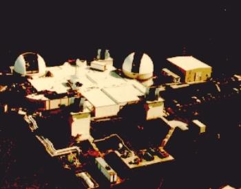
To perform its mission, GEODSS brings together the telescope, low-light-level television and
computers -- three proven technologies. Each site has three telescopes, two main and one
auxiliary, with the exception of Diego Garcia, which has three main telescopes. The main
telescopes have a 40-inch aperture and a two-degree field of view. The system only operates at
night when the telescopes are able to detect objects 10,000 times dimmer than the human eye can
detect. Since it is an optical system, cloud cover and local weather conditions influence its
effectiveness.
The telescopes move across the sky at the same rate as the stars appear to move. This keeps the
distant stars in the same positions in the field of view. As the telescopes slowly move, the
GEODSS cameras take very rapid electronic snapshots of the field of view. Four computers then
take these snapshots and overlay them on each other. Star images, which remain fixed, are
electronically erased. Man-made space objects, however, do not remain fixed and their
movements show up as tiny streaks which can be viewed on a console screen. Computers
measure these streaks and use the data to figure the positions of objects such as satellites in orbits
from 3,000 to 22,000 miles. This information is used to update the list of orbiting objects and sent
nearly instantaneously from the sites to Cheyenne Mountain Air Force Base.
RESOURCES
http://www.fas.org/spp/military/program/track/geodss.htm
Maintained by Steven Aftergood
Originally created by John Pike
Updated Saturday, June 28, 1997 10:47:06 AM